By ANN GREEN
Terri Kirby Hathaway holds up a brown, heart-shaped sea bean as she relates its remarkable journey from a tropical rain forest to a far-away ocean shoreline.
The small sea bean or drift seed fell from a tropical vine into a stream or river and was carried downstream to the ocean, explains Hathaway, North Carolina Sea Grant’s marine education specialist.
“Sea beans can float up to 30 years in the ocean current,” she says. Every so often, small drift seeds wash up on North Carolina shores, after being transported by wind and currents such as the Gulf Stream.
The seed’s journey is just one lesson at the Centers for Ocean Sciences Education Excellence SouthEast (COSEE-SE) Ocean Sciences Education Leadership Institute, an annual residential professional development opportunity for classroom teachers and educators at museums, aquariums and education centers in North Carolina, South Carolina and Georgia.
To help the participants understand ocean density, Hathaway leads inquiry-based activities from the Maury Project, a comprehensive national teacher program, developed by the American Meteorological Society. The enrichment program is based on studies of the physical foundations of oceanography.
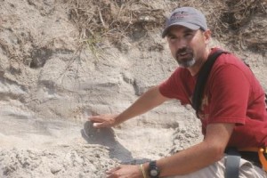
Antonio Rodriguez shows how geologists use sand to date storms. Photo by Elizabeth Vernon Bell.
For one activity, Hathaway, a Maury peer trainer, shows teachers how to plot temperature and salinity data from a simulated shipboard water sample.
“I will adapt this lesson for my 5th grade class,” says Ginny Pridgen, a teacher at Union Elementary School in Shallotte. ‘The 5th grade curriculum in North Carolina has a unit on weather. I also can use these lessons in the land formation unit.”
The 2010 COSEE summer institute, titled “Seas of Change: Exploring Southeastern Climate Change,” brings Pridgen, Hathaway and others to North Carolina State University in Raleigh and the Trinity Center in Salter Path.
Over nine days, regional marine and climate scientists join the educators to explore the connections between climate change and the ocean, with particular focus on the southeastern region. Climate-change topics include sea level rise, sea surface temperature and ocean chemistry.
“There are a lot of misconceptions about climate changes,” says Jessica Whitehead, Sea Grant climate extension specialist in North and South Carolina.
These changes may not have much of a visible effect on the teachers, but changes will be seen in their students’ lifetimes, adds Whitehead. “It is incredibly important to educate young people about what climate science can and can’t tell them about future conditions.”
Thus COSEE-SE continues a focus on climate change and adaptation for a second year. “We realized that climate change was at the top of everybody’s list,” says Lundie Spence, COSEE-SE director.
“We are building a community of scientists and teachers that can share information with each other.”
ADVANCING OCEAN EDUCATION
Funded by the National Science Foundation since 2003, COSEE-SE serves North Carolina, South Carolina and Georgia. The organization, part of a national network of COSEE thematic and regional centers, is headquartered in Charleston, S.C., at the South Carolina Sea Grant Consortium. Partners include North Carolina and Georgia Sea Grant programs and the University of Georgia Marine Extension Service.
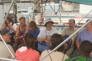
COSEES SE Institute participants take a ferry from Beaufort to Shackleford Banks. Photo by Ann Green.
Twenty elementary, middle and high school teachers, as well as an Ohio exchange teacher from COSEE Great Lakes and a Chinese fisheries professor attended the 2010 institute.
“I am interested in outreach strategies and want to set up a similar program like COSEE in China,” says Min Lu, associate professor of marine sciences at Xiamen University in China.
In addition to the COSEE SE partners, the institute affiliates included NC State’s Science House and Department of Marine, Earth and Atmospheric Sciences; N.C. Aquarium at Pine Knoll Shores; U.S. Fish & Wildlife Service; and the State Climate Office of North Carolina. Other affiliates included the National Oceanic and Atmospheric Administration’s National Centers for Coastal Ocean Science and Center for Coastal Fisheries & Habitat Research; NC State’s Center for Marine Science and Technology; the University of North Carolina at Chapel Hill Institute for Marine Sciences (IMS); the College of Charleston; Geodynamics LLC; National Institute of Environmental Health Sciences; and East Carolina University.
Participating educators are selected based upon professional development needs, as well as the percentage of students in their classrooms who represent groups that are traditionally underrepresented in marine sciences. The COSEE-SE staff also considers the teacher’s experience and the desire to integrate marine science inquiry into the classroom.
New and experienced teachers attended the institute.
“The institute has helped me connect with teachers who have a lot of experience,” says Channing Bennett, a 2010 UNC-CH graduate and science teacher at Smith Middle School in Chapel Hill. “It is nice to have the COSEE family as a resource and have those people to rely on.”
COSEE-SE programs are so popular that many teachers return to the program as team leaders.
Kyle Pierce of Lake Norman Charter High School in Huntersville participated in the 2008 workshop. Pierce has returned to help facilitate the institute, along with COSEE-SE coordinators Elizabeth Vernon Bell from South Carolina and Carrie Thomas, an NC State faculty member.
“COSEE is an amazing program,” Pierce says. “I always get new ideas for my classroom and updated statistics and develop new relationships with teachers.”
CLIMATE CHANGE
Over the past half-century, the ocean has absorbed about four-fifths of the warmth added to the Earth’s climate, according to the Intergovernmental Panel on Climate Change (IPCC) website. Arctic sea ice is melting at a rapid pace. Ice sheets are retreating, and the meltwater is flowing into the ocean at a fast rate, the IPCC reports.
During the 1990s, measurements for global mean sea level rise and sea levels along the Atlantic coast indicated a higher rate than at any other time during the 20th century, contributing to erosion along vulnerable shorelines.
Changes in the climate — including those associated with human-induced climate change — show large cycles of thousands of years, with smaller fluctuations in 100-year periods or even within decades.
Current predictions of the rate of climate change threaten coastal communities and agriculture. Even if carbon dioxide concentrations — a contributor to warming climates — are stabilized, assessments by the IPCC show that warming will continue for decades, and sea level will keep on rising for centuries.
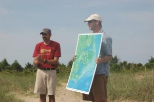
The field trip gives teachers new perspective when reviewing the map that Greg Rudolph displays. Photo by Ann Green.
Scientists derive long-term estimates of global average temperature from other indicators or proxies such as Ice cores, sediment cores and tree rings. Estimates from ice cores provide good ranges for temperature and carbon dioxide concentrations in the atmosphere 600,000 or more years ago, according to the State Climate Office of North Carolina website.
Because ice core samples aren’t available in North Carolina, researchers use tree rings from a few selected sites that go back nearly 2,000 years to track climate changes. Data from the state’s trees have been combined with tree ring estimates across the eastern United States to provide meteorologists with drought estimates back 2,000 years.
Recorded statewide observations of temperature and precipitation patterns only date back to the late 1800s. “The observations in North Carolina are limited and generally don’t show any meaningful increasing temperatures associated with global warming,” notes North Carolina’s state climatologist Ryan Boyles. In addition, “the best current climate models have been shown to inadequately simulate past weather conditions in North Carolina.”
North Carolina temperatures are more variable from year to year than global averages, Boyles adds.
“From 1895 to 2009, the southeastern United States has overall trended cooler,” he says. “But that doesn’t mean climate change is not affecting us. Changes in local vegetation and urbanization have influenced local conditions, as much as the broader climate pattern.”
However, North Carolina’s coastal environment is closely linked to global changes because of rising sea level. Observations show that the sea level on the state’s coast has risen about one foot since scientists began tracking it during the 1930s.
“Sea level in North Carolina will continue to rise,” Boyles says. This will particularly affect shorelines of low-lying counties in northeastern North Carolina, he adds.
Coastal climate changes affect water resources and the environment not just along the coastline, but into the coastal plain region that includes vast estuaries.
Whitehead works with municipal and county managers to explore how they can adapt to climate change risks, including sea level rise.
“I tell managers ‘not to panic,'” she says. “You don’t have to have a perfect solution finished tomorrow for the next 20 years, but you can decide what path you are going to investigate to come up with flexible solutions.”
Whitehead says that government officials need to be able to manage a variety of hazards, including floods. Many of the actions they take to manage today’s hazards also will help them cope with climate change, she says.
“Managers need to develop projects that have these multiple benefits,” Whitehead adds.
BEACH ACTIVITIES
During the COSEE-SE institute, scientists present results from research projects, introduce teachers to classroom activities and lead field trips.
On Shackleford Banks, part of the Cape Lookout National Seashore, North Carolina Sea Grant researcher Antonio Rodriguez leads a trek across the island from Bogue Sound to the Atlantic Ocean.
While standing at the ferry dock, Rodriguez uses maps to illustrate sea level changes. ‘The North Carolina coast is unique,” he says. “It has right angles or geologic ridges that formed capes during advancing sea level.”
As he holds up a satellite map, Rodriquez points to sand ridges that run north to south and that are remnants of barrier islands that existed up to 125,000 years ago.
The Suffolk Scarp, a long ridge of prehistoric beach that once marked the edge of the sea, crosses Plymouth and winds to the Neuse River. “A beautiful scarp parallels the modern coast of North Carolina and cuts across at right angles across the Neuse River and at Morehead City,” Rodriguez explains.
Shackleford Banks and some other barrier Islands were formed because of sea level rise from glacial meltwaters, he adds.
“Sea level has been rising at an average rate of about 3 millimeters per year along North Carolina’s coast,” says Rodriguez, a UNC-CH IMS researcher. “This is based on tide-gauge data.”
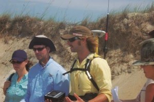
Chris Freeman (middle) and Ben Sumners (right) explain how GPS is used to map a beach’s morphological features. Photo by Ann Green.
Scientists differ on the causes of sea level rise, he notes.
As teachers walk along a sandy path crossing the island, coastal geologist Chris Freeman points to brown horses In a low grassy area. These horses are not indigenous to the island and congregate at several of these water tables found across this island, he explains.
“If you come in here and dig 1.5 feet, you get almost-fresh water,” says Freeman, president of Geodynamics LLC in Morehead City.
“The horses have been a big management issue because large populations can overgraze the island vegetation,” Freeman adds.
As the group reaches the ocean, Freeman explains how a Global Positioning System (GPS) is used to profile the beach from the water’s edge to the dunes and beyond.
Geologist Ben Sumners of Geodynamics straps the equipment to his back to illustrate how this terrestrial surveying technology is used to map the beach’s morphological features. Sumners walks across the sand to map erosional hot spots.
‘This GPS is hooked to the Internet to get accurate horizontal and vertical measurements,” Freeman says. To get a true beach profile, the geologists use special sonar combined with high accuracy GPS techniques to create a profile that extends over one mile offshore.
“All these instruments help us calculate the elevation of the sea floor and measure change overtime,” he adds.
As waves crash on the shore, Greg Rudolph of the Carteret County Shore Protection Office gives a lesson in sand composition. “Sand can be made of anything, including granite, shell and limestone,” he says.
Teachers use a lens to magnify the sand grains and see the sparkly crystals of quartz and feldspar.
“This field trip increased my content knowledge,” Pridgen says. “I grew up on Ocean Isle, but I never knew about sand composition.” As part of the Institute, she will be developing a unit on marine science careers.
“I want my students to know that there are many opportunities in marine science,” she says. “If a student Is fascinated by digging in the sand, he can become a geologist.”
Marsha Anderson of Gary High School will be incorporating new data on sea level rise and climate change into her marine ecology class. “I will give students a problem and let them solve it,” says Anderson, who teaches earth and marine sciences.
As part of the institute requirements, each teacher will help coordinate an Ocean Awareness Day (OAD) for his or her peer teachers. The workshops will be held at a museum, aquarium or education center that is part of the South East Portal to Ocean Research for Teachers network, known as SEPORT.
Anderson and several other teachers will be presenting an OAD at the N.C. Museum of Natural Sciences. They will focus on how climate change is affecting the ocean, including rising ocean temperatures, sea level rise and ocean acidification. Other North Carolina participants will be conducting workshops at the N.C. Aquariums and other educational centers.
“At COSEE-SE, we are giving teachers the opportunity to become leaders in their local school districts,” Bell says. “After completing the institute, we want them to feel confident enough to pass on the information to other teachers in their school districts.” — A.G.
**Access resources from the institute, view more upcoming COSEE SE programs or join the Climate Change Community of Practice: www.cosee-se.org.
**Watch the North Carolina Sea Grant online calendar for Ocean Awareness Days: www.ncseagrant.org.
**Find out more about the State Climate Office of North Carolina: www.nc-climate.ncsu.edu.
This article was published in the Autumn 2010 issue of Coastwatch.
For contact information and reprint requests, visit ncseagrant.ncsu.edu/coastwatch/contact/.