By ART LATHAM
Several months after Hurricane Irene washed out roads and left homes, cars and other property — as well as livelihoods and dreams — moldering in the sand, North Carolina’s coastal communities are mending.
“Hurricane Irene,” Irene Nolan, Island Free Press editor, notes online, “will be remembered for the two distinct inlets, multiple dune breaches, unprecedented soundside flooding, tenuous electricity and evacuees who couldn’t return home.”
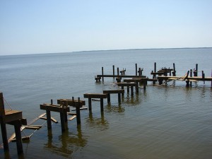
Hurricane Irene severely damaged a pier. Photo by Chris Layton.
The storm also might be remembered for how isolated coastal residents interacted in its immediate wake, with neighbor helping neighbor for days before outside assistance arrived, and long after.
Yet even in an often storm-ravaged, near sea-level coastal landscape, hope glimmers like fluorescence on midnight swells.
Case in point: The Hatteras Island Day at the Docks celebration. Since 2005, it has marked the island’s comeback from Hurricane Isabel, when N.C. 12 also was breached. DATD festivities now include the Blessing of the Fleet, which originated in 2004. Irene forcefully cancelled this year’s Sept. 17 DATD, but islanders rallied, holding the Blessing of the Fleet on Sept. 30. The weather was fine.
“The Blessing always exudes the timeless resilience and strength of the villages on the island,” says Susan West, longtime island resident and journalist, “but this year the symbolism was heightened, as residents of the island continued to deal with the aftermath of Hurricane Irene.”
Several Dare County residents, including West, reacted to the storm in another, uniquely contemporary way: through social media.
Irene, several hundred miles wide when it hit Dare, cut off phones and electricity with impunity. With intermittent cell phone reception and no landlines, islanders at first sent emergency messages by 800 MHz shortwave “ham” radio. Storm stay-behinds and later, returning islanders, used battery-operated computers and cell/smartphones to access Facebook and Twitter or blog their situations to each other, the mainland and the world.
To pass along critical information, county officials and others created storm-related Facebook pages with titles such as “Hatteras Island vs. Hurricane Irene,” with more than 5,000 “likes” by mid-October, and “Ocracoke Island meets Irene,” with more than 1,500 “likes.”
Stricken counties and the state passed along critical information on official websites and communities developed ad hoc pages linking to official pages and other information, and sharing personal perspectives.
The vivid scenes they posted from up and down the fragile Outer Banks and from sound and river banks varied as Irene approached, but shared a common thread: “This is bigger than we thought it would be.”
REALITY SET IN
Michael Halminski, a nationally known photographer and Hatteras Island resident since 1973, warily watched Irene’s water rise at the sound-side home he built. And for good reason.
“It came up over my porch by 11 that night, then rose two more feet to wet the underside of the floor system at about midnight. The sound had risen 8 feet, then an additional 2 feet, making the storm surge here 10 feet,” he says.
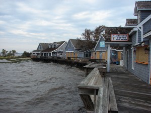
Raised sound levels caused flood damage to Duck’s Waterfront Shops. Photo by Chris Layton.
The surge soaked his under-house insulation, but didn’t invade his house. He lost his uninsured beach buggy and his truck.
He wasn’t alone. Many islanders parked their vehicles around the Waves post office, which hadn’t flooded in generations. But this time, it flooded, as did areas all over Rodanthe, Waves and Salvo, the “tri-villages.”
In the aftermath, on Sept. 7, Halminski reported online via a slide show at photoblog.michaelhalminski.com. His comments include:
“Despite our well-intentioned preparations, Hurricane Irene took everyone in our villages by surprise. I knew we were going to have a significant storm surge from the Pamlico Sound, as in storms of the past, but not to the extent that we got.”
Halminski says Irene generated a surge across his property almost three times deeper than Floyd’s and Bonnie’s, and at least a foot higher than the infamous March 1993 storm.
“Old-timers who had used ‘the storm of 1944’ as a comparative benchmark now must use Irene’s flooding,” he says.
“Flooding back then was apparently somewhere between the March storm and Irene,” he notes in his blog.
But, “Irene brought in more storm surge from the sound than any storm for the last 75 years. It is now the new benchmark for sound-side flooding in our villages on this part of Hatteras Island.”
HITTING THE WORKERS
Sara Mirabilio, North Carolina Sea Grant fisheries specialist, weathered out Irene’s winds and rains on the Outer Banks.
“Storms don’t affect Dare County equally in all areas,” she says. “Countywide, some areas are more prone to ocean overwash and others to sound flooding; some areas more exposed to the winds, some to the water.”
Irene concentrated not on luxury beach homes, but headed straight for the barrier islands’ “back” sides, where many year-round residents live along the sounds or inlets and rivers that feed them. The storm destroyed sound-side docks and modular homes, and flooded older homes built on the ground with marginal crawl spaces.
Severely damaged areas included sound-side Colington in northern Dare, and Stumpy Point, Mann’s Harbor and other small waterside fishing communities on the mainland west of Roanoke Island, as well as Manteo. In the tri-villages, damages were so severe that officials kept the area closed into October.
Some marine-oriented businesses in northern Dare and on Hatteras survived.
“Commercial fishing was the first industry to come back online,” Mirabilio says. “Area fish dealers got reefer trucks approved for crossing on the Rodanthe-to-Stumpy Point emergency ferry almost immediately to allow shipping of seafood products to market.”
But recreational charter boats, she says, “sustained a huge blow.” Oregon Inlet Fishing Center was closed for nearly a month and the entire fleet relocated, most to Pirate’s Cove in Manteo.
“Tourism businesses have had to lay off people: winter layoffs came early this year,” Mirabilio notes. “And since few are working, there’s no cash flow.”
THE KINDNESS OF STRANGERS (AND NEIGHBORS)
Several groups and many individuals worked and continue to work to ease the load for islanders.
Salvation Army volunteers arrived first. For three weeks after the storm, they prepared hot meals in a mobile kitchen at the Rodanthe community building, Halminski says. When they left, the N.C. Baptist Men (and women) ran the kitchen until mid-October. Also, the Red Cross, the Illinois-based Operation Blessing International and others were on-site and on the job.
“The NCBM also volunteered their labor, doing tasks for neighbors like debris removal,” he adds. “They even had a mobile unit for doing our laundry and providing hot showers.”
Also, the Really, Really Free Market, a take-what-you-need service, temporarily relocated from Avon to Rodanthe-Salvo-Waves to handle the emergency situation.
And local volunteer fire departments moved supplies onto Hatteras Island, distributed materials, served as feeding stations and got “down and dirty and doing things like ripping insulation out of people’s homes,” Mirabilio recalls.
Repeatedly, Dare County Web posters offered testimonials to neighbors who pitched in to help.
Still, even the best of intentions couldn’t improve economic situations until N.C. 12 reopened Oct. 10. The sole paved lifeline across Pea and Hatteras islands, the thin asphalt strip continues on Ocracoke Island in Hyde County, accessible only by ferry.
Longtime Ocracoke Village resident Ann Ehringhaus was off-island when Irene hit.
She returned to find the worst damage — other than wind-toppled trees and debris — seemed to be deep sand over N.C. 12 near the Ocracoke-Hatteras ferry terminal, possibly due to an overwash.
“All our infrastructures were very taxed,” she explains. “What’s the hardest for us now is the recovery to our economy. We have a lot of restaurants here and there aren’t enough people.” Nor were supplies easy to come by.
Several restaurants, usually open until the end of October, closed in September or early October. Despite a steady traffic stream to and from the island’s two ferry docks — north to Hatteras or south to mainland Cedar Island or Swan Quarter — not many people stopped in Ocracoke, Ehringhaus says.
The problem, she says, as it was on Hatteras, was that major vendors — food suppliers, UPS, the U.S. Postal Service — normally roll in from the north. They had to wait to board the crowded emergency ferry from Stumpy Point to Rodanthe, then had to ride the usual ferry from Hatteras to Ocracoke.
The same logistics in reverse applied to fish catches from Hatteras and Ocracoke.
On Hatteras, islanders had neither electricity nor refrigeration, and many homes were condemned. Ocracokers endured rolling blackouts. Into October, Hatteras Islanders lacked even basic necessities, such as “school supplies, plastic totes, cleaning supplies (bleach), linens, blankets, white rubber boots, clothing, socks, shoes, shampoo, soap” and more, as posted on Jennette’s Pier’s website.
As of mid-October, Hatteras residents, especially in the tri-villages and Avon’s Kinnakeet section, appreciated relief items, according to The Outer Banks Voice.
“Of course, there’s still the problem of how to get groceries when your car is full of marsh grass and the electronics are shot,” islander West notes.
Yet even in one of the worst-hit areas on Hatteras Island, work continues to build a framework for a brighter tomorrow.
Both West and Mirabilio are with Saltwater Connections, which continues its pre-Irene work of asset mapping and other community development projects. Team members meet residents, business owners and other leaders, and view each village’s important cultural and natural assets, with an eye towards consensual and sustainable community building.
Mirabilio and Karen Amspacher, the Core Sound Waterfowl Museum and Heritage Center director who landed the N.C. Rural Center grant that jump-started Saltwater Connections, met with key islanders “to see if our priorities should be shifted in the aftermath of Irene,” Mirabilio says. “So far, things that were a problem before the storm, like affordable housing, are still a problem after the storm, but just tenfold.”
A Saltwater Connections Resource Team visited the tri-villages and Avon in May and was to return to present findings and recommendations in late August. The scheduled date turned out to be the same day officials issued an evacuation order for Ocracoke and it was clear that an order for Hatteras Island was pending, she says.
The team revisited Hatteras Island in late October, meeting Buxton, Frisco and Hatteras Village residents, and to present the storm-delayed recommendations.
“As you can imagine,” West says, “the mood on the island today is much different than in May when business owners were looking forward to what they hoped would be a good season. I don’t believe that many people talked to the team in May about hurricanes, but Sara has done some great work organizing and conducting interviews about post-storm recovery efforts on the island.”
Saltwater Connections members appreciate and try to nurture cultural traditions that hold islanders together through fair weather and foul. The resilience Hatteras Islanders showed in insisting on this year’s Hatteras Island Blessing of the Fleet ceremony boosts their optimism.
“The Blessing served as affirmation of what has been happening here every day since the storm,” West says, “with folks from all over the island and the county working together to help friends and neighbors and even strangers in both big and small ways.”
Need more information? Try these websites:
• Blessing of the Fleet, Hatteras: www.youtube.com/watch?v=FhmAOFaQJz0
• Dare County: www.darenc.com
• Irene by the numbers: http://www.ncdps.gov/Emergency-Management/Recent-Disasters/Hurricane-Irene-2011
• Saltwater Connections: saltwaterconnections.org
This article was published in the Holiday 2011 issue of Coastwatch.
For contact information and reprint requests, visit ncseagrant.ncsu.edu/coastwatch/contact/.