By SHARON SETTLAGE
Habitat — it’s a word you’ll see often in the North Carolina Coastal Habitat Protection Plan.
What does the blue crab have to do with the six major habitats defined by the plan? All are needed during its complex life cycle. Take away a habitat and the state’s number one fishery might be jeopardized.
In fact, many fish use multiple habitats over the course of a lifetime. Different habitats provide refuge, spawning, foraging and nursery areas for many sea animals during their life cycles.
That’s why the North Carolina Coastal Habitat Protection Plan, or CHPP, defined the characteristics of these six habitats:
- The water column is low in sediment and pollutants, and flows unobstructed, connecting the other aquatic habitats.
- Shell bottom is made up of concentrations of living and dead oysters, clams and other shellfish.
- Submerged aquatic vegetation, or SAV, consists of grasses and other plants that are always underwater.
- Wetlands are commonly referred to as swamps or marshes.
- Soft bottom is an unconsolidated, unvegetated, sandy or muddy base.
- Hard bottom is a rocky outcrop found in oceans or rivers, often attracting a rich abundance of adult and spawning fish.
Each was considered when the Strategic Habitat Area Advisory Committee recommended areas of excellence in North Carolina’s coastal plain for nomination as Strategic Habitat Areas or SHAs.
The CHPP document, first published in 2005 and updated in 2010, calls for the nomination of SHAs. The Fisheries Reform Act legislated the creation of CHPP. Protecting and enhancing fisheries is the goal in identifying and caring for areas essential for fish reproduction and growth.
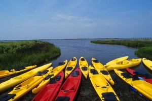
Kayaks back from a trip on the Pamlico Sound. Photo courtesy VisitNC.com
The CHPP steering committee is made of representatives from Marine Fisheries, Coastal Resources, Environmental Management and Wildlife Resources commissions. The committee holds quarterly public meetings to evaluate strategies and hear research reports.
In addition to division directors and N.C. Department of Environment and Natural Resources senior staff, a variety of state environmental officials frequently attend the meetings.
“One of the driving goals of CHPP was to unite agencies and to unite divisions and departments within agencies that all have some responsibility for environmental quality that affects fish,” notes Pete Peterson, chair of the CHPP steering committee and vice-chair of the Environmental Management Commission.
The committee established a systematic approach for the identification of the SHAs and divided the North Carolina coastal plain into four management regions.
Region 1 assessment was completed in 2009. Region 1 includes the Albemarle and Currituck sounds and the Chowan River.
The Pamlico Sound area, which includes its tributaries up to the fall-line near Rocky Mount, Roanoke Rapids and Smithfield and 3 miles of ocean waters from the shoreline, was chosen as the second region to examine due to its importance to North Carolina’s fisheries.
Region 3 includes Core and Bogue sounds, and New and White Oak rivers. Region 4 includes the Cape Fear River and southern estuaries.
Jen Weaver, a graduate fellow funded by both the N.C. Division of Marine Fisheries, or DMF, and North Carolina Sea Grant, was a key player in marking the SHAs for Region 2. Fellow Tim Ellis helped DMF with Region 1.
FISHING THE PAMLICO
The Pamlico Sound, which is the largest body of water in the four regions, is known as the fishing gem of North Carolina.
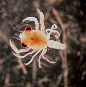
The megalopa, or blue crab in the second larval stage, migrates into the estuary and is attracted to eelgrass. Photo by David Eggleston.
A multiplicity of habitat features contributes to the high diversity of the Pamlico system. This includes SAV, oyster-rich rocks and primary nursery areas for juvenile species. All six habitat types occur in the region and make it a prime spot for fishing.
Just ask Capt. Adam Jones, owner of AJ’s Sea Duck and Trophy Swan Hunts. “Sometimes we catch and release 25 red drum in a trip,” Jones explains. He says that the fishing is best in late July to September when the red drum migrate with mullet into the sound. “Everything they need to support them is here,” he adds.
It’s the same for the blue crab. “Blue crabs are unique in that they use all the habitats in the Pamlico Sound estuary,” comments David Eggleston, a North Carolina State University marine biologist who has tracked blue crab movement with funding from state and federal research programs administered by Sea Grant.
Blue crabs use soft bottom for overwintering and protection from predators. The young megalopa and crabs in the softshelled stage live in the SAV. Adults forage in hard bottom, shell bottom and wetlands.
The water column is important as the crabs swim about. The females tend to stay in the more saline estuary, while the males may move up the less saline tidal creeks. They meet at the mouths of the creeks for mating.
Wetlands, shell bottom and SAV not only directly provide habitat to animals like blue crab, but also are particularly important for improving water quality. They reduce erosion, filter water and slow wave activity.
INTEGRATING INFORMATION
Over the course of years, DMF and other researchers have studied the North Carolina coast in an effort to map the many features important to state fisheries. Maps of the locations of important habitats helped identify the SHAs.
Sea Grant and DMF jointly award a fellowship each year to an exceptional student to work on fisheries issues under the direction of aquatic biologist Jeff Buckel at NC State’s Center for Marine Sciences and Technology in Morehead City.
Weaver, who has a Master of Environmental Management degree from Duke University, came on board as the DMF fellow to analyze fisheries monitoring numbers collected from the Pamlico Sound. These statistics would be part of a massive data collection used by the DMF with sophisticated computer software to nominate SHA locations.
When her mentor at DMF found a position elsewhere, Weaver was able to step up to the plate. Her work experience primed her for tackling extensive data sets and also interacting with the various stakeholders in the SHA nomination process. She had held previous positions performing geospatial analysis in coastal wetlands during an internship with the Environmental Defense Fund and in her master’s research.
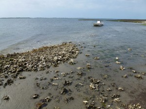
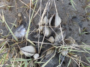
Shell bottom filters pollutants, slows erosion and is a prime fishing spot. Photo by Sharon Settlage.
Buckel has high praise for Weaver’s work. “The fellowship is designed such that a recent graduate from a master’s or Ph.D. program can see what it’s like at the front lines, but that’s usually at a distance. She was actually there.
“Jen really went above and beyond her job description in this process. She came in and helped DMF out quite a bit more than they had planned. I was impressed with Jen’s knowledge and her ability to run the software and manage the large databases. She did a great job in the fellowship,” he adds.
Most would be overwhelmed by the amount of data accrued by the DMF in order to analyze the coastal plain.
In fact, the DMF maps designate the six major habitat features of the Pamlico Sound — and more. In order to determine which areas contribute to good fisheries, and which areas do not, one needs maps on positive and negative impacts. The positive aspects already have been mentioned; they are the six habitat types. But within each of these are subsets, such as estuarine and marine soft bottom, high-salinity and low-salinity SAV, and so forth.
Other designations include primary nursery areas, fish abundance and the occurrence of rare species.
The negative impacts, also called alteration factors, are human activities that may affect habitat quality or are indicative of reduced habitat quality, including areas of prohibited shellfish harvest, dredged channels, industrial waste, military targets, animal operations and more.
“It’s one of the few examples where I’ve seen anything like it at the state level — where there’s been an effort to characterize habitats based on the anthropogenic alterations to an area,” Weaver says.
CRUNCHING NUMBERS
Weaver input data on 24 alteration factors and 35 distinct habitat types into the site-selection program called MARXAN.
MARXAN, officially known as MARine eXplicit ANnealing, is used worldwide to determine pristine natural areas. A doctoral student in Australia designed MARXAN and first applied it to the Great Barrier Reef of Australia.
In order to input the data into MARXAN, Weaver divided the study area into hexagon areas of 124 acres each. She then calculated a score based on the amount of habitat and human alteration for each of the more than 19,000 hexagons that make up Region 2.
A committee of fisheries specialists met to corroborate the MARXAN output based on expert knowledge of the region. In the end, 67 discrete areas were nominated as SHAs, representing 10 percent of the area of Region 2.
Of the nominated SHAs, 11 percent are contained in federally or state-owned lands, areas already managed for conservation, or protected as primary nursery areas for fish. These include parts of Alligator River National Wildlife Refuge (NWR), Mattamuskeet NWR, Swan Quarter NWR, Cedar Island NWR and Cape Hatteras National Seashore.
“It’s really great that North Carolina is incorporating the link between habitats and fisheries production in its management plans,” Weaver says.
THE CHESAPEAKE BAY: A CAUTION
The Pamlico Sound is one of the largest estuaries in the United States, with a higher species diversity than the largest estuary, the Chesapeake Bay, according to a study published in 2006 in the journal, Science.
SAV is a factor contributing to the productivity of the Pamlico Sound and other estuaries, such as the Chesapeake Bay. But, SAV is like the proverbial canary in a coal mine — it dies off when water becomes overloaded with nitrogen, phosphorous, pollution or sediment.
Beginning in the 1960s, SAV declined precipitously in the Chesapeake Bay. As the SAV disappeared, so did the waterfowl that are dependent upon the plants for food. The year 2007 was the poorest blue crab harvest on record for the Chesapeake, and the U.S. Secretary of Commerce declared an economic disaster for bay-area watermen.
Recognizing the importance of SAV, the U.S. Environmental Protection Agency funded biologists to conduct yearly aerial monitoring of Chesapeake Bay SAV. Because SAV is an indicator of good water quality, mapping provides a means to evaluate water health. This effort shows a slight increase in SAV since 1985, but it has not rebounded to pre-1970s levels.
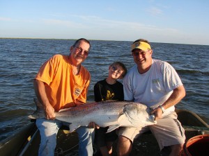
AJ’s Sea Duck and Trophy Swan Hunts takes fishermen into the Pamlico Sound for red drum.
Guidelines to protect SAV in the Chesapeake include restrictions on dredging near SAV beds. Water quality has improved in the bay, due to a 1983 agreement that reduced allowable phosphorous and nitrogen input into the bay’s tributaries. These changes should improve water clarity for the SAV. Efforts also are being made to plant SAV in areas that once supported large beds but now are completely bare.
North Carolina’s waters have lost SAV since pre-Colonial times, but the state has not seen die-offs like those in the Chesapeake.
Beginning in 1981, various SAV mapping efforts have been done in North Carolina. The Albemarle-Pamlico National Estuary Program led an interagency effort to map SAV along the entire coast using aerial photography. The survey of the coast was published in 2011 and showed extensive areas of SAV along the sound side of the Outer Banks. In all, North Carolina supports more than 138,000 acres of SAV.
In regards to the SHAs, the occurrence of SAV was considered highly important and as a result, almost all of the areas with significant SAV also are contained within a SHA. Although designation as a SHA itself now does not carry with it any regulation, there already are some regulations in place to protect SAV in North Carolina.
WHAT TO DO NOW?
The nomination of the SHAs in the Pamlico Sound area leaves many people in the region wondering what happens next. The N.C. Marine Fisheries Commission has approved the SHAs, but they do not become officially designated as a SHA until a regulation is needed. The commission who oversees the habitat is responsible for the management. For example, if a regulation is needed for water quality, then the Environmental Management Commission would be involved.
Anne Deaton, habitiat specialist with DMF, emphasizes that management measures only will be considered when the entire coastal plain has been evaluated and “the state will welcome extensive public stakeholder involvement.
“The intent is habitat protection and enhancement to promote sustainable fishing activity, not restrict it,” Deaton continues. Additionally, the approved SHAs will be “useful for local government to encourage land conservation and best management practices adjacent to sensitive SHAs,” she says.
Deaton summarized that the comments were largely positive at a public meeting for input on Region 2 SHA nominations held in the N.C. Department of Environment and Natural Resources Washington Regional Office in October 2011. At the meeting, she reported that “the driving reason for conducting SHA analysis is because scientific literature indicates that protecting a network of priority habitat areas is an effective means of enhancing sustainable fisheries.”
Wetlands support wildlife and also filter pollutants. Photo by Sharon Settlage.
The meeting summary notes concern about potential fishing restrictions, particularly in Hyde County, where a large proportion of SHAs are sited.
Others stated that “the selection of a large amount of area in Hyde County was a recognition of the significance and the uniqueness of the area.” One participant noted that the wetlands are “important for so many resources,” and that the “SHAs represent aquatic assets that the area needs to support the fishing and tourism industry.”
A week after the meeting, the Hyde County Board of Commissioners passed a resolution contesting any regulation that comes about due to the SHA nominations.
However, the designations of the SHAs are simply a recognition of valuable fish habitats, such as SAV and the other five habitats types that work together to support the state’s fisheries, Deaton explains.
Peterson, CHPP committee chair, agrees. “The SHAs are a great example of where we need to think about working together, so our strategy is a holistic management effort,” he acknowledges.
Resources
To find out more about the Coastal Habitat Protection Plan, visit the NCDMF homepage at: http://portal.ncdenr.org/web/mf/ and scroll to the link on N.C. Coastal Habitat Protection Plan.
To see the North Carolina SAV map, go to the homepage for the Albemarle-Pamlico National Estuary Program at www.apnep.org/ and follow the Resources link to maps.
This article was published in the Summer 2012 issue of Coastwatch.
For contact information and reprint requests, visit ncseagrant.ncsu.edu/coastwatch/contact/.