.

Two Outer Banks villages underline the risks facing 700 more coastal NC homes and offer a look at options for moving ahead.
It’s happened 32 times at Buxton and Rodanthe since 2020. Timber pilings begin crackling even before they buckle, wood framing moans, the surf roars then and covers the sound of the collapse. In an illusion of gracefulness, water meets wood and the tide takes the house, sweeping it wholly as the framing twists and surrenders and the roof flattens.
What once was a home spreads across the surface. Insulation and carpet and blinds and roofing and paneling and porch rails and stairs come apart in the waves, some of it too dense for the ocean to carry, but much of it light enough for a debris field that will sprawl into the Atlantic.
Left behind: the microwave and refrigerator and the water heater and the toilets, later resting cracked or crumpled, half-buried in sand. Scattered across open beach: 2x4s and joists, wood siding and flooring and doors and shutters, even the oval sign that once hung over the carport with a snappy name for the family getaway — all of it with exposed nails and screws and shorn, jagged edges.
Down-shore wave action can drag wreckage from a single lost home and cause beach closures for 15 miles. Near and far: shards of glass, asphalt shingles, exposed wiring, tens of thousands of pieces of drywall and retaining walls and fences and sheds, chips of concrete from parking pads and pool decking.
Unleashed: household chemicals. Lead, cadmium, other heavy metals. Asbestos. Not to mention E. coli and other pathogens from a damaged septic system that bleeds into the ocean.
Some of the home’s ruins, waterlogged, will settle offshore, just under the surface, leaving a sparkling panorama to hide hazards below. And some of the house’s broken skeleton eventually will sink much farther out, settling in canyons, where it will take longer to decompose.
Among the costs of a single collapsed home: severed attachments with family property and history and a neighborhood, impaired water quality and stressors on sea life, the loss of recreational time on waters and beach for residents and tourists alike, and, of course, the jarring landscape of wreckage.

Cape Hatteras National Seashore, stewards of the sands around and between the Dare County villages of Buxton and Rodanthe, welcomes over 2.7 million visitors per year.
These beaches and waters are made for swimming and exploring, fishing and batting around beachballs. And although homeowners must contract with private companies to remove what’s left of their fallen homes, the National Park Service (NPS) and Dare County bear a lion’s share of the cleanup — more than 450 truckloads of it, in fact, in 2025 alone.
Over the last six years, NPS has brought together work crews to remove tons of home debris with front-end loaders and other heavy equipment. The Park Service also organizes several dozens of volunteers through repeated clean-up events. The North Carolina Beach Buggy Association rounds up dozens more, and yet more residents and visitors contribute to cleanup efforts on their own time and in their own ways.
For the Park Service, the cleanup of fallen homes never ends.
On September 18 last year, two days after a house collapsed in Buxton, Dare County held a public meeting about the issue. Dave Hallac, superintendent for Cape Hatteras National Seashore, reported that before the home fell, park staff — typically on wildlife management patrol — already had been spending their time “picking up pieces and parts of homes every single day now, throughout the year.”
Hallac said patches of bad weather loosen more fallen debris from the Atlantic. Once, after a low-pressure system moved through the area, several fiberglass pools had become stranded on the beach.
Park staff were collecting parts of septic systems on a daily basis, he added, noting that during a six-week stretch in 2024, “more than 20 wastewater systems were damaged and broke apart, in many cases requiring that we work with the state to post swimming advisories until the water could be tested to show that it was clean.” Swells from Hurricane Erin in 2025, he said, also deposited enough house debris and septic parts on Seashore beaches to fill nine full-size dumpsters — even though the storm, at its closest, was a couple hundred miles southeast of Hatteras.
Of the 32 collapsed homes in Buxton and Rodanthe over the last six years, 21 have fallen since September 2025.
So, how did we get here?

Sandcastles, Erosion, and Sea Level Rise
Why are so many homes in Buxton and Rodanthe falling from such precarious plots in the intertidal zone?
To start with, North Carolina’s barrier islands are dynamic piles of sand, always shifting and moving, says Stan Riggs, a coastal geologist whose research North Carolina Sea Grant has supported since the 1970s.
“Three thousand years ago,” he writes in Cape Lookout National Seashore: Paradigm for a Coastal System Ethic, “the oldest components of North Carolina’s modern barrier islands had begun to form.”
This coincided with the end of the last Ice Age, when sea level rise began to slow and the Outer Banks began to take shape, roughly in their current location. But at the peak of the Ice Age — 15,000 years ago — the barrier islands were 25 miles farther out to sea.
“The configuration of the Outer Banks today is like one frame of a movie of the coastline,” says Rob Young, director of the Program for the Study of Developed Shorelines, a joint Duke University and Western Carolina University venture. “And with sea level rise on the uptick, what we’re seeing now is the continuation of the movie.”
As the barrier islands have migrated, natural processes preserved beaches, estuaries, and ecosystems, says Young.
The islands’ movement and the changes that come with it “aren’t a threat to the Outer Banks themselves,” he explains, but “they’re a threat to infrastructure.”

The Outer Banks also face exposure on the Atlantic side to forceful wave action and currents. According to the NC State Climate Office, these waves and currents, moving to the south, shear away sand from much of the northern and central Outer Banks, including most of Hatteras Island, to redeposit it on the southern end of the island. Similarly, but to a smaller degree, this process occurs along Ocracoke Island, Cape Lookout, and Topsail Island.
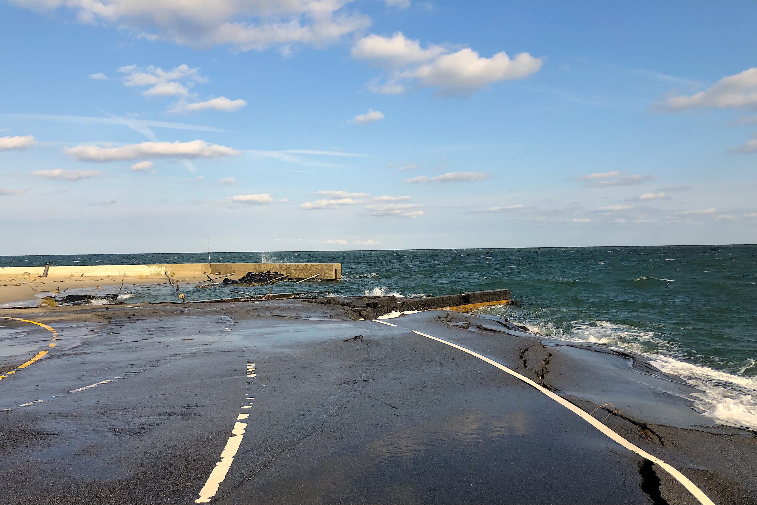
In addition to long-term coastal forces at play, change on the barrier islands can be severe and immediate. Storms scrape the shorelines of sand and cut new inlets, 54 of them alone from Hurricane Dorian on Hatteras’s neighboring islands to the southwest. Flooding tears up property, not to mention wreaking infrastructural mayhem — including ripping apart asphalt chunks and whole sections of Highway 12, the artery connecting many of the small towns and parks within the Outer Banks.
Accelerated sea level rise adds more water to the equation — and with it more flooding and erosion. Warming oceanwaters also intensify tropical storms and hurricanes, while generating more of them and heightening the ongoing threat.
As a result, Buxton, Rodanthe, and surrounding ocean-facing beaches have suffered striking shoreline change.
“We have some very quick rates of erosion,” Hallac said, at the September 2025 Dare County public meeting. “They do approach more than 10 or even 15 feet per year.”
Hallac termed it “a major issue” for homes in Buxton and Rodanthe. “One of the reasons those homes are standing upright is because those pilings are deep in the sand.”
When erosion narrows a beach, it also causes the vertical loss of sand. “So when you lose 5 feet of sand supporting those pilings,” Hallac explained, “it can make them much more vulnerable to collapse.”
All of which has left homeowners and planners without a lot of wiggle room. These sands along Cape Hatteras National Seashore aren’t vast. At some points, the stretch between Rodanthe and Buxton is barely 150 yards wide east to west, ocean to sound.

According to the NPS, though, some of the most imperiled houses in Rodanthe — products of the 1970s, ’80s, and ’90s — once were perched on properties with “backyard land, dunes, and dry sand.” There they sat, ostensibly safe, often hundreds of feet from the rising Atlantic and threatening coastal currents. For many homeowners, Hatteras Island has continued to morph and to move literally out from under their feet.
“None of them built these houses in the water or next to the water,” Hallac said at the same Dare County meeting. “In most cases, it’s just the ocean catching up to the houses.”
The immediacy of the threat today can leave homeowners overwhelmed, baffled, saddened, and facing cold realities.
“This is more than a science issue,” said a Rodanthe resident at the meeting. “This is a personal issue, and I don’t know if you’ve ever had the unfortunate opportunity to listen to a house fall into the ocean. It sounds like ribs being cracked during CPR.”
After Dare County had announced it was moving up its latest effort to renourish Buxton’s beach by a year to 2026, another resident at the meeting predicted immediate and radical changes to Buxton’s oceanfront properties, particularly for one precarious stretch of houses.
“Unfortunately,” he said, “I think a lot of you guys on Tower Circle are going to have to come to the realization that your house probably won’t be there for beach nourishment. I know that’s a tough pill to swallow.”
To him, nature was operating on a different timeline.
“I think we need to be real about the condition of Buxton right now,” he added soberly, noting that more homes at that time already were standing in tidal waters. “I mean, all you homeowners on Tower Circle. . . I mean . . . I really don’t think your house will be there — any of them — this April.”

After the public meeting, Tower Circle Road would lose three more houses within two weeks and a total of 10 more before Buxton’s beach renourishment would begin. All told, Buxton lost 19 more homes after the September 2025 meeting, totaling 20 losses before the July 2026 start of the project.
Another Buxton resident at the meeting had just watched the Atlantic take her next-door neighbor’s house two days before. She pointedly asked county and state officials, “What can you do to help me make sure my house doesn’t fall in the ocean?”
And here’s where it gets complicated.
Strategically Waiting for Catastrophe
Julie Youngman, senior attorney for the Southern Environmental Law Center, says Buxton and Rodanthe present contexts with a wide set of challenges.
“When the writing is on the wall and a house is dangerously close to collapsing,” she says, “we want to encourage people to demolish or move their house before it’s too late. There have been houses, though, where once the owner realizes that it’s beyond salvaging — when they know that the beach has eroded too far and they’re not going to ever be able to live in that house again — it’s turned out to be too late, and they haven’t been able to find a contractor willing to risk their equipment to move or demolish the house.”
Although sometimes a blend of uncertainty and delayed decision-making contributes to the swirl of complexities in play, in many cases, there’s a simple reason that homeowners don’t opt to move their houses or to contract for controlled demolition.
Insurance doesn’t work that way.
In order to file a flood insurance claim, homeowners have to wait until their houses fall. Up until that point, homeowners bear the financial burden for relocating or demolishing homes that have suffered damage or that face imminent collapse.

To move a house, a homeowner must secure a suitable plot of land and navigate through a permitting process even if relocating on the same lot. News accounts have noted that the costs of moving a house — raising it off its pilings and transporting it intact — can top $200,000, depending on the size of the home and distance involved.
At present, though, the National Flood Insurance Program covers no expenses for relocating a damaged or endangered structure. In addition to the six-figure outlay for relocating a house, the homeowner has to cover permitting, new hook-ups, and, in some cases, a new lot.
But in this scenario, despite the expenses, a homeowner can hope to salvage something out of the situation, even if only buying a few years by moving on their own property farther from the ocean. In fact, one resident at Dare County’s September 2025 public meeting reported unsuccessfully trying to navigate the steps required in the process before her home collapsed.
It can be considerably quicker and cheaper to demolish a home. Controlled demolition keeps taxpayers from bearing the brunt of a collapsed home’s cleanup through National Park Service and Dare County efforts, as well as protecting the coastal landscape and seascape.
But demolition leaves no house at all for the money spent.
“We need to do whatever we can to encourage people to do the right thing, while there’s still time,” says Youngman. “But I can sympathize with the people faced with these decisions. I think it would be very hard to imagine taking a house that had a $300,000 mortgage left on it, for instance, and voluntarily tearing it down.”
Which is why, for homeowners, simply abandoning a house once it becomes unlivable often makes the most financial sense.
Before it comes to that, though, there’s often hope that beach renourishment will save the neighborhood.

Sand and More Sand vs. Surf
Coastal communities often turn to beach renourishment with hopes of keeping oceanfront properties out of danger and recreational areas open. A new $40-million effort in Buxton recently added 2 million cubic yards of sand to the beach over 95 days.
“Beach nourishment buys time, and that time has real value,” says East Carolina University’s Reide Corbett, who grew up on the coast and has served as director of ECU’s Coastal Studies Institute. “It helps protect infrastructure and reduces near-term risk. But it doesn’t change the underlying forces driving long-term shoreline erosion.”
Corbett says beach nourishment may remain a viable strategy for some communities.
“But high rates of erosion or costs may make it increasingly difficult for others,” he adds. “The question is how we use the time nourishment gives us to plan for a changing coastline.”
Often designed to preserve beaches for five-year stretches, Dare County’s beach renourishment projects must survive unpredictable hurricane seasons, as well as nor’easters and other storms, along with those relentless long-term coastal forces at play — all of which can shorten the actual timeframe of a project’s protective value.
“I think towns are typically surprised when they think a nourishment project will last for five years,” says Youngman. “And then after two or three years, the sand’s all gone.”
The latest project to fortify Buxton’s oceanfront is its third beach renourishment in nine years.
At the September 2025 Dare County public meeting, Hallac noted that within months of the County’s 2017 beach renourishment for Buxton, “after some storms, the ocean was still washing across the highway. They redid the beach nourishment project again in 2022,” he continued, “and within a year we had structures that no longer had dunes in front of them — and the same structures we’re talking about today.”
When renourishment can’t survive its planned timescale, surf eventually pounds at more house pilings, which led to the 20-home loss in Buxton from September 2025 to this past June.

Information from Dare County notes protections for Highway 12 — and for tourism more broadly — as added advantages of beach renourishment. The County has already completed projects in Avon and Nags Head in 2026, with more slated next year for Kitty Hawk, Kill Devil Hills, Duck, and Southern Shores. No renourishment is publicly scheduled now through 2027 for Rodanthe, yet the County reportedly has sought $40 million in external funding to add sand there, too.
Dorothy Hester, Dare County’s chief public information officer, says rising costs “could make even existing commitments more challenging over time.”
If we look strictly at beachfront costs and benefits, does renourishment make fiscal sense?
It may not for Rodanthe, according to a white paper from the Program for the Study of Developed Shorelines. Researchers analyzed the costs of buying 80 of Rodanthe’s most endangered houses at their assessed values, demolishing and safely removing them, and the lost tax revenue that would result. They then compared the costs with the price of beach nourishment.
“The numbers weren’t even close,” says Rob Young. “And I think that we overestimated what property owners would sell for.”
The cost to purchase and safely remove 80 houses now: $43 million. The price tag on three renourishments for Rodanthe over 15 years: $120 million.
“There is a misimpression,” Young says. “Everybody thinks ‘we can’t walk away from this. It’s a critical part of our tax base.’ But then, if you sit down and add up the numbers — what we pay to defend those properties — there are places where beach nourishment makes sense, and there are also places where it does not.”
In the case of Rodanthe, it would be tens of millions of dollars cheaper not to renourish the beach, give homeowners a way out, and avoid the wreckage of 80 more homes in the Atlantic.
“We tend to spend most of the resources fighting losing battles in places that we could take a baby step back from,” Young says. “But we could use all of that time and energy — all the planning resources and emergency management resources and the money — to support the sustainable parts of the community. In the long run, to me, this is how you preserve the coastal economy.”

Hunkering Down and Hardening Up?
Although coastal residents and municipalities often advocate for beach renourishment, the temporary nature of a couple million cubic yards of sand isn’t lost on many homeowners either, which is why some are calling for seemingly more permanent solutions — like seawalls, groins, and other hardened structures.
“There’s this perception that North Carolina is the only state that bans all hardened structures,” Julie Youngman says. “There’s this feeling of ‘why aren’t you just allowing us to build hardened structures to protect our communities?’”
North Carolina has only allowed about 15 exceptions to the 1983 ban on groins and other hard structures, particularly for navigation channels, bridges, and historic sites. In the last 43 years, the state has also approved a dozen “supersized” sandbag structures (larger than 6 feet by 20 feet).
By and large, though, the science shows that because hardened structures disrupt the natural alongshore transport of sand, they often merely change the problem they’re designed to address and bring unintended consequences.
“There’s a reason why the state legislature and the Coastal Resources Commission unanimously walked away from that kind of coastal management decades ago,” says Rob Young. Given the ban, his program’s white paper on Rodanthe didn’t figure in the use of groins and seawalls. “It’s because they do more harm than good.”
Both groins and seawalls have downdrift impacts, Young explains. “If you build a seawall, at the ends of that wall, the amount of erosion will be increased. At the other side of groins, there’s coastal erosion.”
A groin typically runs perpendicular to the shoreline, similar to but smaller than a jetty, and sometimes as part of a series of structures designed to trap sand in a downshore current. Seawalls, often stone or concrete, serve as a barrier between waves and shore.

According to a report in August from the NC Coastal Resources Commission’s Science Panel, in addition to increasing the rates of erosion downdrift, groins require ongoing repair and repeated nourishment. The panel also reported that seawalls result in a loss of beach width, as well as other detrimental impacts.
Overall, the panel concluded that hard structures “may provide localized benefits” within a project’s area, but “they can also generate adverse effects” within and beyond the project, “including costs associated with ongoing maintenance and mitigation needs, which can be considerable.”
According to the Science Panel’s report, fifteen states require permits for hard structures but discourage their use: Alabama, California, Connecticut, Delaware, Florida, Georgia, Louisiana, Maryland, Massachusetts, New Jersey, New York, Oregon, Washington, Virginia, and South Carolina (which “prohibits new structures but may allow groins on nourished beaches”). Maine, Rhode Island, and Texas have placed outright bans on new hardened structures.
In fact, according to the report, “some states that historically allowed more shoreline armoring have shifted toward stronger limits.” In addition, other coastal regions around the world are reassessing their use of hard structures, including parts of Europe where “hard structures are being removed, modified, or set back so natural coastal processes can resume where feasible.”
The panel’s report also noted considerable disruptive ecological impacts of hardened structures on sea turtles, shore birds, and fish — as well as potential adverse economic impacts associated with diminished recreational fishing, tourism, and beach aesthetics.
Hard structures also can bring public safety issues. The University of Bordeaux’s Bruno Castelle and an international research team determined, for instance, that groins can cause two different types of rip currents.
“If you open the door up to allowing individuals to access seawalls or groins, you might think we’re just going to do it here and there,” says Young. “But then we’ll be doing it everywhere.”
Both Young and Youngman see the potential for legal mayhem.

“There have been a lot of court cases,” says Youngman. “For instance, on Long Island years ago, where towns were allowing people to build jetties and groins, and the houses beyond would start to suffer the effects of the transferred erosion. In turn, the owners of the affected houses would build a hardened structure, transferring the problem even further down the shore. And then everybody starts suing each other.”
Young says he could make a living off lawsuits in Florida.
“I can’t tell you how many calls I get all the time from people who want an expert witness,” he says, “because one neighbor is suing another neighbor over a seawall that just got built.”
To him, it’s a harbinger of what North Carolina would become. “The courts would end up managing our beaches.”
The CRC Science Panel suggests the answer lies in a different kind of relationship with the environmental forces at work.
According to the panel, “long-term habitability of the NC barrier island landscape is more likely to be sustained if priority continues to be given” to “strategies that maintain the alongshore sand transport system, allow natural barrier-island processes to occur, and reduce exposure of infrastructure, rather than to methods that attempt to indefinitely hold in place a changing shoreline through the use of hard structures.”
So, how do we get there?

Porch Slats of Yesteryear and Planning for the Next 700 Homes
Sara Mirabilio, longtime Outer Banks resident and fisheries extension specialist for North Carolina Sea Grant, says locals have a history of accommodating coastal forces.
“When you look at the old, old beach boxes, they used to have gaps between the front and back porch slats so that when water would come up it would drain instantly into the sand below rather than pooling on the porch and leaking back into the house,” she says. “It was just ‘this is a part of living in this space,’ right? ‘This is what we’ve dealt with. This is what granddaddy dealt with.’”
But at this point, she adds, “I think, locally, people are more in tune with the fact that every time a house falls in, the debris field goes for miles, and it impacts everyone’s ability to use the beach. You have a lot of exposed septic systems. You get swimming closures. So, I think locals are upset in the sense that they don’t want the pollution that’s coming from all of this. At a minimum, locals don’t want the house to actually fall into the ocean. There’s a lot of environmental and safety hazards — not just some personal property issues.”
Which is why what’s happening at Buxton and Rodanthe has consequences up and down the coast. U.S. Representative Greg Murphy from NC’s 3rd Congressional District has co-sponsored the Preventing Environmental Hazards Act, a bill designed to provide coastal homeowners with flood insurance payments before their homes collapse. But that bill has yet to gain the necessary traction to become law.
Shoreline erosion and threatened oceanfront structures “raise broader coastal management questions that extend beyond one community,” says Christy Simmons at the Division of Coastal Management.
DCM’s Resilient Coastal Communities Program helps communities evaluate threats to residents and infrastructure and then design solutions accordingly. With Cape Hatteras National Seashore, DCM also co-led the Threatened Oceanfront Structures Interagency Workgroup.
The Workgroup’s report cited a 2020 review determining the state’s coast includes 8,777 oceanfront structures — 750 of which have “no dunes or vegetation between the structure and the ocean,” placing them “at risk from oceanfront erosion.” As sea levels rise and coastal storms increase in frequency and intensity, the situation will worsen, according to the report.

If we account for the fallen homes at Rodanthe and Buxton since the 2020 report, that still leaves over 700 houses at risk. Based on ideas emerging from the workgroup, Julie Youngman and Southern Environmental Law Center colleague Elizabeth Rasheed, along with Sea Grant Law Fellows Mary Peyton Brown and Catherine Hunt Cecelski, developed recommendations for a voluntary program for acquiring threatened homes, which they presented at North Carolina Sea Grant’s “Shape of the Coast Legal Symposium” and published in Sea Grant Law & Policy Journal.
Youngman grew up visiting Hatteras Island and says some residents may have hesitations about a “buyout” program. But there also have been plenty of indications that many homeowners would sell and allow demolition before the Atlantic sweeps their house.
In a 2023 voluntary pilot project, the National Park Service acquired two threatened Rodanthe homes at fair market value and contracted for demolitions that cost $72,500. The Land and Water Conservation Fund, which uses no taxpayer money, supported the program.
Rob Young says the pilot program to demolish the two homes was a smart use of money. “The Park Service handled it very well.”
To smooth the way for Buxton’s July beach renourishment this year, Dare County had tried to buy a home before it collapsed in June. But the County did successfully purchase and demolish a different Buxton property under threat.
“That’s exactly what we should be doing if we do a beach nourishment project,” Young says. “It’s your opportunity to remove the homes that are causing the biggest problems and that would restrict beach access the most quickly.”
In addition, Dare County’s Barton Grover says homeowners have responded to a voluntary program from the Federal Emergency Management Agency that offers, among its options, to buy homes in danger of collapse.
“Dare County received approximately 25 acquisition applications from Rodanthe and Buxton homeowners,” Grover says.

All of which points to the potential for a much larger approach for willing home sellers that could — barring natural disasters — go a long way towards keeping house wreckage off beaches and out of coastal waters. A special $15 million appropriation from the Land and Water Conservation Fund for the National Park Service would support a voluntary program for more than 100 endangered homes along Cape Hatteras National Seashore, if the funding receives approval.
North Carolina Governor Josh Stein wrote a letter of support for the appropriation, as did the Dare County Board of Commissioners. In April this year, Youngman and a colleague at the Southern Environmental Law Center submitted the original proposal to Senator Thom Tillis’s office and also wrote in support of the project, along with the North Carolina Coastal Federation, the NC Beach Buggy Association, the Coalition to Protect America’s National Parks, the National Parks Conservation Association, and the Surfrider Foundation.
“It’d be a big step in the right direction,” Youngman says, adding that the voluntary nature of the program would make it likelier to succeed. “If you try to force this kind of program on someone, you’re going to encounter a lot of resistance and possibly litigation. Whereas if you’re finding willing buyers, it’s going to be a smoother path. And as some homeowners accept negotiated sales, their neighbors might be inspired to follow suit.”
The cost-benefit analysis of Rodanthe’s endangered houses from Rob Young’s team suggests that in addition to saving tens of millions of dollars, acquiring and removing homes would bring “a continuous, wide beach for a longer period of time.”
Similarly, Young says, the NPS acquisitions would improve beach access where houses otherwise would stand in the tide, not to mention safeguarding miles of sand from wreckage after those homes fall.
Moving forward, he says, “Long-term planning matters. Thinking further down the road is very rare. But, as it turns out, a 30-year setback” from the water for a construction site “is not good enough 30 years later. I think we need to revisit how we manage development in dynamic places like barrier islands.”
Both Young and Youngman say it’s critical to discourage people today from building in places where they would live in harm’s way.
“If you build a sandcastle at low tide,” Youngman says, “it’s probably not going to be there after high tide. There needs to be some acceptance that there are natural forces that cannot be stopped.”

Which points to the Atlantic-sized issue that the Buxton homeowner raised two days after her next-door neighbor’s house had collapsed: What can you do to help me make sure my house doesn’t fall in the ocean?
The answer for homeowners like her will depend on how we plan and adapt.
“We’re seeing the impacts of rapid change in real-time on the North Carolina coast,” says Cayla Cothron, lead author for a new Sea Grant report on how state-of-the-art planning approaches can inform coastal resilience.
“Our planning processes need to evolve to accommodate the kind of nimble and dynamic decision-making that change requires,” Cothron says. “The integration of resilience into our local frameworks for planning and decision-making, including comprehensive planning, is critical to keeping up.”
In an era of rising surf and deepening storms, addressing the next 700 oceanfront homes at risk on our coast requires an array of effective options.
“How are we accounting for uncertainties and rapidly evolving conditions?” Cothron asks. “If there are multiple futures to plan for, are long-term planning processes furthering resilience across these possibilities? The key will be to know when to stop reaching for one solution and shift to another.”
New approaches may offer more promise than lines in the sand.
More
Cape Hatteras National Seashore’s information on threatened oceanfront structures
Dare County’s September 18, 2025 public meeting
Dare County’s beach nourishment projects
Rodanthe study from WCU and Duke’s Program for the Study of Developed Shorelines
“Come Hell or High Water: Exploring One Solution for Threatened Oceanfront Houses” in Sea Grant Law & Policy Journal
The Shape of the Coast Legal Symposium at the 2024 NC Coastal Conference
The Southern Environmental Law Center
Preliminary CRC Science Panel report: “Effects of Hard Structures on Sandy, Open-Ocean Coastlines”
About the Resilient Coastal Communities Program (video)
Hatteras Island Erosion Drone Imagery
“Ice to Ocean: From the Sources of Sea Level Rise to the Coast of North Carolina”
Dave Shaw is the editor of Coastwatch.
- Categories: