By KATIE MOSHER

Rip Currents can be killers. Do you know what to do?
This summer, countless beach lovers — from first-time visitors to coastal residents — will flock to the North Carolina shoreline to enjoy the lapping surf of the Atlantic Ocean.
And while tourist ranks are substantial, the state tallied only three rip current fatalities last year.
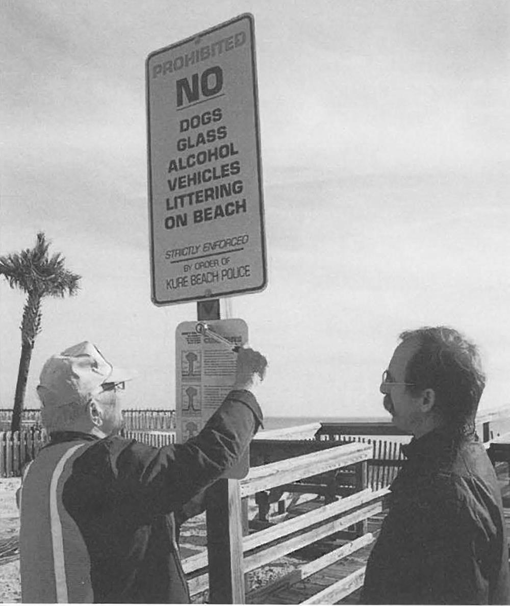
More than 500 rip currents safety signs are now posted along the North Carolina shoreline. Photo by Doug Smith.
“We have so many more people visiting the beaches, but the number of fatalities has not increased — in fact, it is going down,” says Sandy Sanderson, Dare County’s emergency management director, who cites a “chain of successful education efforts.”
A new link in the chain is the posting of more than 500 rip current signs at beach parking lots, crossovers, lifeguard stands and other sites. North Carolina Sea Grant is spearheading the project, in conjunction with local officials and the National Weather Service (NWS), part of the National Oceanic and Atmospheric Administration.
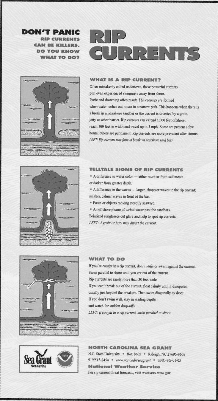
Rip currents are found not only along the ocean shoreline, but also along the Great Lakes. The rip currents form when water rushes out to sea in a narrow path. Often they form in a break in a nearshore sandbar, or near a groin, jetty or pier. Swimmers or waders who are unaware of telltale signs of rip currents may get caught in the strong pull.
“I think we have made tremendous progress in educating the public — but it is an ongoing education process,” Sanderson says.
Thomas Best agrees. As fire marshal in North Topsail Beach, he came to Sea Grant last year with a request for aluminum signs as a permanent education tool. By this spring, his town had posted about 65 new signs, each about the size of a “No Parking” sign.
“We put the signs at the crossovers, where people have to step up. They have to see the sign,” he says.
Sanderson, Best and others up and down the coast have worked with Spencer Rogers, North Carolina Sea Grant’s coastal erosion specialist, and the Sea Grant communications team on a number of rip current projects, including a video, posters and a brochure.
Last year, North Carolina offices of the weather service began offering daily forecasts for rip current potential, a service patterned after a forecast scale developed in Florida through the work of NWS, local lifeguards and university researchers.
Soon, NWS will unveil its new online “portal” for rip current information: www.ripcurrents.noaa.gov.
And, beach communities continue individual educational campaigns on beach safety issues. Thus, it is a coordinated effort to get the word out regarding rip currents.
“The key message is: Don’t panic,” adds Rogers.
EQUAL CHANCES
A strong rip current can move at about three feet per second — as fast as an Olympic swimmer in a 50-meter sprint — according to Sea Grant researchers in Florida.
So, when it comes to rip currents, everyone is equal. “I have rescued people of all ages, all swimming abilities and all sizes. They all can get caught in a rip current,” Sanderson explains.
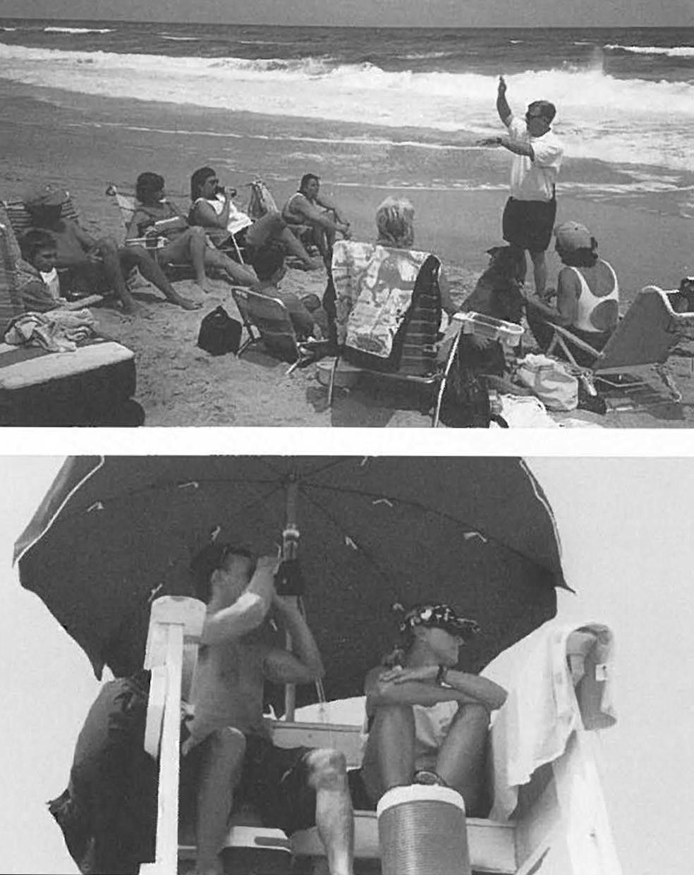
Kitty Hawk’s ocean rescue team provides safety lessons and monitors water conditions. Photos by Kitty Hawk Ocean Rescue.
The same is true in other beach towns. “Rip currents occur throughout the year, but the biggest problems are in tourist season — they (tourists) don’t know what to look for, what they can get themselves into,” Best says.
Each year, about 100 fatalities nationwide are attributed to rip currents — and overall, officials estimate that 80 percent of all ocean rescues by lifeguards involve rip currents. In fact, the U.S. Lifesaving Association annually tallies more than 22,000 rescues nationwide that can be linked to rip currents. That total may not include rescues by other beachgoers, police and rescue squads.
Best tells of one day a few years back, when five people on plastic rafts and other floats were caught in a rip current not far from Topsail Island’s northern tip.
While the rescue team members, each wearing a life jacket, were helping that crowd, another emergency was reported less than a mile away. So, Best headed to the second location.
“Nine people were in the water, making a human chain to help one person caught in the rip, but those at the end of the chain were getting pulled away,” Best recalls. “We gathered them and took them parallel to the beach.”
Swimming parallel to shore — rather than fighting the rip current —is a focus of the educational efforts. Most trouble spots are less than 30 feet wide.
If you cannot swim across the rip current, float calmly until it dissipates, usually just beyond the breakers — then swim diagonally to shore. “If you cannot swim, stay in wading depths close to shore,” Rogers advises.
Emerald Isle physician Arthur H. Hemmerlein recalls his family’s encounter with a rip current years ago: “My wife and son were on inner tubes, and suddenly they started heading out to sea,” Hemmerlein says.
“l went out to pull them back in, but I didn’t really know what to do. Luckily, we had something to hang onto.”
Later, when Hemmerlein saw Sea Grant’s rip current posters — with simple instructions and illustrations — he appreciated the direct message. He encouraged the Sea Grant office to transfer the message and graphics to a brochure that he could provide his patients.
Hemmerlein then purchased 5,000 brochures that have been given away by rescue squads and tourist locations throughout Carteret County. Overall, more than 50,000 Sea Grant tip current brochures have been distributed in North Carolina and across the country.
TURNING TO SCIENCE
A deadly series of rip currents in the summer of 2000 got the attention of Steve Pfaff and other NWS staff along the North Carolina coast. At least 10 fatalities were reported in the state that year.
Pfaff, who heads marine outreach efforts in the NWS office in Wilmington, knew of Sea Grant’s safety program, but he wanted to go further — to begin forecasting when conditions would be optimal for rip currents along individual stretches of shoreline.
He turned to Rogers and others for background on particular geological features of the North Carolina shoreline. And he looked to NWS offices in Florida and Sea Grant researchers at the University of Florida for factors used in rip current forecast models.
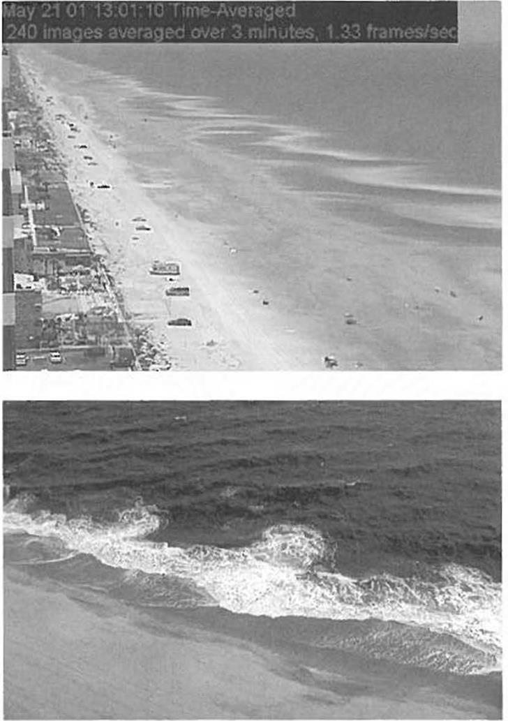
Rip currents can be identified in aerial views.
By Memorial Day 2001, the weather service had unveiled an online tip current forecast system for the Wilmington region that stretches from Topsail Island to Myrtle Beach, S.C.
In the Morehead City NWS office — which includes the Crystal Coast and Dare County — the rip current program is coordinated by Jeff Orrock and Mike Colby. In the Wakefield, Va., office — which includes Currituck County in North Carolina and the Virginia Beach area — the contact is Paul Houle.
“Town officials and county leaders are checking it daily, and the forecasts have become part of the television stations’ weather broadcasts,” Pfaff says.
“Even local papers are helping us spread the word when the threat for strong rip currents are high — and, along with other media outlets, they give NWS rip current forecasts more public exposure,” adds Pfaff, who received the Wilmington NWS office’s “Isaac Cline Award” for his outreach efforts.
The North Carolina models are derived from groundbreaking work done in Florida. Early work included forecasts by Jim Lushine of the Miami office of the NWS. Randy Lascody of the Melbourne NWS office transferred the models to other areas within Florida. Also, a team of Sea Grant rip current researchers at UF includes Bob Dean, Dan Hanes and Robert Thieke, as well as several graduate students.
“We used to believe that the formation of tip currents was relatively spontaneous and correlated with individual events such as large storms,” says Dean. “Now, we’re starting to believe rip currents persist for longer time periods at various strengths — sometimes as long as several weeks or months.”
Doctoral student Jamie MacMahan analyzed thousands of time-lapse images of a beach stretch near the U.S. Army Corps of Engineers research facility in Duck, on the North Carolina Outer Banks. He was able to correlate the images to wave data and other information from offshore buoys.
The images revealed dark swaths of the ocean, which the researchers describe as rip current channels that are persistent in time. As weather and surf conditions varied, the swaths expanded or shrank — but remained in the same general location even after most storms.
Only a particularly large storm or hurricane moved the channels — and/or erased the longshore sandbar system until a new tip channel formed. “We’ve identified some rip current channels that start in May and last until September,” MacMahan said.
While rip channels may be fairly common, they become noticeable — and dangerous — when the flow of water is sufficient to create a strong current, the researchers concluded. Factors include storms that push large amounts of water toward shore, piling water into the gap between the sandbar and beach.
“One of the biggest misnomers is ‘rip tide,'” MacMahan says. While rip currents are not part of the tidal system, they can be influenced by tides that lower the beach elevation.
The Sea Grant team also has found that when waves are breaking in a fairly solid line parallel to the shore, the risk for rip currents is higher than if the breaks come at a rippling diagonal toward shore. But if the angle of the breaking waves becomes too big, longshore currents may form, rather than rip currents.
To map the nearshore bathymetry — or flow of the ocean floor — along beaches in Florida, the researchers put instruments on personal watercraft and deploy the instruments in rip channels. Early this summer, the team will spend a month in Daytona Beach gathering additional data.
“We need more quantitative measurements, then we will be able to make better correlations,” MacMahan says.
SAVING LIVES
Sea Grant researchers have a simple goal in understanding rip currents and developing better forecasts. “To save lives,” says Dan Hanes, a co-investigator on the Florida project.
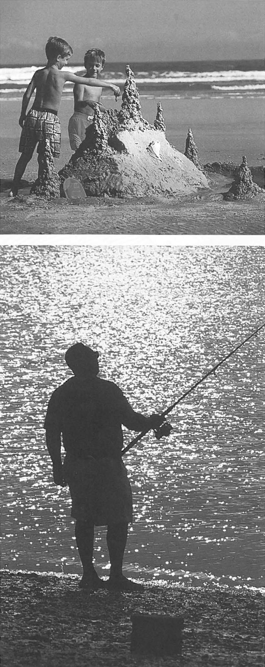
Even if rip currents keep beach visitors out of the water for the day, there are plenty of oceanfront activities available, including sand castle building and surf fishing. Top photo by NC Travel and Tourism. Bottom photo by Scott D. Taylor.
Thus, as Jason Engle, a UF master’s student, defines relationships between weather/wave data and rescue statistics, he shares the results with community groups, such as the Florida Shore and Beach Preservation Association.
“In Florida, rip currents, on average, kill more people every year than all other meteorological events combined — that includes hurricanes, tornadoes, lightning, etc.,” Engle says, citing NWS statistics. “We are looking to improve the rip current forecast scale used along East Central Florida.”
Although rescue team logs are qualitative descriptions of conditions by nonscientists, the researchers have found the lifeguard data to be quite accurate. “We listen to the lifeguards a lot,” Engle says. “And one advantage of using rip rescue data is that it is long term.”
In particular, he has found that in Volusia County, home to Daytona Beach, there is at least one rip current rescue every three days — and some days have 45 or more.
Similar research has started in North Carolina, though on a smaller scale. Lifeguards and rescue teams along the coast provide updates to forecasters to fine-tune the models. “It is very important to have close contacts with the beach communities,” says Pfaff.
Those contacts tallied seven rip current-related fatalities last year from Virginia Beach to South Carolina’s “Grand Strand” that includes Myrtle Beach. In nearly every case, the weather service had identified a higher than normal threat for rip currents, Pfaff says.
The North Carolina and Florida forecasting efforts are part of a nationwide push, he adds, citing a Spanish translation of the online rip current information by an NWS office in Texas.
Meanwhile, Rogers and other Sea Grant coastal processes specialists around the country keep each other updated on various projects. He cites Delaware Sea Grant’s efforts, including a training video and interpretive signs, as well as projects in Wisconsin and Michigan.
And, of course, the beach communities play an important role.
In January, NWS officials honored Police Chief Dennis Cooper of Kure Beach, who has rallied his town on beach safety issues including rip currents.
“We are building general awareness,” he says. “Kure Beach is a place where people come back year after year.”
For example, he wants visitors to know that rip currents often occur when lifeguards are not on duty — especially in the evening and after Labor Day.
“I want visitors to understand that when they step into that water, they are stepping into an ocean,” he says, emphasizing the grand concept of ocean.
“Once you jump into Mother Nature, you have to be aware. You have to be careful.”
Safety Message Makes Difference
Click photo to enlarge.
During the busy summer season, Cole Yeatts, Kitty Hawk’s director of ocean rescue, and his lifeguards take time to talk with visitors about rip currents and other beach safety topics.
And as Christina Lafex of Connecticut can attest — the messages are priceless.
Lafex admits she hadn’t paid much attention when Yeatts stopped to talk with her family in July 2001. While swimming that evening, she found herself trying to come back to shore — but she was caught in a rip current.
“I panicked at first because I was swimming as hard as I could, but kept getting farther and farther out,” she told The Coastland Times. “But then I thought of the words that Cole said.”
Just as Yeatts had instructed, she realized that she needed to compose herself and think about what to do. She remembered to swim parallel to the beach — and soon was clear of the rip current.
The next day, she looked for Yeatts to share her success story. If it hadn’t been for his chat, “I would be underneath the water right now,” she said.
Yeatts’ informal beach talks are combined with presentations at time-share communities and at the N.C. Aquarium at Roanoke Island. The town also has posted rip current signs and includes information on its Web site. Each part reinforces the basic safety message.
“It is very beneficial,” Lafex said.
Telltale Signs of Rip Currents
The following are signs that a rip current may be present:
- A difference in water color — murkier from sediments or darker because of greater depths.
- A difference in the waves. The rip current will have larger, choppier waves, while calmer waves are found closer to shore.
- Foam or objects moving steadily seaward.
- An offshore plume of turbid water past the sandbars.
Surfing the Web For Rip Currents
The National Weather Service is unveiling a new online “portal” to provide access to a variety of rip current information, including daily forecasts for various shorelines around the country. Web surfers can get general information on the homepage, or can plug in a town name or zip code to see if the weather service provides forecasts for that location.
The U.S. Lifesaving Association is another source of information on water safety issues. “A rip current is not an ‘undertow’ — it will not pull you under,” explains the USLA site on the Web.
Rip currents are not exclusive to the oceanfront. They are also found in the Great Lakes and the Gulf of Mexico. The National Park Service explains rip currents are found along Lake Michigan.
This article was published in the Early Summer 2002 issue of Coastwatch.
For contact information and reprint requests, visit ncseagrant.ncsu.edu/coastwatch/contact/.