By JUSTIN RIDGE
Justin Ridge is a doctoral candidate at the University of North Carolina at Chapel Hill’s Institute of Marine Sciences. His research focuses on optimizing oyster reef restoration in intertidal areas of North Carolina’s sounds. Ridge received a 2014 N.C. Coastal Reserve Fellowship from North Carolina Sea Grant and North Carolina Coastal Reserve to study oyster reefs near salt marshes. He has a bachelor’s degree in biology from Hanover College in Indiana and a master’s degree in biological oceanography from the Florida Institute of Technology.
Lugging a jackhammer across an oyster reef is like carrying someone over an uneven bed of nails. I have the scars to prove it. Yet, if you need to get a core sample from an oyster reef, there is no better tool.
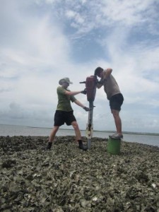
Justin Ridge, left, uses a jackhammer to core an oyster reef. Photo by Michelle Brodeur.
When I came to North Carolina in the fall of 2010 as a research technician in the lab of Antonio Rodriguez, a coastal geologist at the University of North Carolina at Chapel Hill’s Institute of Marine Sciences, or IMS, in Morehead City, I had never considered conducting research on oysters.
Rodriguez, too, had not originally anticipated working with the serrated bivalve. When he first arrived in North Carolina in 2005, if you had asked him whether he would be working with oysters, he would have laughed and politely said, “Definitely not.”
You would have received a similar response from Joel Fodrie, a fisheries ecologist also at IMS, when he returned home to Carteret County in 2009.
But just before I arrived, Rodriguez and Fodrie had joined fellow faculty member Niels Lindquist in an ambitious series of projects to examine oyster reef restoration on North Carolina’s coast. I found myself folded into these projects through a variety of jobs for each respective lab. Soon, I began to appreciate oysters for the benefits they provide to our estuaries and coasts, such as fish habitat, water filtration and shoreline protection.
I also witnessed firsthand the cultural and economic importance of the oyster fishery, which has become a shadow of what it once was.
• SPAWNING AN OYSTER STUDY
In November 2009, Fodrie and Lindquist visited the Rachel Carson Reserve, part of the N.C. Coastal Reserve and National Estuarine Research Reserve System, to examine restored oyster reefs. Some had been constructed with funds from North Carolina Sea Grant’s Fishery Resource Grant in the late 1990s. Lindquist, an oyster ecologist, was studying the reefs after finding extensive shell damage in Carteret County oysters caused by a sponge that erodes oyster shells.
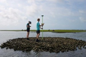
Elevations on a reef are measured using a very precise GPS. Photo by Emily Woodward.
The researchers noticed that certain reefs had grown very well since their construction, looking healthier than many natural oyster reefs.
“This sparked a number of questions,” Lindquist says, “like how these reefs were growing so well, and why a reef constructed just a few inches deeper would fail to grow oysters.”
To answer these questions, the team needed to accurately measure changes in elevation from reef growth. This requires precision-surveying tools not normally on hand for ecologists. Fodrie and Linquist turned to coastal geologist Rodriguez who had the tools and expertise to get the measurements they needed.
Although much of his previous work involved mapping changes to barrier islands and studying the evolution of river valleys, Rodriguez was intrigued. Few oyster studies have involved a geologist, making this a unique collaboration.
Later that winter, Rodriguez visited the reefs and took profiles of each using a specialized GPS able to determine elevations within a centimeter. It confirmed their suspicions that reefs constructed at shallower depths and on sandflats — as opposed to near salt marshes — had grown the best.
“By our estimation,” Fodrie says, “we were witnessing reef growth greater than previously recorded.”
What followed was a series of projects to answer why some of these reefs grew better than others.
When I first began working with Rodriguez, the team had recently obtained funding from the Albemarle-Pamlico National Estuary Program (now Partnership), or APNEP, to construct reefs based on elevations shown to be successful in the older restored reefs.
• BUILDING REEFS
In 2011, the three researchers with their small army of students and research technicians, of which I was one, built 32 new reefs within the Rachel Carson Reserve, part of the N.C. Coastal Reserve and a component of the National Estuarine Research Reserve System.
First, using a precision GPS attached to a backpack, we created a map of the tidal sandflats within the site by walking a grid over each of the reef locations. Then, using the profile data from the older restored reefs and water-level data collected from the same time period, we chose a range of elevations — spanning from shallow subtidal to low intertidal areas — to build reefs.
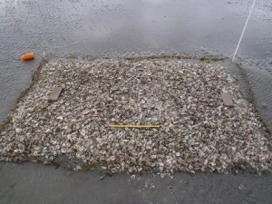
The team deposited shells to create 32 new study reefs in 2011, including this one. Photo by Joel Fodrie.
Sandflats are notorious for being dynamic features of estuaries because they are exposed to both currents and waves. As such, it is rare to see natural oyster reefs form in these less-protected areas. The decision, then, to construct reefs on sandflats was met with some skepticism.
“We were told by some people that we were just throwing shell away,” Rodriguez recalls. “That nothing would grow, and the shell we put out there would be washed away. From what we’d seen with the older reefs, we thought differently.”
The labor-intensive process of building the reefs took more than a month, even with the N.C. Division of Marine Fisheries, or DMF, transporting shell. After the shell was dumped, we spent days shaping the mounds into rectangular boxes by raking, shoveling and dragging a clam dredge across the loose shell.
Once we were finished, it quickly became clear that the team’s suspicion about reef tidal placement was accurate. Shallower reefs began to grow within the first year. Over the next few years, we watched as these shell piles exploded with life and became functioning oyster reefs.
“I think one of our most lasting accomplishments with our collaborative research was creating these reefs,” Fodrie states. “Now, they are monuments to what our labs can achieve together. And these reefs will continue to help us answer more questions about reef restoration in the coming years and perhaps decades.”
• MEASURING REEF GROWTH
While the reef building was underway, the team also began a two-year project to examine the growth of these reefs using a combination of coring and a method Rodriguez usually employs to measure beach change: a terrestrial laser scanner. It was for this project, funded by Sea Grant and DMF’s Coastal Recreational Fishing License Grants Program, that I learned how to use a jackhammer. We took core samples of the older constructed reefs using the jackhammer to pound aluminum pipe down through the center of each reef.
These cores were sectioned and processed in the lab to determine how high the reefs had truly grown since the original shell pile was placed. While the cores further confirmed that deeper reefs were not growing as well, it was the laser scan results that proved the most interesting.
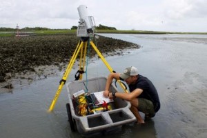
A terrestrial laser scanner creates a high-resolution map of a reef, allowing growth to be measured by stacking the digital maps from each year. Photo by Emily Woodward.
“I had never used the laser scanner to image a living structure,” Rodriguez recalls. “But when we saw the data come through, we knew no one had ever captured an oyster reef like this before.”
Using the laser scanner meant only being able to study these reefs in clear weather and at the lowest tides, usually occurring in winter and only offering us enough time to scan one or two reefs in one day. With approximately 30 reefs to measure using the laser scanner, it would take us the greater part of a year to collect all of the annual scans.
The laser scanner allows us to map a reef down to a centimeter. From the scan data, we can construct digital models of the reefs that allow us to compare entire reef growth over the course of the study.
“We were shocked by what the data showed,” Rodriguez says. “Previously, people thought oyster reefs could grow less than a centimeter a year. We found oyster reefs could grow up to 8 to 11 centimeters in a year.”
These results were published in a 2014 article in Nature Climate Change and are promising for future oyster restoration projects.
“There has been some debate about how oyster reefs will respond to accelerated sea-level rise. From our studies, it seems as if they’ll have a fighting chance,” Lindquist reports. “But it depends on where they reside in the tidal range.”
Many of these findings also will prove useful for implementing effective oyster reef living-shoreline strategies. “Having effectively created these really productive reefs where people worried they might fail has given us hope for implementing reef restoration in other places,” Fodrie declares.
“Considering what we’ve found, proper placement of material that oysters settle on at the right tidal elevation should produce a healthy reef in the high-salinity areas of estuaries,” he adds.
“This collaborative effort has provided valuable new information that builds on the decades of oyster research that has occurred. Learning that fine-scale differences in oyster cultch placement greatly impact the resulting success of the project will lead to enhanced oyster restoration projects and add constructed oyster reefs to our shoreline stabilization toolbox,” notes John Fear, former Reserve research coordinator and now deputy director of Sea Grant. Fear has been involved with the project team on these collaborative projects.
• MOVING FORWARD
Their success has emboldened this team of scientists to take on other restoration projects. Since building the reefs, we have constructed two more oyster sills. One spans the length of Carrot Island, also within the Rachel Carson Reserve. The other was constructed this past summer in front of the IMS shoreline, funded by UNC-CH as part of a green carbon initiative, and required nearly as much shell as the APNEP reef project.
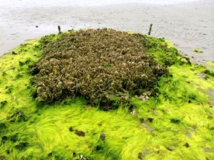
Two-and-half years later, the same location (see photo pictured above) now boasts a functioning oyster reef. Photo by Emily Woodward.
“Oyster restoration can be costly in both time and money, so projects that help make our efforts more effective are extremely beneficial,” says Craig Hardy, the lead oyster biologist for DMF. “I really appreciate how this diverse group formed a unique partnership in order to conduct crucial research that helps combat the demise of the oyster fishery and the loss of this critical habitat.”
This work also spurred my own research interests. I was awarded a 2014 Coastal Reserve Fellowship through Sea Grant and the Reserve. Over the past year, I have been conducting complementary research to examine how oyster reefs grow next to a salt marsh compared to isolated reefs on sandflats.
While the team members feel they have a much better picture of reefs in the Rachel Carson Reserve, they will continue monitoring these reefs in the coming years. They also are looking to explore these patterns in other areas beyond Back Sound.
Understanding how these growth patterns change with different tidal ranges and salinities tops their list of new questions. Fodrie, Lindquist and Rodriguez have completed another chapter in the ongoing restoration work on North Carolina’s coast, providing essential information to enhance oyster restoration projects.
This article was published in the Winter 2015 issue of Coastwatch.
For contact information and reprint requests, visit ncseagrant.ncsu.edu/coastwatch/contact/.