In addition to high wind, hurricanes, tropical storms and tropical depressions can produce life-threatening storm surge, heavy rainfall and flooding. According to the National Hurricane Center, 88 percent of all deaths in the U.S. from these weather events are a result of storm surge, rainfall flooding, high surf, and deaths just offshore (within 50 nautical miles of the coast). With Hurricane Matthew threatening the east coast, make sure you know what to do before, during and after the storm to keep you and your family safe from these threatening conditions.
This information is derived from the Flood Planning and Resilience Guide for Hyde County, North Carolina prepared by North Carolina Sea Grant, as well as the Prepare Your Property Before a Flood and Pack Your Emergency Supply Kit fact sheets.
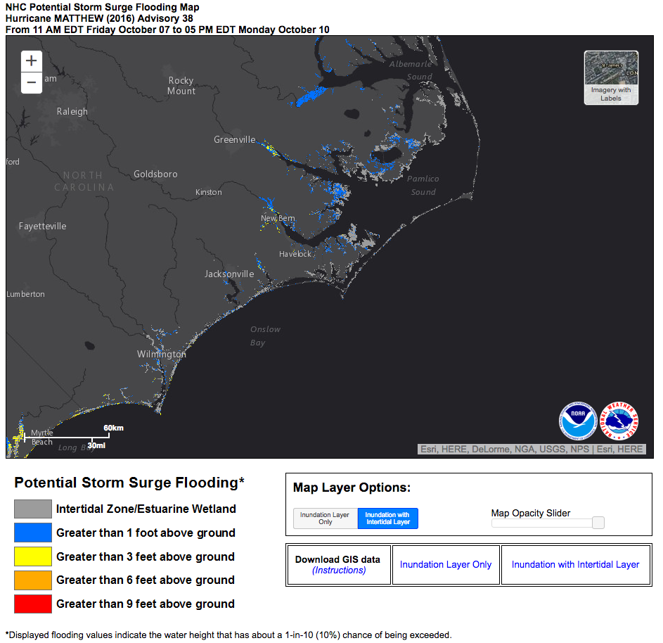
National Hurricane Center potential storm surge flooding map for Hurricane Matthew from 11 a.m. on Oct. 7 to 5 p.m. on Oct. 10.
During an approaching tropical system, find out how much water you could experience at your location by viewing storm surge inundation maps produced by the National Hurricane Center. You can find active storm surge inundation maps by going to nhc.noaa.gov and clicking on the tropical system that may affect land. Inundation maps are under the link for “Storm Surge Inundation” — view the potential storm surge flooding map for Hurricane Matthew.
Know the types of flood watches, warnings and advisories that the National Weather Service may issue so you know how to react in a timely and effective manner.
A flash flood is a rapid rise of water, generally over less than six hours, along a stream or low-lying area. It can be produced when heavy rain accumulates quickly, including from slow-moving or multiple thunderstorms occurring over the same area, as well as from dam breaks, levee failures or heavy rain.
Flash flood watch: Conditions leading to flash flooding are possible within the next six to 36 hours.
Flash flood warning: Flash flooding is occurring, imminent or highly likely within the next two hours.
River Flood Watch: River flooding is possible at one or more forecast points along a river.
River Flood Warning: River flooding is occurring or imminent at one or more forecast points along a river.
Areal floods are general floods over large areas of streets, low-lying areas, storm drains, creeks and small streams. They develop more gradually than flash floods, but still are a threat to life and property.
Areal flood advisory: Minor general or areal flooding is occurring, imminent or highly likely.
Areal flood warning: General or areal flooding is occurring, imminent or highly likely.
Coastal floods occur when seawater is contributing to flooding, including from overtopping or breaching barriers during tropical systems, nor’easters, storms or wind tides.
Coastal flood watch: Coastal flooding conditions are possible.
Coastal flood warning: Coastal flooding is occurring, imminent or highly likely.
New for 2016, the National Weather Service may issue storm surge watches and warnings in advance of an approaching tropical storm or hurricane when life-threatening storm surge may push water up on to land. Storm surge can and has affected both mainland Hyde County and Ocracoke Island, such as during Hurricane Irene in 2011. The National Hurricane Center will issue potential storm surge maps that show the height above ground that the water may reach, which will be available from the National Weather Service.
Storm surge watch: Possible life-threatening storm surge flooding within 48 hours.
Storm surge warning: Danger of life-threatening storm surge flooding within 36 hours.
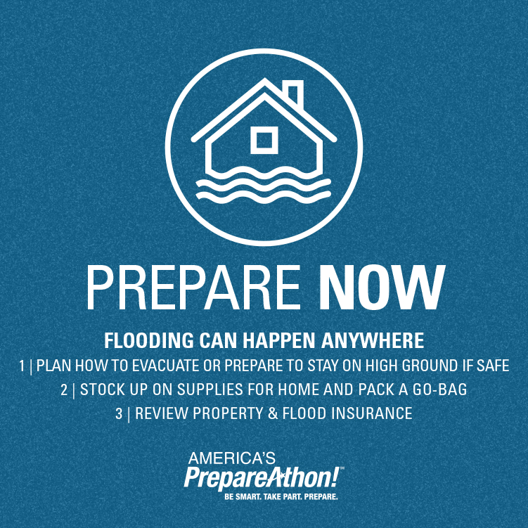
Flooding can happen anywhere, prepare now. Courtesy FEMA
Inventory the contents of your home to prove your losses to your insurer. Videotape or photograph all major household items and valuables. Then create files that include serial numbers and store receipts for electronics and appliances. Keep all records in waterproof containers and take them with you when you evacuate. For more information, ask your insurance agent.
Prevent or reduce flood damage by floodproofing your home. Consider elevating electrical components and major HVAC components at least 1 foot above the base flood elevation — and higher for additional peace of mind. You also may be able to elevate your entire home above base flood elevation, depending on the structure type and condition.
Prepare your property to reduce damage from flooding. Clear debris from gutters and downspouts. Anchor any outdoor fuel tanks. Move furniture, valuables and important documents to a safe, dry place.
A healthy floodplain helps floodwaters drain quicker and improves water quality. Help protect floodplains at your home and on your farm. Ensure that chemicals and fertilizers are stored as high as possible above the level of base flood elevation so they are not washed away. Dispose of unneeded chemicals and fertilizers properly. Do not dump them in drains, canals, lakes, ponds or impoundments. These can drain or be swept into local rivers and sounds.
Stock your emergency kit with basic supplies. For easy access, place as much as you can in a waterproof plastic tote to take with you, if you must leave your home.
Additionally, consider adding the following items to your emergency kit, if they apply to your family:
Preventing mold after a flood is a race against time. Have the following supplies available before a storm hits to help you recover and clean up your home:
In the event of a storm, local officials may issue an order — either voluntary or mandatory — to evacuate vulnerable areas. You can receive community evacuation information from local media and in some areas, through sirens, phone calls, social media, emails and text alerts. North Carolina Sea Grant recently compiled a list of national, state and local emergency contacts to help citizens of coastal counties get up-to-date information.
N.C. DOT maintains a map of evacuation routes for coastal North Carolina.
The amount of time you have to leave will depend on the storm event.If you have time prior to evacuating, disconnect utilities and appliances. Follow these guidelines for more tips on evacuating safely.
If you are evacuated, delay your re-entry until it is authorized or recommended by local authorities. Re-entry may be delayed due to flooding, polluted water, power outages, and other damage to a community. Some communities require a re-entry permit or form of identification. Please check with your local authority to determine what you need to bring with you during an evacuation for re-entry.
Avoid contact with floodwaters, especially for children and pets. Flooded septic drainfields may pose a health hazard, so always wear protective clothing if you must enter floodwaters and bathe as soon as possible afterward. Do not play or swim in flooded areas to avoid contracting illnesses.
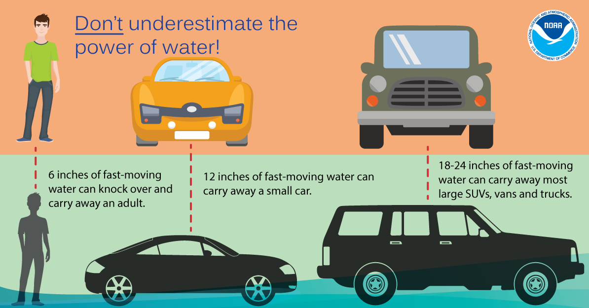
Turn around, don’t drown. Do not enter or drive through flooded roadways. In October 2015, swift-water rescues were necessary in mainland Hyde County when water swept vehicles into deeper canals along roadways. More than 50 percent of flood deaths are due to driving or walking in floodwaters.