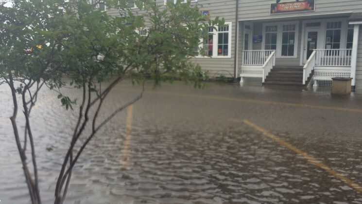
Above: Front Street in Beaufort, North Carolina, during a particularly high tide known as a king tide. Nuisance flooding causes such public inconveniences as frequent road closures, overwhelmed storm drains and compromised infrastructure. Photo by Christine Burns/NC King Tides Project, UNC-IMS
By Narcisa G. Pricope
Narcisa G. Pricope is a professor of geography and geospatial sciences at the University of North Carolina Wilmington (UNCW) and the North Carolina principal investigator for the Costs, Benefits, and Connectivity: Assessing Options for Flood Resilient Transportation Upgrades in Four Southeastern Coastal Communities Project. The project receives funding administered by North Carolina Sea Grant through the Karl Havens Memorial South Atlantic Regional Research on Coastal Community Resilience program.
If you live in coastal North Carolina, you’ve probably experienced flooding after a hurricane or even a short downpour. If you reside in a really vulnerable location such as the Outer Banks or tidal coastal watersheds, you’ve seen flooding even outside of a big storm.
Nuisance flooding — also known as sunny-day or high-tide flooding — is pervasive in the Southeast. In 2019, the region saw a 300% increase in nuisance flooding days compared to the year 2000, according to a 2020 report from the National Oceanic and Atmospheric Association. As coastal populations continue growing and flooding becomes more common, it is critical that residents can safely and swiftly evacuate and later return.
Yet, few municipalities have the resources or personnel to address existing problems or prepare for the future. “There are a lot of small and rural communities in North Carolina that don’t have staff with expertise in long-term resilience planning,” says Sarah Spiegler, North Carolina Sea Grant’s coastal resilience specialist.
In addition, thinking about and planning for resilience can often be overwhelming for communities, especially because they must balance the needs and concerns of multiple stakeholders and interest groups.
To help Southeastern coastal municipalities improve their resilience, my group at the University of North Carolina Wilmington has joined forces with several other states to design locally specific, cost-effective flood mitigation solutions, with a focus on transportation infrastructure. Our team includes scientists and partner communities from Florida, Georgia, South Carolina and North Carolina and is supported by the Karl Havens Memorial South Atlantic Regional Research on Coastal Community Resilience initiative.
The N.C. partner communities are the City of New Bern and New Hanover County, represented by their respective planning and resilience officers. We chose these locales for several reasons. They are both highly vulnerable to flooding, and I have a long working relationship with them. Also, they are at different stages in their resilience planning efforts.
For instance, New Bern is in the process of implementing a federally supported resilience plan. Meanwhile, New Hanover County is creating a stormwater database in order to begin resilience planning efforts. Working with communities at different stages allows us to learn what has already worked and what hasn’t, and to share these lessons with others.
One of the goals of our collaborative project is to assess possible gray and green infrastructure solutions for communities at risk for recurrent flooding. Gray infrastructure generally entails “hard” structures such as culverts, retention ponds, seawalls, roads, and dams. Green infrastructure, on the other hand, includes methods that incorporate or mimic the natural environment, such as permeable surfaces that absorb water, or landscaping that reduces runoff into storm drains.
Through our baseline assessment, we can evaluate the long-term costs and benefits of coastal planning efforts that entail gray or green infrastructure solutions. Nature-based solutions are more expensive to implement, but they promise a bigger return on investment over time. Indeed, they have lower maintenance costs and are more adaptable and resilient to a changing environment.
Coastal municipalities are keen to learn more about nature-based solutions. They recognize that proceeding with business as usual — such as building more gray infrastructure or simply elevating structures above flood level — won’t keep pace with rapid environmental and population changes.
So far, our researchers have conducted vulnerability assessments of transportation infrastructure in each of the five chosen communities. We considered road type and location; the length of time that roads were submerged during past hurricanes, such as Florence; and which roads would be inundated in the future under different sea level and storm surge scenarios.
Next, the groups will come together to share what we learned in order to identify which types of nature-based solutions will benefit each locale. Importantly, we also will hold a series of workshops to discuss our findings and prioritize solutions with relevant stakeholders from each community, including planners, utilities providers, non-governmental entities, and members of the public.
We anticipate that our four-state collaborative research project can be part of other efforts to prioritize nature-based projects that enhance resilience to flooding at the local, state and regional levels.