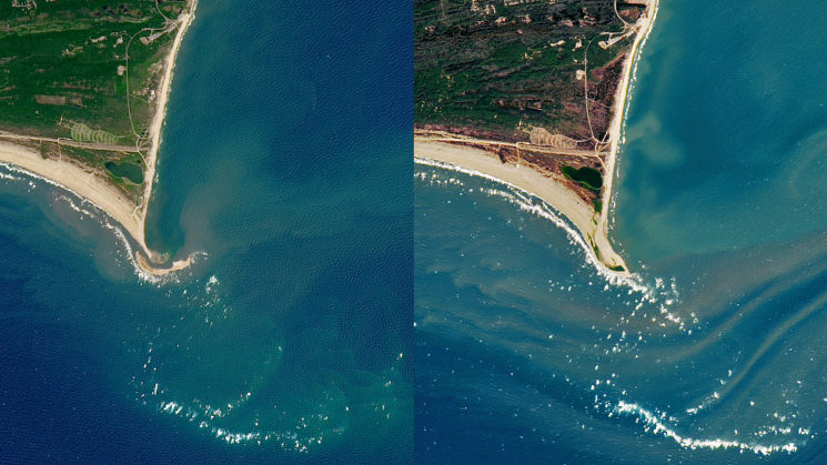
Images from NASA Earth Observatory, taken on July 7, 2017 (left) and February 16, 2018, reveal the dynamism of the Outer Banks coast.
The sea giveth, and the sea taketh away.
Last summer, a new shoal emerged off North Carolina’s Outer Banks. Known as Shelly Island for the abundance of seashells found on its shores, the sandbar captivated many beachgoers flocking to the Cape Hatteras National Seashore.
In recent months, however, Shelly Island has dispersed, as many experts predicted. Its short existence lasted about a year.
“Shelly Island no longer exists,” says Spencer Rogers, Sea Grant coastal construction and erosion specialist. “It has welded back to Cape Point, which we anticipated might occur.”
This dynamic behavior is not unusual for the coast, says Dave Hallac, superintendent for the National Parks of Eastern North Carolina. “It is not uncommon to see areas of barrier islands that are constantly and quickly affected by currents, wind and wave change.”
Gone with the Wind, and the Tide
Since its formation during early 2017, Shelly Island has been in flux. It accumulated sand during the mild summer, when fewer storms allowed it to grow. At one point in time, the sandbar was reportedly as large as 27 acres.
As the seasons changed, so did Shelly Island.
A record-breaking 2017 hurricane season saw Irma and José churning through the Atlantic and up the East Coast. In the winter, powerful storms dumped snow on the Outer Banks, which is unusual for the location. Together those conditions contributed to the coastal erosion that has eaten away at the island.
“The energy from tropical storms and hurricanes off the coast appeared to have redistributed the sand all around the Cape Point area,” Hallac says. “Large waves and strong currents associated with storms can rearrange the beaches along barrier islands in a short period of time.”
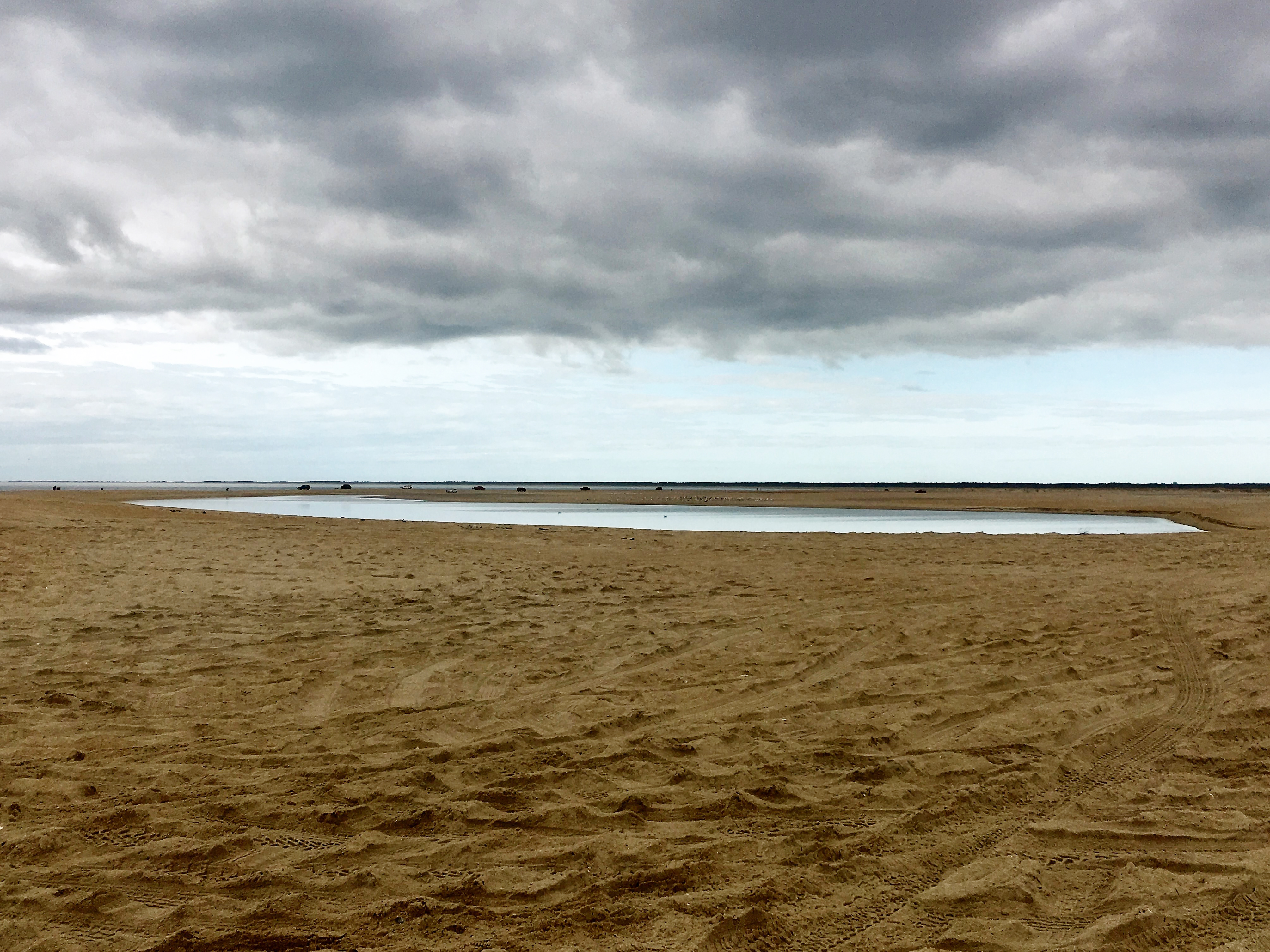
In January 2018, the only separation of Shelly Island from Cape Point was a small tidal pool. Photo courtesy National Park Service.
Over the course of the winter, parts of Shelly Island may have merged with the main beach. Some of the sand may also have drifted back onto the underwater shoals that contribute to the region’s legacy as the Graveyard of the Atlantic.
It’s unclear whether the island will make a reappearance.
Stan Riggs, a coastal geologist from East Carolina University who has studied the Outer Banks extensively, recently noted that current beach nourishment projects along the coast could allow for the creation of new sandbars.
“Buxton is in the final stages of pumping a very large volume of offshore sand onto the beach just north of Cape Point,” he says. “This project will result in a new source of sand for the nor’easters to redistribute.”
“As the high energy of this dynamic coast system surrounding the Outer Banks redistributes this new sand supply, there is a very high probability that it will allow new sand bars to form,” Riggs adds.
During its brief time above water, Shelly Island was known for its beachcombing opportunities. While that trove has sunken, Cape Point is still a prime spot to find seashells. Everything from daily tides to nor’easters — such as the one that could impact the East Coast later this week — continuously shape the geography of the coastline. Each beachcombing trip may bring new surprises.
If you’re planning a visit to Cape Point, remember to check with the National Park Service to get information about access ramps, weather conditions and four-wheel-drive permits.
Learn more about Shelly Island from the National Parks Service and NASA.
A version of this article was published in the Spring 2018 issue of Coastwatch.
NASA Earth Observatory images by Joshua Stevens, using Landsat data from the U.S. Geological Survey.
#