Natural Solutions and a Clean Water Future for the Cape Fear
With more people living in the Cape Fear River Basin and climate change bringing heavier rains, a new project is forecasting the effects of stormwater runoff as well as how strategic buffers can lessen pollution.
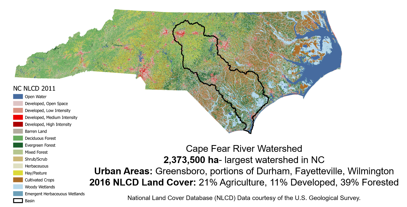
The Cape Fear River Basin — the largest of four watersheds entirely contained within North Carolina — is a lifeline for many communities, especially those along the coast. More than 6,500 miles of streams and rivers provide drinking water and recreational opportunities for millions of people living within the boundaries of the watershed’s 116 cities and 29 counties — from the urban areas of Greensboro, Durham, and Fayetteville to the coastal communities of Southport and Wilmington.
Unfortunately, with climate change accelerating, the Cape Fear River Basin and its natural resources likely will face more extreme flooding and droughts in the coming decades, exacerbating existing water quality issues that rapid urbanization and the expansion of livestock agriculture throughout the basin have created.
“Climate change is going to make everything more challenging,” says Katherine Martin, who leads the watershed ecology research group in collaboration with NC State’s Center for Geospatial Analytics and the Southeast Climate Adaptation Science Center. “The current models suggest that our precipitation events are going to become more extreme. We’re going to have more rain when it’s raining and then longer dry periods. That’s going to create challenges for water quality even if we maintain the land exactly as it is right now.”

Martin is working alongside Elly Gay, a doctoral student in the Department of Forestry and Environmental Resources, and researchers at The Nature Conservancy’s North Carolina Chapter on a North Carolina Sea Grant project to protect water quality in coastal areas throughout the Cape Fear River Basin.
Martin and Gay are using a series of computer models to investigate the effects of the forested areas surrounding water bodies — called “riparian buffers” — on coastal water quality. In particular, the researchers are examining the impact of placing buffers of varying widths in upstream locations where high concentrations of pollution are likely to overlap with increased development.
North Carolina already requires 50-footwide riparian buffers in some watersheds. However, fixed-width buffers aren’t always efficient in mitigating pollution because they’re not customized to the complex processes of each watershed.
“Riparian buffers are intentionally conserved or placed to benefit water quality and quantity,” Gay says. “Our goal is to see if we can maximize that effect by placing buffers with strategic widths in places that are at risk of declining water quality.”
A WATERSHED ON THE DECLINE?
Martin and Gay’s research comes at a time when the Cape Fear River Basin’s waterways face ongoing water quality challenges. The North Carolina Department of Environmental Quality (NCDEQ) recently designated nearly 100 waterways throughout the basin as “impaired” due to pollution. That includes more than 800 miles of streams, creeks, and rivers, as well as some 8,700 acres of lakes, reservoirs, shellfish growing areas, estuaries, and river mouths.
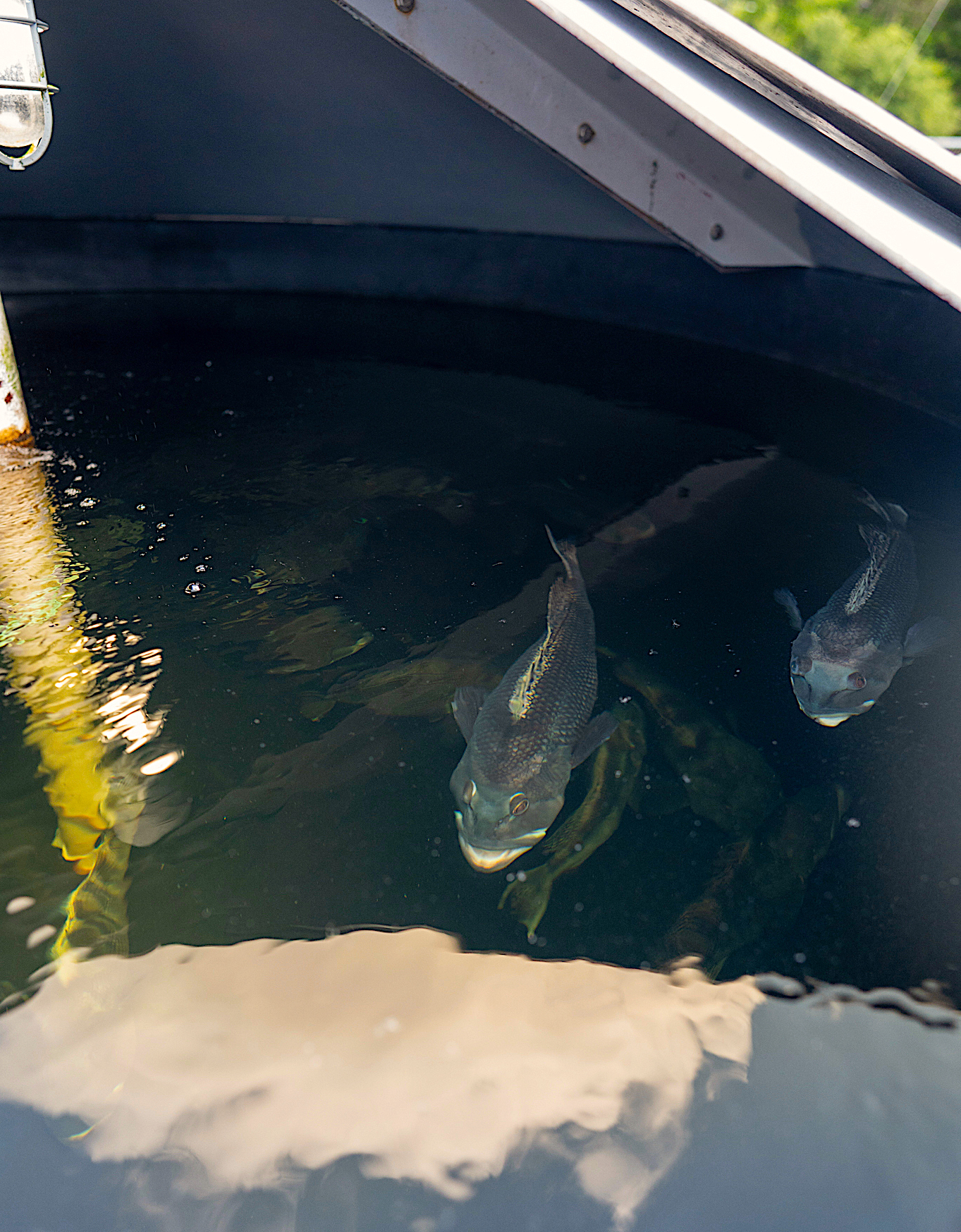
In addition to the unregulated and potentially cancerous chemicals that have been dumped into the Cape Fear River by Dupont and Chemours since the 1980s, some of the basin’s waterways contain an overabundance of sediment, nitrogen, and phosphorus. This can sometimes cause algae to grow faster than some waterways can handle — creating an algal bloom — and can reduce the oxygen in the water, killing large numbers of fish.
Local, state, and federal authorities closely monitor sediment and nutrient pollution, but it can still pose a serious public health threat if algal blooms contaminate drinking water sources. Algal blooms sometimes produce toxins that can cause skin rashes, liver and kidney damage, respiratory problems, and neurological symptoms. While most utilities have methods to remove these toxins, they’re not always a part of the standard water treatment process.
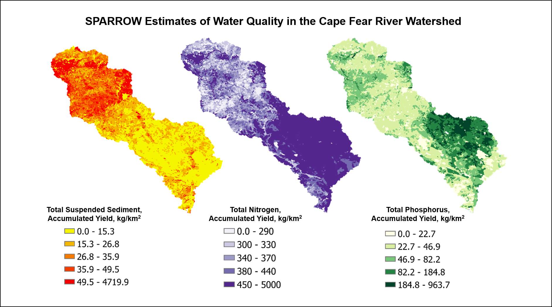
Using the U.S. Geological Survey’s SPARROW model, Martin and Gay discovered that the highest concentrations of sediment occur in the Piedmont, from Greensboro to Fayetteville, while the highest concentrations of phosphorus and nitrogen occur in the Coastal Plain, mostly in Sampson, Duplin, and Pender counties.
“Our hypothesis is that the sediment is primarily from urban development and the nutrients are from agriculture,” Martin said. “There are also different soils in the Piedmont that are more erodible than the sandy soils in the Coastal Plain,” which could contribute to higher amounts of sediment upstream in the Piedmont.
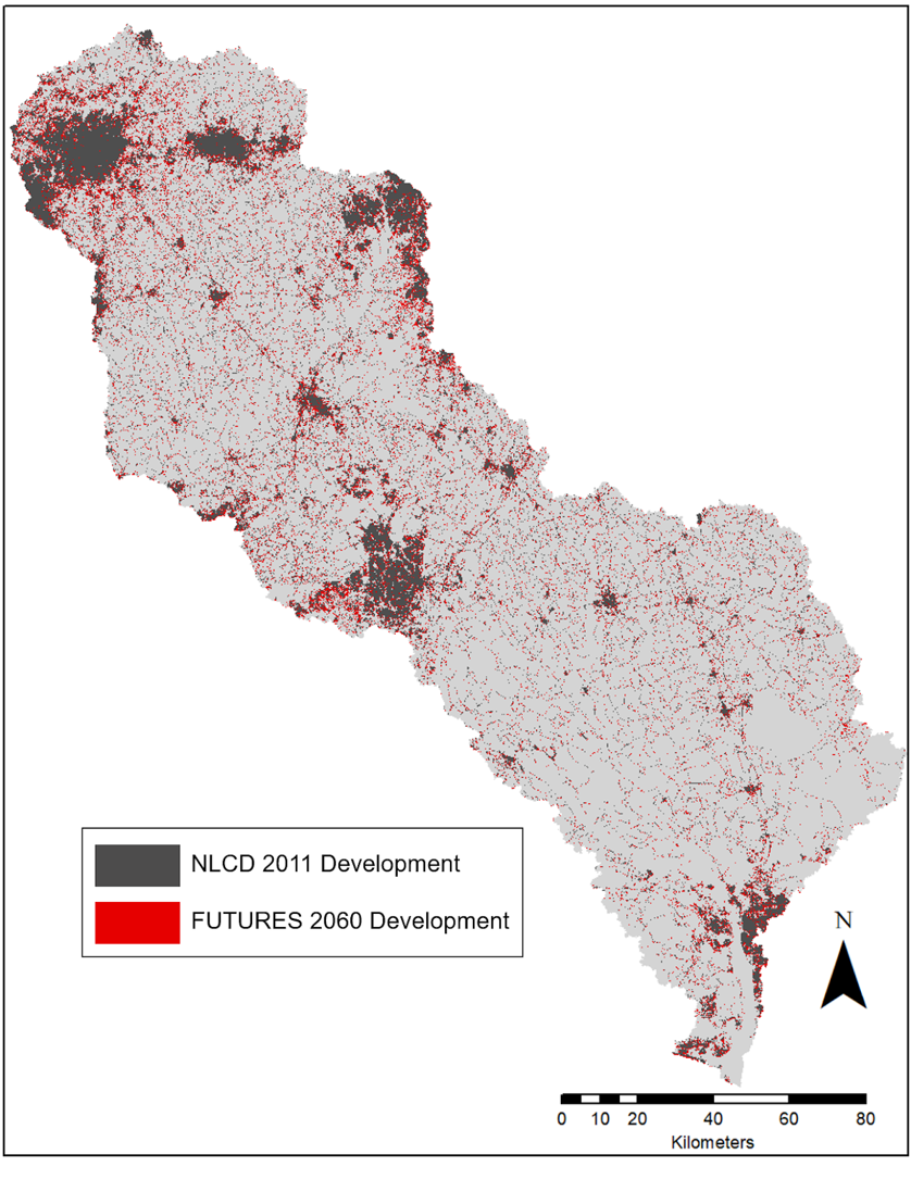
The Piedmont is rapidly expanding in the Cape Fear River Basin as many of its cities and counties transform rural land into urban infrastructure to accommodate growing populations. One projection shows that the region’s urban areas could expand by 165% through 2060. Unfortunately, heavy rainfall can erode exposed soils at development sites and then flush sediment into nearby waterways, according to Martin.
At the same time, Martin says, concentrated animal feeding operations (CAFOs) remain a primary source of nitrogen and phosphorus in the Cape Fear River Basin. These operations, mostly in Sampson and Duplin counties, discharge animal waste into open lagoons and then apply it on fields as fertilizer. When flooding occurs, the lagoons overflow and the fields become oversaturated, sending waste into nearby waterways. (For a look at how CAFOs burden underserved communities, see Lauren D. Pharr’s “Troubled Waters” in this issue.)
Climate change is likely to compound these existing water quality issues, according to Martin. In fact, the North Carolina Institute for Climate Studies expects climate change to increase the number of hurricanes passing near or over the state, bringing heavy rainfall that will in turn increase the potential for stormwater runoff. In 2018, Hurricane Florence alone caused several CAFOs to spill more than 7 million gallons of animal waste into the Cape Fear River Basin.
THE FUTURE OF URBAN EXPANSION — AND THE HOTSPOT AREAS TO ADDRESS
Martin and Gay now plan to use the “FUTURES” model, which researchers at the Center for Geospatial Analytics created, to simulate potential new development scenarios throughout the Cape Fear River Basin to better understand how upstream land-use changes could impact downstream water quality.
The Cape Fear River Basin covers more than 9,000 square miles across North Carolina and contains some of the state’s fastest-growing cities — the Wilmington metro area alone gained more than 5,500 new residents from 2020 to 2021. As of 2016, the basin’s total land cover consisted of 39% forests, 21% agriculture and 11% development. Martin and Gay’s preliminary analysis shows that development within the basin will increase to 14% by 2060.
“We’re concerned because there’s a lot of urban expansion happening in the watershed,” Martin says. “And while we want great places for people to live and work, the kind of growth we’re seeing doesn’t come without some trade-offs for water quality. When natural land cover is replaced with impervious surfaces, such as parking lots and sidewalks, it changes the frequency and volume of stormwater runoff so that it carries more pollutants into our waterways.”
Going forward, Martin and Gay plan to combine the data from their SPARROW analysis with the urban growth simulations from the FUTURES model in order to identify areas where water quality might be particularly vulnerable to sediment and nutrient pollution in the coming decades.
“These are the hotspot areas where we’ll likely consider simulating strategic riparian buffers to see if we can limit the effects of increased urban cover,” Gay says.
North Carolina’s coasts are extremely dynamic and important areas that also support the livelihoods of 20 counties, she adds. “Our hypothesis is that strategically placed riparian buffers upstream can benefit downstream water quality not only for watershed health — but also for these coastal communities.”
RIPARIAN BUFFERS AS NORTH CAROLINA’S NATURAL FILTERS
Riparian buffers are commonly established and maintained throughout watersheds to serve as natural filters against pollution from development, agriculture, and other land uses, according to Danica SchafferSmith, a project collaborator and watershed scientist for The Nature Conservancy. The trees, shrubs, and grasses within these buffers essentially slow the flow of stormwater runoff, trapping sediment and allowing polluted water to settle out over the ground.
“Nutrients like phosphorus are often bound up with that sediment,” Schaffer-Smith explains. “Ideally vegetation within buffers not only helps to block pollutants from getting into waterways, but also absorbs those nutrients as it continues to grow.”
In 1997, the NCDEQ established its riparian buffer protection program to maintain buffers along streams, lakes, ponds, and estuaries throughout the Neuse River Basin. The program has since expanded to include the Catawba and Tar-Pamlico river basins and the Goose Creek, Jordan Lake, and Randleman Lake watersheds. Both the Jordan Lake and Randleman Lake watersheds are located in the upper portion of the Cape Fear River Basin.
North Carolina’s buffer protection program recommends 50-foot-wide, two-zoned buffers: 30 feet of undisturbed vegetation adjacent to the waterway and an outer 20 feet of managed vegetation. While most studies show that wider buffers typically capture larger concentrations of nutrients than narrower buffers, the scale and placement of buffers required to improve water quality across regional watersheds isn’t well understood, according to Martin.
The Source Water Assessment Program characterizes both Jordan Lake and Randleman Lake, which provide drinking water for more than 700,000 residents across the Piedmont, as “highly susceptible to potential contamination sources.” Jordan Lake, in particular, has consistently experienced high levels of nutrient pollution over the years. Recently, multiple dogs died after exposure to an algal bloom while swimming at one of the lake’s boat launches.
Anna Gurney, a spokesperson for NCDEQ, says the agency’s riparian buffer protection program is part of a comprehensive management strategy for each watershed, with the agency adding waterways on a case-by-case basis. She says the agency has implemented riparian buffers when there was a legislative mandate to do so or when the agency identified “a clear necessity for significant measures, either to recover impaired waterbodies or as part of a protection strategy for listed species.”
Martin and Gay both say that determining the prevalence and effectiveness of riparian buffers in the Cape Fear River Basin is difficult, largely because most of the basin lies outside the state’s buffer protection program. However, under the regulations outlined in the Coastal Area Management Act, some coastal cities and counties within the basin incorporate setbacks in their development codes to ensure buildings maintain a minimum distance from conservation areas.
Once she and Gay identify areas where pollution and future development overlap throughout the Cape Fear River Basin, they plan to work with Schaffer-Smith to use the “Soil and Water Assessment Tool” to compare the effectiveness of 50-foot and 100-foot-wide riparian buffers.
“The model will help us understand what sort of improvements we can get if we implement these buffers strategically,” says Schaffer-Smith, who led the development of the tool for the Cape Fear River Basin during her time as a NatureNet Science Fellow with the Center for Biodiversity Outcomes at Arizona State University and The Nature Conservancy. “The findings will help us to do conservation and restoration in the best places.”
STRATEGIC SOLUTIONS, HEALTHY WATERWAYS
Research shows that the effectiveness of riparian buffers depends on a number of factors, including watershed size, regional geography and climate, present-day and historical land cover, the locations of pollution sources, and more.
For coastal communities in the Cape Fear River Basin, Martin and Gay believe that using buffers in smaller watersheds could significantly improve water quality throughout the southeastern part of the basin, an area with high concentrations of nutrients. If successful, Martin says, the strategic placement of riparian buffers could help cities and counties accommodate growing populations, adhere to state and federal regulations, and protect water quality.
The buffers also could reduce the cost to treat drinking water. One utility in the basin spends between $800 and $1,300 per day to treat algal blooms that sediment and nutrient pollution cause, according to NOAA.
“If we have forests on the landscape, the water going into the water treatment plants is cleaner to start with,” Martin says. “So there’s less need for treatment.”
Martin adds that the buffers could benefit North Carolina’s commercial and recreational fisheries, which depend on clean estuaries for nurseries for young fish. According to NOAA, the fisheries of the Cape Fear River generate nearly $14.2 million in income and $35.7 million in revenue, thanks in part to the wide range of commercially viable species available in the 35 miles of river between Wilmington and the Atlantic Ocean.
Additionally, the strategic use of buffers could ease concerns of some landowners and developers. “Right now, every person who owns a property near a waterway has to maintain that 50-foot buffer if they’re in a basin that’s part of the state program,” Schaffer-Smith explains. “If we’re able to place fewer buffers in locations where they have the greatest impact on water quality, there might not be as many landowners affected. It might also be a better use of taxpayer dollars.”
Ultimately, Martin and Gay’s work will provide policymakers and natural resource managers with the information they need to decide whether strategic riparian buffers are an appropriate solution for addressing the potential impacts of urbanization and climate change in the coming decades.
Martin says the findings could have implications for much of the Cape Fear River Basin. “The specialty of our research group is looking at future conditions and saying, ‘This is what might happen. Is this what we really want? Or do we want to try to do something different?’”
NC State collaborators include Ross Meentemeyer, Goodnight Distinguished Professor of Geospatial Analytics; Georgina Sanchez, research associate at the Center for Geospatial Analytics; Caroline Zuber, undergraduate research assistant in the Department of Forestry of Environmental Resources; Shannon McAvoy, doctoral candidate in the Department of Forestry and Environmental Resources; and Dominic Libera, postdoctoral researcher in the Department of Forestry and Environmental Resources. Other project collaborators include Julie DeMeester, water program director at The Nature Conservancy’s North Carolina Chapter, and Tatiana Height, founder of Height Environmental Justice and Planning.
READING AND RESOURCES
- Watershed Ecology Research Group
- The Nature Conservancy’s North Carolina Chapter
- North Carolina Department of Environmental Quality
- NCDEQ 303(d) Integrated Report Files
- U.S. Geological Survey Sparrow Modeling
- North Carolina Climate Science Report
- Waterkeepers Identify Multiple CAFO and Coal Ash Spills
- FUTURES Urban Growth Model
- National Institute of Environmental Health Sciences — Algal Blooms
- Centers for Disease Control and Prevention: Harmful Algal Bloom-Associated Illness
- Riparian Buffer Protection Program
- Source Water Assessment Program
- Soil and Water Assessment Tool
- Riparian Buffers as a Critical Landscape Feature: Insights for Riverscape Conservation and Policy Renovations
- Community Benefits of Conserving the Cape Fear River Basin
- Study — Cape Fear River fisheries account for $35.7 million in revenue
- Katherine Martin
- Danica Schaffer-Smith
- North Carolina Sea Grant’s funding opportunities
Andrew Moore is the marketing and communications manager at NC State’s College of Natural Resources. He primarily writes about faculty research for the college’s news site and other publications. Andrew previously wrote for Community Journals Publishing Group in Greenville, South Carolina, where he worked as a multimedia journalist. apmoore2@ncsu.edu
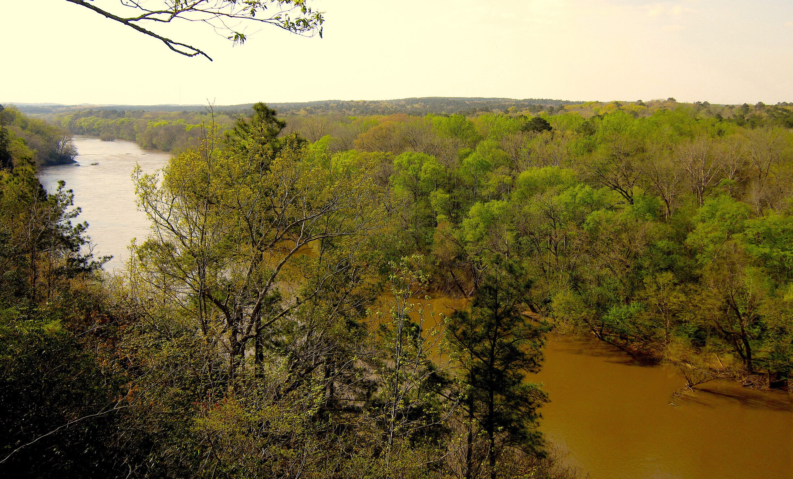
Lead photo: Upper Cape Fear River basin. Credit Selena NBH/CC-BY-2.0.
- Categories: