It’s not far-fetched to say that Kristen Lauren Hall knows the dynamic recent history of nearly every meter of Masonboro Island, a barrier island along the coastline in southeast New Hanover County.
To be more exact, Hall can track the undeveloped island’s shifting sand and changing profile through time at 500-meter intervals for its entire 8.5-mile length.
Masonboro Island is one of 10 state and federal sites within the North Carolina Coastal Reserve and National Estuarine Research Reserve System that are protected for research, education and coastal stewardship purposes. Understanding how the island has changed through time will help the NCNERR best manage it.
Hall’s template to measure change is a 1980 aerial photographic “map” of the island that she has divided into 24 reference transects, each 500 meters, or about 1,640 feet, apart. By overlaying a series of historic aerial images against this base map, Hall is able to show patterns and rates of shoreline erosion or accretion on the island from 1980 to 2010.
She chose the 1980 aerial photo as a historic reference point, she says, because a second jetty was completed in 1981 to help stabilize Masonboro Inlet. The first jetty was constructed in 1966. Images for study comparisons are based on a timeline of major events, such as storms, jetty implementation, inlet dredging and beach renourishment projects.
Hall began documenting Masonboro Island’s history of erosion and accretion cycles in 2010 while interning with the N.C. Department of Environment and Natural Resources’ Division of Coastal Management. She expanded her work for a research fellowship project she completed in 2011, with joint support from North Carolina Sea Grant and DCM’s reserve program.
“I wanted a way to look at long- and short-term changes as a result of storms, beach renourishment and inlet management through jetties and dredging,” explains Hall, who currently is pursuing a master’s degree in coastal geology at the University of North Carolina Wilmington.

“Mother Nature constantly is putting pressure on the island. The human response has been to engineer methods to counteract natural processes,” Hall says. The question remains whether human intervention and manipulation can match natural forces.
Masonboro Island, which became part of the NCNERR system in 1991, is sandwiched between two highly developed barrier islands: Wrightsville Beach to the north and Carolina Beach to the south. The Intracoastal Waterway laps the western shoreline of tidal flats, marsh and narrow beach strands. The Atlantic Ocean sculpts its white-sand beachfront to the east.
Hall’s study shows inlet management methods, beach renourishment and storm activities have exerted significant impacts on the shape and structure of the island’s shoreline.
More specifically, the island is heavily influenced by the sediment movement associated with Masonboro Inlet and its dual jetty system at the north end. The jetties hold Masonboro Inlet in place, but also contribute to sand loss on the northern face of the island. However, material dredged from the inlet to maintain the navigation channel is pumped periodically to fill in behind the jetty wall, to renourish the oceanfront beach and to maintain the dunes.
Meanwhile, frequent dredging of the Carolina Beach Inlet’s navigational channel has resulted in serious erosion along the southern sections of Masonboro Island.
In addition. Hall’s study documents how a series of 1990s hurricanes and nor’casters affected the island with overwash and erosion, especially in its low-lying middle and southern sections.
Hall also used LiDAR (light detecting and ranging) data to track the island’s elevations since 1996. Only six data sets were available for her study because LiDAR is a relatively new technology. The highest dune elevations recorded are on the northern end, where renourishment and dune-building occurs.
“Mapping changes on this dynamic barrier island is important because it allows us to understand how the island is changing and what habitats are most vulnerable,” says John Fear, reserve research coordinator.
THE BACKSTORY
Masonboro Island’s seemingly natural and undisturbed beauty belies its origins: As islands go, it is relatively new. Until the Carolina Beach Inlet was artificially opened by the U.S. Army Corps of Engineers in 1952, what is now the island was part of Carolina Beach.
And, as Hall’s study underscores, the completion of the north jetty (at the tip of Wrightsville Beach) in 1966 and south jetty (at the tip of Masonboro Island) in 1981 along Masonboro Inlet has significantly influenced the longshore sediment drift. The south jetty traps northerly moving sand, while southerly moving sand passing over the northern weir jetty is lost to the inlet channel.
“Kristen’s study gives insight into the impacts of nature and human actions on an undeveloped barrier island and how management strategies must respond,” says Hope Sutton, Masonboro Island site manager. “Habitat loss could be critical to the number of shorebirds and ground birds, loggerhead and green sea turtles.”
Additionally, the nutrient-rich tidal flats, marsh and waters of Masonboro Sound provide important nursery habitats for spot, mullet, summer flounder, pompano, menhaden and bluefish. Recently, Sutton’s naturalist’s eye has focused on the terrapin population on Masonboro Island. “It’s fascinating. It’s the only estuary-dependent reptile we know of, and it is a species of concern,” she notes.
Sutton points out that the results from Hall’s study could be extended to other sites. “We need to be thinking about how natural processes might impact developed barrier islands with roads, bridges, water and sewer infrastructure,” she adds.
Fear also envisions broader implications of Hall’s work. “Her project will help us understand how an undeveloped southern barrier island responds to climatic forcings. This baseline condition can then be used to help us understand how the influence of development on inhabited barrier islands alters the natural response. This will then help local barrier island communities make the best choices as they try to respond to future climate forcings,” he says.
Steve Rebach, Sea Grant’s associate director, agrees. “Regardless of the debate related to climate change, it has become evident that we are losing coastline, be it to erosion, land subsidence or sea level rise. The islands in the reserve system are vulnerable and it is important to establish a baseline and to monitor change along our coast,” he says.
SANDALS IN THE SAND
For her completed research fellowship project, Hall painstakingly pored over maps, charts, photographs and past research reports from myriad sources, including DCM, U.S. Army Corps of Engineers, N.C. Department of Transportation, National Weather Service, New Hanover County, Sea Grant and numerous university studies.
“Mostly, the research and analysis involved hours upon hours in the computer laboratory,” Hall explains.
But that has changed. Now, it’s sandals in the sand, with Masonboro Island as the laboratory for her master’s research she’ll conduct during the 2011-2012 academic year.
“Kristen will relate short-term patterns she documents in a year’s time to historic long-term patterns in shoreline change and island morphology, the baseline data from her research fellowship,” says Lynn Leonard, chair of the UNCW Department of Geography and Geology.
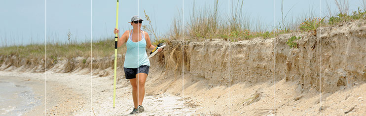
Hall already is laying the groundwork for her data collection. Using an RTK Trimble global positioning instrument, she is taking measurements at each of the original 24 transects to get up-to-date data on the slope of the beach, middle of the island and soundside. LiDAR imagery will help determine vertical changes in dune height.
She is placing sediment-trapping devices before the first row of dunes, on the dunes and after the dunes at each transect to capture sediment movement in ongoing conditions, and plans to check these devices once a month for a year, winter months included. She’ll coordinate her data with weather records to see how rain, wind or storms affect the settlement. She also will keep monthly records on the slope of the beach from the dune line to the tide line and changes in dune elevations.
With the new data, Hall hopes to plot elevation and erosion changes before and after storms of various categories that may hit the island. If she is able to determine the relationship between erosion patterns and storms, it would be a useful predictive model.
“The undeveloped Masonboro Island provides an excellent model to examine how a natural system responds to various coastal management activities, as well as natural processes,” says Leonard, a geologist, who helped Hall design her fellowship research and continues to mentor Hall in her master’s program.
Hall admits she is hooked on “all things Masonboro Island” and has been since she was a youngster. A Wilmington native, the island was her playground for as long as she can remember.
“I guess I came by my love for coastal geology naturally,” she says.
Her dad is Jack Hall, a geologist who chairs the UNCW Department of Environmental Studies. “I used to tag along with him on a lot of field trips. I guess it rubs off,” she notes.
Hall earned her undergraduate degree in marine geology from North Carolina State University and spent time mapping shorelines in Ireland.
During the summer of 2011, Hall had double the reason to be on Masonboro Island. She worked with Sutton as an intern, walking the beaches to check for turtle nests.
INVESTING IN THE FUTURE
Student research is an important part of the university life, Leonard notes. “Applied learning is a key focus of the UNCW learning experience. Research projects such as Kristen’s provide the students with unique opportunities to integrate the knowledge gleaned from formal coursework to evaluate arguments and solve problems in a field or laboratory setting,” she says.
Research opportunities also challenge students to apply scientific methods to address problems and questions in their discipline, to relate findings to real-world situations and to effectively communicate their findings to a broad audience.
Collaborative alliances, such as the UNCW/DCM/NCNERR/Sea Grant partnership, are essential to translating scientific results to those groups who develop, implement and even enforce coastal management policy, she adds.
“We hope Kristen’s research fellowship and follow-up master’s research findings will assist the reserve in developing ongoing coastal management strategies that help preserve Masonboro Island,” Leonard says.
The collaborative support of Hall’s research fellowship by Sea Grant and NCNERR is an important investment in the future, according to Sea Grant’s Rebach.
In fact, the 2010 partnership arrangement has become a model for fellowship programs initiated through Sea Grant programs and the National Oceanic and Atmospheric Administration’s National Estuarine Research Reserve sites in North Carolina, South Carolina, Georgia and Florida. Funded projects focus on specific reserve site needs.
“Sea Grant has a strong tradition of funding both graduate and undergraduate students in all areas of coastal research. We believe it is important to foster their education and provide the support to develop future leaders in the coastal sciences. These talented students often become involved in decision making and we believe it’s important to give them the tools they will need,” Rebach explains.
“It’s important for state and federal agencies to invest in student research because student researchers provide some of the best return in terms of dollars invested. Students are excited, energetic and typically willing to invest long hours to accomplish their project goals. On top of this, training the next generation of scientists is of paramount importance to maintain our great nation’s legacy of scientific leadership and achievement,” NCNERR’s Fear notes.
Hall definitely fits that model — and sees her future in the coastal sciences. “It is exciting to think that my research could eventually help coastal managers.”
This article was published in the Autumn 2011 issue of Coastwatch.
For contact information and reprint requests, visit ncseagrant.ncsu.edu/coastwatch/contact/.