A mile off Atlantic Beach, the crowd aboard the Crystal Coast Lady burbles with excitement. Eyes squint through viewfinders. Hands clutch camera phones.
Suddenly a rush of bubbles appears in the water and a hazard-yellow, loveseat-sized balloon bobs to the surface. From it hangs a 1-ton iron cannon lifted from the wreck of the Queen Anne’s Revenge, the ship the pirate Blackbeard used to wreak havoc throughout the Caribbean and along the Atlantic Seaboard from 1717 to 1718.
Three divers surface and begin hauling the load over to the crane of the R/V Dan Moore anchored nearby. The crowd cheers and cameras clatter as the 7-foot long cannon leaves the water for the first time in nearly 300 years.
TEACHING TOOL

“The treasure of shipwrecks of North Carolina,” says North Carolina State Archaeologist Steve Claggett, “is not the gold and the silver, of which there is almost none, but it’s the historical context and the opportunity by looking at wrecks — like the Queen Anne’s Revenge or Civil War blockade runners or World War II vessels — to flesh out the history of North Carolina.”
With its discovery in 1996 by the private research firm Intersal, Inc., the wreck of the Queen Anne’s Revenge has become a teaching tool. For visitors to the North Carolina Maritime Museum in Beaufort, where the artifacts of Queen Anne’s Revenge are housed, the ship brings to life an era of United States and North Carolina maritime history.
The wreck’s unique past, composition and placement have promoted the creation of new methods of archaeological research and recovery.
The Queen Anne’s Revenge project, known as QAR, is being undertaken and coordinated by the N.C. Department of Cultural Resources, Office of State Archaeology Underwater Archaeology Branch. North Carolina Sea Grant has worked with the archaeology branch to fund multiple projects that aid in the ship’s protection and conservation. One project employed a sand berm to protect the wreck. Another is testing the use of sacrificial anodes to preserve iron artifacts and begin the conservation process while they rest on the seafloor.
SHIFTING SANDS
For most of its history, the wreck of Queen Anne’s Revenge has been buried in the sand.
According to a paper published last year in the journal Historical Archaeology, the ship’s known career began as La Concorde de Nantes. It was a French privateer, or nonmilitary vessel with a mandate to attack an opposing country’s merchant fleet. During Queen Anne’s War, from 1702 to 1713, La Concorde sailed between Africa and the Americas.
After the war, the ship was reoutfitted as a slave trader. Three voyages between 1713 and 1717 transported slaves from West Africa to the Caribbean where they were sold. Sugar and other goods were then taken on board for sale back in Europe.

On Nov. 28, 1717, off the coast of Martinique, La Concorde was attacked and taken by a group of pirates that included Blackbeard. He renamed the 90-foot, 280-ton vessel Queen Anne’s Revenge and began a reign of terror that included a ship-taking spree off the coasts of the United States and the Caribbean. He amassed a pirate navy of four vessels and between 300 and 400 men, and blockaded Charleston, S.C.’s, port for nearly a week. In 1718, about a week after leaving Charleston, the ship ran aground and was abandoned near the mouth of Topsail Inlet, now known as Beaufort Inlet.
“In the past 300 years, it has only been uncovered two or three short periods,” says Lindley Butler, historian for the QAR project. “They happened to find it when it was uncovered.”
After the sand was swept away this last time, however, the wreck stayed exposed. A boon for those trying to locate it, lack of sand on the wreck has worried those who now are trying to conserve it.
Sand over a shipwreck buffers it from waves and currents. One of the first things archaeologists did at the site was to begin monitoring sand levels. They soon found that levels were dropping. The disappearing sand pointed to another question as well: How did a ship that drew 9 to 10 feet of water run aground in a place that is now 25 feet deep?
In 2001, then-mission director Mark Wilde-Ramsing approached Sea Grant with an idea to test a model that he and other project scientists thought might explain the discrepancy.
Previously, Sea Grant had provided funding for water-current and sand-level monitoring at the site. The team incorporated that data and others they collected using advanced bathymetry techniques into a scour/burial model that had been developed to determine the fate of naval mines.
Researchers discovered that the relatively few times that the wreck had been uncovered were because powerful currents, either from storms or from a shift in the placement of Beaufort Inlet, or both, washed over the site. These currents, the team believes, dug a hole or “scoured” out the leeward — or sheltered — side of the exposed objects.
The scour/burial idea is similar to the creation of a snow bank against a solid object in a snowstorm, explains Wilde-Ramsing. Like snow, sand will pile up against an object on the bottom “but on the lee side it will scour it out with these extra eddies like behind an 18-wheeler,” he says. The eddies cut “deep enough so that these objects will literally drop down until they become level with the surface.”
After the currents cease, sediment fills the holes and the objects are once again buried, this time at a deeper level than before.
To understand the wreck’s relationship to the inlet, Wilde-Ramsing and his team worked with marine geologists from University of North Carolina’s Institute of Marine Sciences, or IMS.
“We wanted to try and reconstruct the coastal setting, answering questions such as what did Beaufort Inlet look like, where were the sand shoals, and how had the inlet changed over time,” says John Wells, who previously was director of IMS and now is dean and director of Virginia Institute of Marine Science.
By comparing historical maps, bathymetry data and, more recently, aerial photography of the region, the team found that the mouth of the inlet had undergone extensive movement and changed orientation numerous times since 1718. They determined that the inlet had passed by the wreck — causing it to be in the channel and exposed to its currents — at least twice.

According to Wilde-Ramsing, the last time the wreck was in the channel was in 1927. In 1936, the U.S. Army Corps of Engineers stabilized the location of the Beaufort Inlet channel and dredged it for navigation. Wilde-Ramsing believes that at this time, 15 feet of sediment and 10 feet of water rested on top of the wreck.
Since the 1930s, the Army Corps has deepened and widened the channel, taking sand from it and depositing it further offshore. One hypothesis is that even though the channel is well away from the wreck, the dredging has removed sand from the system and made less of it available to cover the wreck.
By the 1980s, Wilde-Ramsing believes the 15 feet of sediment covering the wreck had been removed. Newly exposed and resting in nearly 25 feet of water, the wreck was waiting to be found.
After its discovery, sand levels on the wreck continued to decline. The wreck had come to rest on what researchers believe may be a prehistoric river or inlet bottom — a hard layer of sand more scour-resistant than the bar upon which the ship ran aground.
With the sand disappearing, Wilde-Ramsing again approached Sea Grant. This time, he had an idea to construct a wall of sand that might protect the wreck.
In 2006, the QAR team worked with the Army Corps of Engineers to deposit a sand berm approximately 400 feet seaward from the wreck.
“Because of previous Sea Grant work, we had the current data and knew enough about the site,” Wilde-Ramsing recalls. “We knew that the predominant direction was from the southwest to the northeast.”
The team hoped that the approximately 35,000 cubic yards of dredge spoil would dampen currents as well as be a source of sand that would gradually cover the wreck when it was not being excavated.
Funding from Sea Grant allowed the team to monitor the sand at the berm and at the wreck site. The team used multibeam sonar and physical measurements to determine the berm’s effect on the wreck. They found that sand from the berm was migrating onto the wreck, adding to the protective layer of sand.
“We had readings from early on and before we put out the berm — it looked like overall we had lost nearly 12 inches from 1997 and 2006 and in some storm-scoured areas, up to 3 feet,” Wilde-Ramsing says. “After the berm was put out and started working, we not only recovered the sand that was lost, but also gained about 8 inches to a foot.”
In 2011, the berm’s protection of the site was put to the test. Hurricane Irene hit the North Carolina coast as a Category 1 storm with sustained winds of up to 75 knots. Wilde-Ramsing and his team were anxious to see what it had done to the Queen Anne’s Revenge.
“Irene hit right there,” Wilde-Ramsing recalls. “There was some loss of sand but it wasn’t these huge scour holes that had been haunting us.”
The use of a sand berm is a new method for preservation of shallow-water wrecks. It proved to be effective and continues to be used to help preserve the wreck.
“It’s innovative,” Wilde-Ramsing says. “While this is a relatively unique situation, there are cases involving other historic shipwrecks where this would serve as a valuable protective measure.”
MAKING SACRIFICES
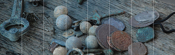
The cannons recovered by the Dan Moore are two of possibly 40 cannons that archaeologists believe the Queen Anne’s Revenge may have carried. They are “6-pounders,” the largest weapon in Blackbeard’s arsenal. Besides the eponymous 6-pound, nearly softball-sized cannonball, they would have hurled “langrage,” which are scraps of glass, metal and other pointy objects; bar shot or two cannonballs connected by an iron bar that spun, bola-like, snapping masts and crossbars; as well as “grape” and other small shot that allowed the cannon to function like a massive shotgun.

These cannons differ from other guns that have been removed from the wreck. They sport a foot-long zinc plate that conservators attached with a C-clamp. The rig is part of a Sea Grant-funded project that is testing the use of sacrificial anodes to preserve and restore large iron artifacts.
Corrosion is an electrochemical reaction where metals lose electrons to the environment and are gradually worn away. Sacrificial anodes divert the corrosion process from a valuable metal — in this case the iron artifact — to a metal that is more easily oxidized, in this case, the zinc bar.
“It’s low tech, but it’s high tech at the same time,” Claggett says of the anode strategy. “Boat owners use it to keep the hulls and engines of their boats from corroding. Some smart archaeologist said at some point, ‘Hmm, let’s try that on historical objects.'”
According to QAR Project Chief Conservator Sarah Watkins-Kenney, most of the pioneering work on using sacrificial anodes on underwater archaeological objects like cannons and metal hulls was done by scientists and conservators in Australia at the Western Australian Museum. Her team is testing whether attaching anodes to large iron artifacts on the Queen Anne’s Revenge can slow the rate of corrosion. They also are looking to see if the strategy is a viable option in the high-surge, low-visibility environment in which the wreck rests. In 2008, her team attached anodes to an anchor and two cannons. The two cannons that came up recently received theirs in 2012.
“If you’re trying to monitor what is still in the ocean as well as what has already come up, then this is a proposed technique to do it,” Watkins-Kenney says. “But is it something we can actually do? Is it worth the effort? That is part of what this help from Sea Grant is helping to assess.”
The answer so far seems to be both yes and no. Attempts to monitor the corrosion rate on the seafloor, which involves drilling a small hole through the layer of shell and sand attached to the iron and inserting a sensor proved to be too difficult to perform while underwater at the wreck site during the June field season.
But conservator Shanna Daniel is optimistic about some of the readings they have been able to get in previous years under more favorable conditions.
As she looks on, her teammate, Daniel Bera, uses a pneumatic drill to expose a small bit of the cannon’s metal, now resting in a trailer waiting to be driven back to the N.C. Department of Cultural Resources QAR Project Conservation Laboratory at East Carolina University. Conservator Kim Kenyon hands Bera what looks like a disposable pen connected by a wire to a monitor on Daniel’s lap. Bera inserts the device into the hole.
“We are measuring the pH and the electropotential,” Daniel says. “This will allow us to see if the anode is pacifying the corrosion or if it is actually making it active. … So far, what we’ve been seeing has been showing that it has been working.”
TOO MUCH SALT
Research from other wrecks suggests that anodes may help with another problem, besides corrosion, facing conservation of large iron artifacts. While on the seafloor, positively charged iron attracts negative chloride ions in the seawater.
Over time, the ions embed themselves deep within the iron. At high concentrations, they promote corrosion. If the artifact is allowed to dry while the salts remain, they crystallize, increasing in volume and fracturing the iron.

Currently, removal of the salts takes a lot of time and space. The QAR lab in Greenville is one of the largest marine conservation labs in the country. Yet, with 12 cannons and at least two anchors still to be recovered, its warehouse is nearly full with large iron artifacts going through the conservation process.
The first part of that process involves the concretion being removed from the iron artifacts. Concretion is a rock-hard coating formed as iron corrosion combines with elements in seawater and carbonates from shell deposited by marine organisms. Iron, a nutrient in limited supply in the marine environment, is attractive to sea creatures that wish to ingest some of it. Over long periods of time, the layer of concretion can grow to be inches thick and overtake surrounding artifacts.
Conservators X-ray the concretion to see what artifacts are inside. The X-radiograph helps guide conservators as they slowly chip away at the concretion using an air scribe — a tool like a powerful dentist’s drill.
Once most of the concretion has been removed, conservators can begin to extract salts from the iron, through a technique called desalination using electrolytic reduction.
This involves suspending the artifact in a tub of sodium carbonate solution and running a current through it to change its polarity.
The negatively charged salt ions are repelled by the now negative iron and migrate to positive plates placed around the edges of the tank. Conservators are able to estimate the amount of salt left in the iron by monitoring salt levels in the solution.
The process is slow. It can take years for the levels to drop from the hundreds of parts per million that are found in a newly recovered object to the 10 to 80 parts per million that are found in an object that is ready for display.
Research on other wrecks suggests that the use of sacrificial anodes attached to iron artifacts while they are still underwater may be able to reduce the time required for desalination by beginning the salt-removal process while the artifacts rest on the seafloor.
“The corrosion studies have turned out to be really interesting,” Claggett says. “We didn’t invent the process, but applying it here gives us a leg up when we finally do recover some of these large iron objects like cannons and anchors before they go to the lab. Before they even come off the ocean bottom, we start with this passive preservation with these sacrificial anodes.” While data from the iron artifacts attached to the anodes are still being gathered, Claggett believes they are a valuable part of the conservation process. “Rather than taking five or six or seven years to conserve a cannon for example, we may cut a year off of that,” he says.
“That’s worth a lot.”
IN SITU FIRST
A 2001 UNESCO Convention on the Protection of the Underwater Cultural Heritage recommends that managers of shipwrecks and underwater archaeological sites first consider in situ, or “in place,” protection before full recovery. The reasons for this are numerous. Even after treatment, the risk of deterioration remains. Museums often are not big enough to accommodate the large objects recovered from the sites. When a site has been fully recovered, its context is lost.
The biggest argument for in situ preservation, however, is the cost of full recovery. Because of its placement and historical significance, archaeologists decided that the Queen Anne’s Revenge wreck needed to be fully recovered. But as its removal has shown, full recovery of a vessel is an expensive and time consuming task.
For the vast majority of ships in the Graveyard of the Atlantic, even partial recovery will not be an option.
North Carolina Sea Grant-funded projects that have helped protect and conserve the Queen Anne’s Revenge may provide tools for managers trying to follow UNESCO’s recommendation of preserving shipwrecks where they lie.
This article was published in the Autumn 2013 issue of Coastwatch.
For contact information and reprint requests, visit ncseagrant.ncsu.edu/coastwatch/contact/.
- Categories: