FRIDAY, OCT. 15, 1954. The date is seared into the psyche of those who lived through what many describe as the most destructive hurricane event in North Carolina history.
Hurricane Hazel made landfall on that fateful morning at the peak of the highest lunar tide as a Category 4 hurricane near Calabash, at the North and South Carolina line. With winds as high as 140 mph and a storm surge up to 18 feet, Hazel changed the face of the coast — leveling dune fields and cutting inlets on barrier islands — as well as perceptions about hurricanes being purely coastal events.
Hazel’s rampage lasted another three days, roaring as far inland as Raleigh and Chapel Hill, and as far north as Lake Ontario on the Canadian border, still packing speeds of 100 mph in some places. Torrential rains flooded streams and rivers, adding misery and loss to Hazel’s destructive path. The storm finally weakened as it arced across Canada, raining itself out in the Maritime Provinces.

Though a teen at the time, Southport’s Jim Harper says, “I recall the sound of the wind and broken glass until this day.”
Harper, former editor and publisher of The State Port Pilot, would remember Hazel in his paper’s 50-year retrospective as “the most transforming event of the 20th century for this community.”
Days before coming ashore in North Carolina, Hazel swept over Haiti, where heavy rains caused massive landslides — taking lives, homes, businesses and valuable sugarcane crops.
While the mountainous island tamped down Hazel’s fury temporarily, warm surrounding waters intensified the storm. Early forecasts had predicted that Hazel would track offshore along the U.S. East Coast. But, by Oct. 14, she shifted course and headed for the Carolinas.
All told, Hazel claimed between 400 and 1,000 lives in Haiti; six in the Bahamas; 95 in the U.S., including 19 in North Carolina; and 81 in Canada. Its trail of destruction caused an estimated $350 million in property damage from the Caribbean to Canada. Those 1954 dollars translate to roughly $2.8 billion today.
Stories of death, destruction and survival emerged from a storm that took many in Hazel’s path off guard.
CALABASH RESILIENCE
Calabash, the small fishing village best known today for its distinctive seafood cuisine, first felt the impacts of Hazel’s landfall. Residents there recall their losses, but also manage to count their blessings.
For William Dixon, 15 years old at the time, the day began with bad news.
“I had planned to go hunting that morning, but Mom came in to say there would be no hunting. A bad storm was coming. Fishermen already were bringing their boats up into the canal in advance of the storm, so I stayed put. By 9 o’clock, the winds were howling and we sat out the storm in our house in the Hickman’s Crossing area,” Dixon remembers.
“When it was over, the shrimp house was gone, a three-mast schooner was sitting in our front yard, and we began to hear horror stories of people who died out on Ocean Isle,” he says.
Hazel took lives, property and livelihoods. “After the storm, people grabbed a hammer and nails and did what they could to make a living. Dad helped tear down what was left of the motel in North Myrtle Beach. In return, the owner let him take pine paneling and hardwood flooring. We managed to pull a house out of a pile of rubble,” continues Dixon, who later owned and operated a restaurant in Calabash. He now is a member of the town commission.
Now-retired Calabash commercial fisherman Samuel “Shorty” Thomas worked on his father’s 40-foot boat, Louise B, at the time. “The tide was so high, the boat sank at the dock,” Thomas says. “After the storm, we hauled her out of the water, repaired her and went back to fishing. Oddly enough, shrimping was better than ever after the storm.”
Salt water runs in his veins, claims Thomas, who operated tugboats for dredges up and down the southeast coast before returning to Calabash to resume shrimping for 10 years. Now retired, he opts for a rod and reel, and meets old friends every morning at Capt. Nance’s Restaurant “to see who can tell the biggest lies.”
Count on Anthony Clemmons to be at the table.
“Most in Calabash had never experienced a hurricane. We just didn’t know what to expect,” says Clemmons, who was about 14 at the time Hazel hit.
“My family went inland, where houses may have been sturdier than the rickety houses in Calabash, mostly built in the 1920s and 1930s and of uncertain storm worthiness. Surprisingly, our house and some of the old shack houses withstood the wind force and tide,” he says.
Clemmons recalls one Calabash shrimper, Capt. “Kinky” Coleman, who rode out the storm on his boat. Coleman told Clemmons that the Shallotte River looked like the ocean.
“As the eye passed and all got calm and quiet, he thought the worst was over. He looked behind him, and here came a big wave — Hazel’s other side. Somehow, Kinky made it through safely,” Clemmons adds. “Fortunately, no lives were lost in Calabash.”
It took Calabash more than a year to get back to normal — a new shrimp house, a new restaurant and one surviving oak tree left standing testified to the resilience of nature and people, Clemmons says.
Clemmons and his wife, Frances, returned to Calabash after he retired from a career in the U.S. Navy. A former town mayor, he is writing a book on Calabash history.
OCEAN ISLE TRAGEDY
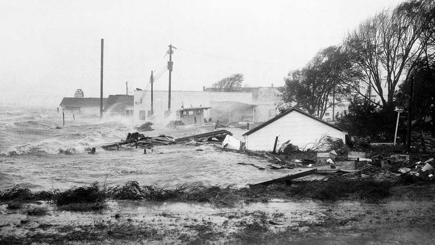
Brunswick County’s south-facing barrier islands, including Sunset Beach, Ocean Isle, Holden Beach, Long Beach and Caswell Beach, took the full brunt of Hazel’s 140 mph winds, 18-foot storm surge and treacherous waves.
For Ocean Isle, the loss was staggering. In just one incident, eight of the state’s 19 victims perished on the small barrier island across the Intracoastal Waterway, or ICW, from Shallotte.

Southport’s The State Port Pilot reported the tragic story of Sherman and Madeline Register, their 10-year-old son, Buddy, and their daughter and son-in-law, Sonja and Bunky Bellamy. The family had gathered for Thursday evening dinner at the Registers’ Ocean Isle cottage.
By 6 a.m. Friday, Oct. 15, with Hazel’s winds pushing onshore, it was too late to return to the mainland. The two-car ferry had stopped operating once its pulley cables went under rising waters.
Within two hours, winds exceeded 100 mph and angry ocean waters were advancing across the low-lying beach. Three couples from High Point, also stranded on the island, made it to the Registers’ cottage seeking help. In a last-ditch effort, all 11 of them piled into Sherman Register’s work truck to attempt the drive to the highest point on the island.
With winds reaching peak force by 10 a.m., their efforts were no match for the deadly storm surge that washed over the truck, dumping all 11 into the roiling waters. Seven were lost. Somehow, Bunky Bellamy, barely conscious, landed on a road west of the ICW; an unconscious Sonja Bellamy floated ashore elsewhere; and one of the three High Point couples survived.
The Oct. 20 edition of Southport’s The State Port Pilot editorialized that “by some miracle death was cheated” with their survival.
However, along with Sherman, Madeline and Buddy Register and the two High Point ouples, death claimed one more life: Southport’s Joe Dock drowned during his heroic, but unsuccessful, attempt to rescue the stranded Ocean Isle people by rowboat, the paper reported.
LONG BEACH SUCCUMBS
In the early 1950s, Long Beach was just becoming a destination for people who loved the beach, and good surf and pier fishing. With only a handful of pay phones on the island, it was a good place to “get away from it all.”
By October 1954, there were 357 houses on the beach. One of them was the newly completed “dream home” of now-deceased Sam and Mattie Carr and their 14-year-old son, Sam “Butch” Carr.
Butch Carr recalls, “We moved in just days before Hurricane Hazel struck.

Long Beach, now part of Oak Island, was beach sand, dirt roads and lots of maritime woods.”
Carr and his friend, Charles “Skeeter” Trott, learned of an approaching storm — and possible evacuation — after school on Thursday.
“Dad and my grandfather turned on the shortwave [radio] for a weather update. They were predicting that the storm would be 75 miles off shore. So, no one seemed fazed,” Carr remembers.
That is, until dawn on Friday when the family’s parakeet escaped its cage and woke Carr’s sleeping parents. By then, Hazel’s wind, waves and rain were pounding the shore.
“Our 1953 Buick wouldn’t start, so we drove our 1949 station wagon to my grandparents’ house. I kept watching the ocean rolling and churning toward the house. We heard the screen porch creek and begin to separate from the house.
We knew it was time to go,” Carr recalls. His grandparents, the late C.C. and Sadie Carr, built the first permanent residence on the island, part personal home and part boarding house.
“It was about 7 a.m. There were about four or five cars in our group — my grandparents, aunts, Ellen Gilmore (postmistress). The water was rising fast on the full-moon tide. We encountered standing water, but managed to get across the old swing bridge to the mainland,” Carr says. “We may have been the last people off the island before Hazel made landfall.”
They waited out the storm at Southport’s First Baptist Church, which had been turned into an American Red Cross shelter.
When Hazel passed, the family returned to Long Beach to search for remnants of their lives. “After the storm, everything was gone. We followed the debris field from where our house had been to the edge of the woods,” he says.
Looters had emptied one chest of drawers, but hadn’t discovered his mother’s cedar chest under a heap of rubble. Mattie Carr’s fur stole was inside — a bit damp, but not damaged. She hung it on a tree branch to air while the family continued searching for other possessions. When they returned, looters had stripped the fur stole from the tree.
The only clothes any of them had were on their backs, Carr says. “I wore the same clothes and my galoshes for a week until my cousins came from Goldsboro with clothes for us. My grandparents’ friend offered us an apartment.”
Carr’s parents, grandparents and aunts, now deceased, rebuilt their homes on Long Beach and moved back in 1955 — safely on the second row.
Carr graduated from Southport High School in 1959 and joined the Air Force. He and his wife, Susan, returned to the area in 1995 and reside in Boiling Springs.
SOUTHPORT SAFE HAVEN
Carr’s long-time friend and former island neighbor, Charles “Skeeter” Trott, also remembers the day vividly.
“It was the day before my 13th birthday. Not many of the families we knew were lucky enough to live year-round on Long Beach,” says Trott, whose late father, Charles Moore Trott, was a Long Beach real estate developer.
With news of the coming storm, the elder Trott sent his wife, Vida Hood Trott, and son to Southport with neighbors Charlotte and Robert Jones, and their young son, Butch. They were to stay with the Arrington family in what today is the Brunswick Inn, a bed and breakfast facing Water Street.

“My dad stayed behind, saying he needed to keep things safe on the island. He woke up before daylight on Friday with the house shaking,” Trott says.
The rising ocean washed away the family car and he was stranded.
Soon the Trotts’ home succumbed to forceful winds, and the two-story house next door blew — or floated — across the road. His dad found refuge in a house the wind had wedged into the woods across the island. There, he waited out the storm clinging to a mattress atop a refrigerator.
“After the storm passed and the tide ebbed, Dad began the 4-mile walk to the swing bridge that would take him to the mainland,” Trott adds.
Meanwhile in Southport, the storm raged. It was too dark to see anything. “When the eye passed over, Butch and I sneaked out to have a look,” he remembers.
The boys were stunned to see what the first wall of Hazel had done to Southport’s waterfront — fish houses, Harrelson’s grocery store and most waterside structures were gone. Boats were pushed up into yards and houses.
“The second eye wall bashed what was left standing and water pushed up into Bay Street and along the boat basin,” he says.
“The storm was scary, but not knowing what happened to my dad was terrifying.
Was he dead or alive? Southport was ravaged. What must have happened on the island? We feared the worst,” Trott recalls.
As soon as they were allowed, they headed to Long Beach. As they got to the bridge they saw a figure walking toward them. It was his father. Tears of relief flowed freely.
Like most residents on Long Beach, the Trott family lost most of their possessions. Remarkably, they discovered a corner china cabinet lying on its side at the tree line. Looters had taken the family silver, but the china was intact.
“Long Beach looked like a desert. The dunes were leveled and Hazel’s surge cut a temporary inlet through the island. Only five houses remained. We felt lucky, even though we lost so much. We came out of it alive,” he says.
Trott graduated from Southport High School in 1960 and soon began a 36-year career as an ammunition inspector at Sunny Point Military Depot. He married in 1962. “And, by the way,” Trott adds, “my wife’s name is Hazel.”
NEW HANOVER BEACHES HIT
More developed than Brunswick County beaches at the time, New Hanover County’s Wrightsville Beach and Carolina Beach homes and businesses were ripe for the taking by Hazel’s wind, surge and waves.
On Wrightsville Beach, Hazel wiped out oceanfront cottages, promoting second-row cottages to front-row properties. The iconic Ocean Terrace and Seashore hotels were destroyed and popular fishing piers washed away.
The causeway was littered with fishing boats that broke loose from their moorings and were driven inland by the relentless wind and waves.
Newspapers reported that 14 blocks of Carolina Beach were flooded during the storm, with 362 buildings destroyed and another 288 severely damaged.
KURE BEACH DASHED
Jean and Andrew “Punkie” Kure, now 85 and 87 years old respectively, say the ferocity of Hurricane Hazel took many Kure Beach residents off guard.
“It had been wonderful summer and fall seasons. Up to the day before the storm, fish were biting two at a time at the pier,” Jean Kure recalls.

They found themselves in the thick of evacuation plans by mid-afternoon on Thursday. Andrew Kure, volunteer fire chief/emergency manager, received word that the storm was fast moving, hard hitting and aiming at the Carolina coast.
He hustled his wife and six-year-old daughter, Linda, across the swing bridge to stay with relatives on the mainland.
The year-round population of Kure Beach at the time was about 100. But there were more than double that number of cottages and apartments in the burgeoning seaside community.
“I called the troops together — six volunteer firemen and one police officer — to begin knocking on doors to get people off the island. The wind was howling long before Hazel made landfall,” he explains.
“We continued to knock on doors until we were satisfied that everyone had left or was in the process of leaving. We received little resistance, except for one group of visiting fishermen who were intent on riding out the storm. We warned them that they were in peril, that neither they nor the cottage were likely to survive the storm. They sobered up quickly, packed up and left,” he says.
With warnings complete, Kure fought his way against the wind to retrieve his cat, Tom. They hunkered down with the rest of the crew in the church shelter to wait out the storm, listening to the sound of buildings being ripped apart.
There were some close calls, Kure points out. The bridge tender at the bridge over Snow’s Cut — a manmade canal that connects the Cape Fear River to Myrtle Grove Sound — reported seeing a house break loose and wash through the canal. When the eye passed and winds shifted to the opposite direction, the same house rode the rushing water back through. Somehow, the bridge was unscathed.
Hazel downed most oceanfront structures. The Kure Pier was destroyed and the pier house left on toothpick-like stilts. Five feet of sand covered U.S. 421 in most places.
The fishermen’s rental cottage? As Kure predicted, it did not survive Hazel’s fury — nor did the Kures’ own oceanfront rental properties.
“I had never seen anything like it before — or since,” Jean Kure says.
Her father, a lineman with the power company, worked day and night for weeks to reset power poles and lines downed by the storm.
“Everyone pulled together. The Red Cross and Salvation Army stayed for a long time with shelter, food and water. And the Health Department came to all affected communities to administer typhoid shots to prevent waterborne diseases,” she points out.
The day after Hazel, Andrew Kure, who had retired from the U.S. Marine Corps as a pilot not long before the storm hit, was asked to fly a plane for Jim Jeffries, a photographer with The Greensboro News and Record. They followed Hazel’s course along the southeast coast for an aerial survey of her destruction.
Sixty years later, Kure is still at a loss for words to describe what he saw. “It was hard to take in all that devastation,” he says shaking his head. “It was shocking.”
CARTERET COUNTY ON THE EDGE
Carteret County, some 120 miles north of Hazel’s landfall, was not spared the storm’s wrath. Surging waters flooded waterfront homes and businesses, including the landmark Sanitary Seafood Market and Restaurant, where John Tunnell, now 83, worked.

He remembers the early warning “of a big one coming our way,” heard through radio messages from ships at sea. Tunnell helped restaurant owner Tony Seamon Jr. prepare for the worst. “We lashed the building to pilings and cut holes in the floor to equalize pressure if the water came in. It came in all right,” he says.
After the storm, he helped the owners clean up. “We set up the Sanitary as a round-the-clock feeding center for work crews from as far away as Tennessee and Alabama doing cleanup in the area,” says Tunnell, who still reports for work at Sanitary.
Margaret Daniels of Williston, who lived with her family on Cedar Island in 1954, remembers Hazel very well.
“The wind was howling while we were eating breakfast. The house was shaking and the walls were swaying. Suddenly the chimney fell through the roof — right into my plate,” she says.
“In the middle of all this, a neighbor came by to ask if she could pick up the pears that blew off the tree in the high winds. Can you imagine that?” Daniels asks.
Natalie Willett Johnson, of Harkers Island, will never forget her wedding day to her late husband, Reis.
They were supposed to be married on Oct. 15 at the home of the groom’s aunt. It had been a whirlwind romance. He was 25. She was 18, spending the summer on Harkers Island before she was to begin her freshman year at East Carolina University.
“We fell madly in love and decided to marry before he entered the Coast Guard that fall,” Johnson relates. It would be a double wedding with Reis’ cousin Coreen and her fiancé Ronnie Chadwick.

On the day of the storm, the wedding party braved the treacherous wind to drive across the bridge to the aunt’s mainland brick home.
Of course, the preacher couldn’t make it. So, the couples married the next day. But when the storm washed out the North River Bridge, plans for a honeymoon in Beaufort or New Bern were dashed. Instead, the newlyweds — both the Johnsons and the Chadwicks — honeymooned at the Sea Level Inn.
After her husband’s Coast Guard career, the Johnsons returned to Harkers Island in 1969, where they resumed life as a commercial fishing family.
Down East fishing communities, including Sea Level and Atlantic, also suffered losses and close calls.
Mildred Willis Gilgo of Atlantic, who was eight years old at the time, recalls what happened to her father, Julian Willis. “My dad left the fishing grounds to get ahead of the storm. The current was cut off on shore early to prevent electrocution, and that meant there would be no lights on shore to guide him as he crossed the shoal. He would be in serious trouble,” she says.
The alert went out through the fishing community, and dozens of people lined up their vehicles along the shore, lights on, to guide him in safely.
“It’s the way we ‘neighbor up’ in a close community,” Gilgo observes. “If you choose a life on the water, you learn to be resilient.”
This article was published in the Autumn 2014 issue of Coastwatch.
For contact information and reprint requests, visit ncseagrant.ncsu.edu/coastwatch/contact/.