HURRICANE FRAN REVISITED: Lessons From a Benchmark Storm
The summer of 1996. It’s hard to believe it’s been 20 years.
Atlanta was prepping for the summer Olympics, DVDs were the new technology from Japan, and two new websites called eBay and Amazon were about to forever change the way we shop.
But for me, it was hurricanes Bertha and Fran that made the summer of ’96 so memorable.
At the time, I was living at the coast, my home tucked into the maritime dunes of Pine Knoll Shores just a few hundred feet from the Atlantic. When the wind was right, I could hear the thumping surf from my backyard.
Both hurricanes were born off the African coast — Bertha in July, Fran just weeks later in early September. I watched each one closely as they strengthened and churned westward, mindful of what they could mean for our coastal communities. Just a year earlier, UNC Press had released my first book, North Carolina’s Hurricane History, so I had added reason to monitor their every move.
I remember Bertha was no lightweight. Its arrival during the heart of the tourist season was most unwelcomed by vacationers and business owners from Myrtle Beach to the Outer Banks. Strengthening to Category 2 intensity before landfall, Bertha came ashore between Wrightsville and Topsail beaches on July 12, buffeting the coast with sustained 80 mph, Category 1 winds.
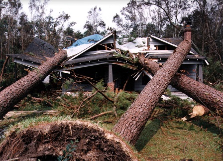
Pines snapped and tumbled, shingles flew, and many along the coast experienced the first hurricane-force winds of their lifetimes.
Many coastal residents from Wilmington to Morehead City who had moved into the area since 1960, or most born after that time, had probably never experienced sustained hurricane-force winds — 74 mph or greater — in their communities until Bertha.
I fit that criteria. I was born in Southport in 1958, lived in Carteret County after that, and Bertha brought the first true hurricane-force winds I witnessed.
The cleanup was still underway when Fran first appeared as a green swirl edging across our computer screens. Many whose property was damaged by Bertha worked hard that summer to rebuild their docks, patch their roofs, and haul away mountains of tree limbs and debris.
Their work was stopped in its tracks when it became clear that Fran would strike near Cape Fear as a stronger, Category 3 storm.
Ultimately, its inland course over farms, fields and cities would make Fran North Carolina’s most destructive storm to date.
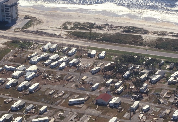
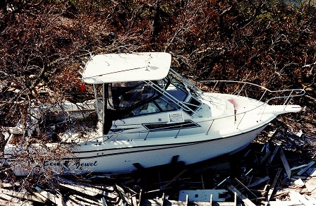
In its wake, many were astounded by Fran’s toll. New Hanover County beach towns experienced storm-surge flooding comparable to that of Hurricane Hazel, the gold standard for Tar Heel hurricane disasters. Winds gusted above 100 mph, pounding many of the same buildings, billboards and forests first punished by Bertha.
As Fran churned inland, rivers crested at record levels, fatalities quickly mounted, and the Triangle was hammered by a destructive hurricane for the first time in more than 40 years.
So few hurricanes made landfall here in North Carolina during the 1960s, ’70s, ’80s and early ’90s that Bertha and Fran were a wake-up call of sorts — reminding us how vulnerable we are to dangerous tropical cyclones. Looking back two decades later, it’s easy to let our memories of the ’96 storms blur with others that followed, especially Bonnie in 1998, and Dennis and Floyd in 1999. Floyd was, by any measure, another benchmark disaster for the state, causing greater damage and more fatalities than Fran.
But for many reasons, memories of Fran resonate.
“I guess to the layman, it looked like a bomb went off,” remembers Greg Fishel, WRAL-TV chief meteorologist in Raleigh.
As Fran’s core first approached the Triangle, Fishel wasn’t convinced the storm was going to be so destructive.
“We started seeing gusts of 50 or 60 mph, and that didn’t get my attention at first. We can have that in a severe thunderstorm. I don’t think we ever even recorded sustained hurricane-force winds,” he says.
“I was in the studio, and my wife called me and said, ‘Have you been outside?’ So we had the idea to broadcast out behind the studio. Well, my glasses blew off and my shoes filled with water in about a minute. It was just remarkable. And that destruction — it was the difference between one gust at 60 and six hours of 60 mph winds.”
Fishel notes that as a meteorologist, it’s important to understand not just how much wind and rain you measure, but the impact they can have on where you live.
“I learned a lot. I didn’t have an understanding of our soil type here in the Triangle. Afterwards, I talked to a professor at NC State, and he described it as ‘pancake batter.’ You didn’t see a lot of snapped trees here. They just came down, root ball and all.”
Being Prepared
A lot has changed in emergency management over the last two decades.
“I remember Fran well. I was totally unprepared for it,” recalls Mike Sprayberry, director of the state’s Division of Emergency Management, or DEM. At the time, he was a major in the Army National Guard.
“I was at home in Clinton. I left my wife and dog in the bathtub, and went to the armory. National Guardsmen know to head on in to work when the wind stops blowing.”
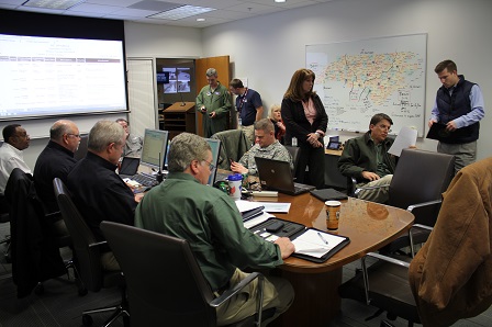
Sprayberry now oversees North Carolina’s disaster preparedness, response and recovery from the $53-million state Emergency Operations Center in Raleigh. Completed in 2012 with the help of federal stimulus funds, the center brings together emergency managers, the National Guard, and state-of-the-art communications for the N.C. Department of Transportation and Highway Patrol. It’s an impressive facility, and a far cry from the cramped, basement conference room on Jones Street that served as the operations center during Fran.
“We’ve come a long way since Fran. We’ve put in place so many programs and improvements. And there’s a lot of money coming in to make these happen — from the feds, from the state, Homeland Security. It’s a big investment. But it’s an investment worth making.”
Regional urban rescue teams, climate-controlled mobile operating rooms, new products for coastal storm-surge modeling and a mobile app — ReadyNC, which displays real-time evacuation information — are just a few of the division’s many initiatives in recent years. But according to Sprayberry, his highest priority isn’t in Raleigh.
“Around here, people know my mission statement: What have you done for the counties today?”
In North Carolina, county-level decision making is the model that works best, and DEM’s job is to be a good broker by providing tools and resources. That, combined with high-level coordination with volunteer groups — such as the American Red Cross, the Salvation Army and the Baptist Men — mean that future disasters will be met by well-trained and coordinated teams of responders.
Making Investments
In the years since Fran, other key investments are helping the state better prepare for future storms.
“The importance of pre-disaster hazard mitigation planning paid off in Kinston,” notes Gavin Smith, director of the Coastal Resilience Center of Excellence at the University of North Carolina at Chapel Hill. He advised Gov. Jim Hunt on long-term recovery in North Carolina after Hurricane Floyd.
One year after Fran, the state purchased 360 of Kinston’s most flood-prone homes, with another 600 acquired after Floyd. Eventually, this effort became one of the nation’s largest single-state acquisition programs.
“All told, the state acquired more than 5,000 homes and elevated another 1,000 following hurricanes Fran and Floyd,” Smith adds.
The Resilience Center, established in 2015 and funded by the U.S. Department of Homeland Security, comprises 22 universities and colleges throughout the country. The center conducts research and education for the next generation of hazard practitioners. Key research focuses on coastal infrastructure, building resilient communities and coastal hazards modeling.
Under Smith’s leadership, UNC-CH also established a graduate certificate program in natural hazards resilience.
Mitigation and resilience are more than just buzzwords for those working to keep us safe and protect our property. But how far can we go to reduce losses in the next big hurricane?
“In another storm like Fran, in general we’d see similar flooding,” warns Blair Hinkle, stormwater program manager for the City of Raleigh. “We’d hope that our upgraded infrastructure would reduce the duration of the flooding. Water that stood for four hours or six hours during Fran now might stand for only two hours. But most pipes and catch basins are designed to handle a 10- to 25-year flood. Fran exceeded 100 years, based on chance occurrence. It would be cost-prohibitive to try to design for the 100-year level.”
Like in Kinston, Hinkle notes that buyouts of flood-prone structures have been a focus for the city, reducing repetitive-loss claims. Another priority: upgrading Raleigh’s 75 to 80 nonregulated ponds — many of which overtopped or failed during Fran — by rebuilding dams to be taller and stronger.
Raising Structures
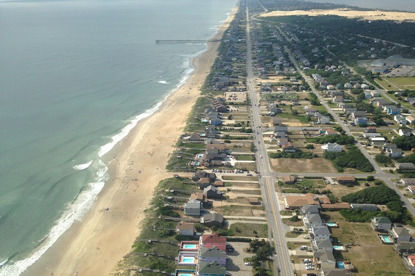
Along the coast, where populations mushroomed since Fran — Brunswick County’s, for example, has nearly doubled — local officials and planners know their communities remain vulnerable. Winds are fierce, but it’s storm surge from a major hurricane that poses the greatest risk.
“With Fran, we saw the highest water since Hazel in 1954,” says Spencer Rogers, North Carolina Sea Grant coastal construction and erosion specialist and a longtime New Hanover County resident. “And here on Whiskey Creek at the Masonboro Boat Yard, the marks from Hazel and Fran were very close.” The variation was much wider in neighboring Brunswick County.
Rogers, who has spent his career studying coastal dynamics and the structures built in the region, notes that one solution is pretty obvious.
“Building above the floodplain is required, but adding even more elevation helps.
Adding elevation is relatively inexpensive, depending upon how it’s done. The costs are often quickly repaid with savings on things like flood insurance.”
On a larger scale, elevating our beaches through sand nourishment is sometimes controversial public policy. But in the aftermath of Fran and Floyd, it proved effective.
“The hurricanes of the ’90s were a convenient test for beach nourishments. The performance was obvious during Fran — it was the higher test.”
Rogers explains that there are different scales of nourishment projects, two of which are designed projects that require regular maintenance. A third is sand disposal from navigation projects, where the goal is to find a place for dredged materials.
First, there are storm-damage reduction projects, such as those conducted by the U.S. Army Corps of Engineers in the mid-1960s in Carolina and Wrightsville beaches. Kure Beach was added in 1997 after Fran. The Corps’ design cross-section includes building beach and dunes, which are key to preventing storm surge, erosion and waves from reaching the buildings and infrastructure.
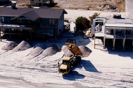
Next, smaller beach nourishment projects widen the beach to address long-term erosion, often paid for by cities, counties or the state.
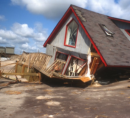
“Fran was a 120-year storm. The Corps design did what it was supposed to do. In Fran and Floyd, the dunes were consumed by design, allowing water to go through, but prevented erosion around buildings — the most likely cause of building failures. After Dennis and Floyd, there were 968 erosion-threatened structures in North Carolina, but none behind the projects in Wrightsville, Carolina or Kure beaches.”
Fran also tested building code changes for near-ocean buildings implemented in 1986.
The updated standards, which Sea Grant helped develop, significantly improved structures’ resistance to storm surge and waves.
This was apparent on Topsail Island where more than 97 percent of the newer buildings constructed after the code changes survived the storm. Of the 205 buildings identified as built after 1986, only five were destroyed. In comparison, more than 180 older buildings were destroyed in the same area.
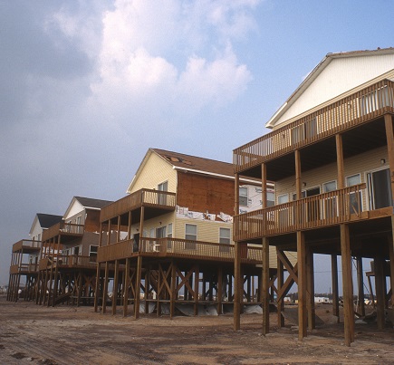
In addition, Sea Grant developed a piling-depth test that helped confirm that the surviving post-1986 structures that sustained damage were not built to code.
Even with the work that’s been done in North Carolina since Fran — the money spent, the mitigation efforts, the removal of flood-prone structures and the preparedness drills — we know the next great hurricane will test us again. So what can we expect when the next Fran or Hazel strikes?
“I think for a lot of people, it will catch them off guard, just like Fran did,” Sprayberry admits. “Preparedness is so important.
Sometimes, after time goes by, we see people develop ‘hurricane amnesia.’”
I think that’s all the more reason to reflect — and learn from the storms of the past.
Jay Barnes is the author of four books on hurricanes, and often appears on media outlets such as The Weather Channel, NBC Nightly News and The Discovery Channel. He is director of development for the North Carolina Aquarium Society. For more on Barnes, go to jaybarnesonhurricanes.com.
This is the second in a series about Hurricane Fran. Jay Barnes recalls the immediate impact and aftereffects of the storm in the Summer 2016 issue of Coastwatch.
This article was published in the Autumn 2016 issue of Coastwatch.
For contact information and reprint requests, visit ncseagrant.ncsu.edu/coastwatch/contact/.
- Categories: