MATTHEW’S LEGACY: WATER FALLING AND RISING

In North Carolina, Hurricane Matthew’s fury was the water, not the wind.
After leaving a thousand dead in Haiti, then moving up the South Atlantic coast, the storm’s outer bands arrived in the state on Oct. 8. But the full impact of the storm continued to unfold days after Matthew left the scene. Thousands of inland residents faced additional flood dangers as rain-soaked rivers swelled to overflow their banks.
Even though the storm’s center never made landfall in North Carolina, the statewide death toll was 28, claiming more than half of the total storm-related fatalities in the United States. Nearly all of the N.C. deaths were attributed to people being swept away in floodwaters while trying to navigate by car or foot, Gov. Pat McCrory explained at news conferences.
“Initial estimates show the economic damage of disruption to businesses, not accounting for economic activity generated from recovery efforts, is likely to exceed $2 billion,” McCrory stated in a letter to Congress. He requested more than $1 billion in federal assistance on Nov. 14. That initial request included $810 million for community, economic and infrastructure recovery.
“The height of the storm and the days following were very hectic as we responded to numerous calls for assistance in a compressed period of time,” recalls Mike Sprayberry, the state’s emergency management director. “The all-hands-on-deck response from our partners helped save thousands of lives, and helped people recover from traumatic situations — making the coordinated response well worth the effort.”
Matthew’s impacts have drawn comparisons to those of Hurricane Floyd, which devastated much of eastern North Carolina in 1999. After a twofold punch from Hurricane Dennis roughly two weeks earlier, Floyd’s heavy rainfall on saturated soils and brimming rivers resulted in massive flooding.
As Matthew’s torrential rain swept across central and eastern North Carolina in 2016, approximately 4,000 people initially sought refuge in 109 shelters opened by the American Red Cross in 33 counties, state officials report.
Despite various National Weather Service flood watches and warnings, thousands of other residents were caught off guard, finding themselves stranded in homes and vehicles.
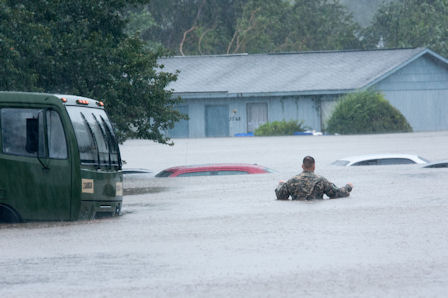
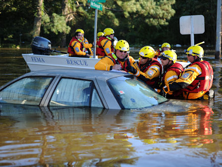
About 2,336 water rescues and 90 rescues by helicopter took place over the course of the storm and days following, state officials reported. More than 1,000 N.C. National Guard members assisted emergency responders, matched in number by state troopers. Water-rescue teams from across North Carolina and beyond aided efforts, along with neighbors bringing boats and other assistance.
The peak of the storm left approximately 635 roads inaccessible, the N.C. Department of Transportation reported. Floodwaters even reached to interstate highway systems, washing over portions of Interstate 40 and Interstate 95.
Of the state’s 100 counties, 49 were eligible for FEMA assistance by late November. N.C. public safety officials reported more than 75,000 applications for FEMA/state assistance, with more than $79 million approved to help those affected by the storm. More than 1,000 FEMA representatives were working on recovery efforts in the state.
Inland Inundation
Here is a quick look at several rivers and just a few of the inland communities that flooded across central and eastern North Carolina.
Cape Fear River
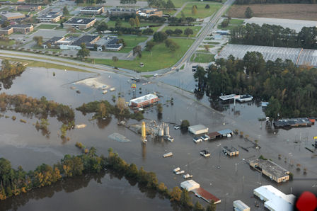
The sandhills region was still recovering from flooding rains one week earlier when Matthew brought nearly 15 inches of rain, setting the record for the area’s one-day total. On Oct. 9, the Cape Fear River in Fayetteville stood at 58 feet — more than 20 feet above flood stage. Rainwater washed away 11 dams in Cumberland County, as well as several smaller dams holding farm ponds in the region, surging water across roads and splitting the city into large islands. Major thoroughfares, including sections of Interstate 95, were flooded or had chunks washed away, along with more than 80 secondary roads in Cumberland County. Broken water lines, fallen trees and the loss of power at the water treatment plant compounded the city’s problems.
Lumber River
The closing of Interstate 95 in Lumberton, near the South Carolina border, drew a wave of national attention to North Carolina’s flood crisis. The city had received up to 10 inches of rain on Sept. 28. Then Matthew moved in Oct. 8 and lingered. During Matthew, areas within the Lumber River basin received 12 to 16 inches of rain. Near Lumberton, the river rose 4 feet higher than ever before measured. The water overtopped a levee running along the interstate and poured through an underpass into the city. The breach left 1,500 residents stranded, with many awaiting rescue on their roofs. Teams were forced to evacuate critical-care patients from the local hospital on Oct. 12. The water-treatment plant that serves nearly 22,600 residents also was inundated. Initially expected to be out until Thanksgiving, the plant was repaired in early November. The nearby river town of Fair Bluff in Columbus County also saw its downtown flooded and residents evacuated.
Neuse River
As streams filled, floodwaters flowed into the Neuse River, which runs from the Triangle region to the coast. In the week following Matthew’s rainfall, the National Weather Service predicted the river would rise to “dangerous flooding levels.” A gauge in Smithfield reported the river at a record height of 29 feet on Sunday, Oct. 9. Water poured over a dike at that city’s water treatment plant, threatening its main operations building before the river’s plume continued downstream. That Wednesday, it brought a record-high crest to Goldsboro, topping Hurricane Floyd’s levels by over a foot. By Friday, the rise topped Floyd’s records again — this time in Kinston, when it crested at over 28 feet, or 14 feet above the area’s flood stage. Just a week earlier, Matthew’s initial rainfall had caused flash flooding throughout the town, washing out U.S. 70 and filling homes and businesses with several feet of standing water. Kinston and surrounding Lenoir County had no time to recover before the river flooding. High levels of the Neuse also combined with flooding on Swift Creek in Craven County, including near Vanceboro. N.C. 43 partially collapsed near the Weyerhauser Plant, and West Craven High School was cut off by floodwaters for several days.
Tar River
In 1999, Hurricane Floyd’s floodwaters left Princeville underwater from the Tar River. Princeville rebuilt itself, including a levee refortified with a new dike standing at 37 feet. Despite those efforts, Matthew’s floodwaters again devastated the historic town — cited as the first settled by freed slaves. Initial heavy rainfall caused flash floods, forcing most of the 2,000 residents to evacuate. Nearly a week later, the swelling Tar River poured more water into the community. Road signs disappeared underneath waters as deep as 20 feet, guardsmen reported. Up to 90 percent of homes experienced window-level flooding, state officials added. For days, troops worked around the clock to drain water from behind the levee back into the river at a rate of 1.6 million gallons of water per hour, Edgecombe County officials reported. As Tar River floodwaters moved into Pitt County, Greenville city officials called for evacuations in targeted neighborhoods, and East Carolina University cancelled classes.
Coastal Impacts
Matthew’s impacts on North Carolina’s coastal communities included historic soundside flooding in villages on Hatteras and Ocracoke islands, and oceanside storm surge along the southern barrier islands.
In Dare County, locations from Frisco to Hatteras Village experienced soundside storm surge that equaled or exceeded that of Hurricane Emily in 1993, the benchmark storm of memory for many on the island. During Matthew, areas were inundated by water that was 4 to 5 feet deep in some spots, flooding many homes and vehicles.
During a Dare County Commissioners meeting after the storm, the rapid response by volunteer fire departments on Hatteras Island was highlighted. Not only did the firefighters provide emergency response, but they also went door to door after the storm to identify those who needed assistance, especially in areas with heavy flooding.
Ocracoke in Hyde County saw flooding of 2 to 3 feet above ground, which was higher than waters from Hurricane Alex in August 2004, the previous “storm of record.” Residents who had moved cars to locations where they had never observed flooding found their vehicles swamped by Matthew’s surge. Because Ocracoke is only accessible by ferry, a visitor evacuation order came on Oct. 5, with about 1,300 people moving off the island. Visitors returned Oct. 17.
Officials on some barrier islands reported damage to oceanfront dunes, including on Oak Island and Ocean Isle Beach, both in Brunswick County. “Many of those areas were known trouble spots,” notes Spencer Rogers, North Carolina Sea Grant’s coastal erosion and construction specialist.
New Tool Used
As Matthew approached the state, emergency managers were using a visualization tool improved by North Carolina Sea Grant research.
Casey Dietrich, a coastal engineer at North Carolina State University, visited the state’s Emergency Operations Center to see those partners in action. Their efforts included his new tool that improves the speed and ease of use of a storm-surge model known as ADCIRC, developed by a team led by Rick Luettich of the University of North Carolina at Chapel Hill.
The visualization product complements what the managers already use, Dietrich notes. “Our files are being combined manually with other datasets to determine the potential flood damages, in terms of both number and cost of buildings and infrastructure.”
Research to improve the presentation of ADCIRC tools also is funded by the U.S. Department of Homeland Security’s Coastal Resilience Center of Excellence, based at UNC-Chapel Hill, and the National Consortium for Data Science.
Long-Term Recovery
Eastern North Carolina knows by heart a lesson learned from Floyd’s floods: Recovery is a long-term prospect. Residents, along with government officials and the state’s Hurricane Matthew Recovery committee, expect a similar scenario moving into 2017.
By early November, FEMA agreed to begin providing manufactured housing as a temporary solution for the limited cases where no other solution is available. FEMA had approved nearly $50 million in financial assistance to help with home repairs or rental assistance and implemented a program to allow families to stay in hotels.
“Many people are still facing dire circumstances in our state,” McCrory said at a news conference. “We will continue to do all we can to help them recover.”
The governor also has noted that critical decisions for many communities would need to be made in a matter of weeks. In particular, there would be tough questions, such as if homes and businesses would be allowed to be rebuilt in some flooded areas.
After Floyd, some communities, such as Kinston and Greenville, had areas where properties within a floodplain were bought out, with that land converted into parks.
Partners in Planning
Other efforts will include longer-term planning. Sea Grant already has been working with several coastal communities to use tools and processes that consider the potential for increased flooding from storms, as well as other existing or anticipated conditions.
Along with assisting communities to identify existing vulnerabilities and consequences, Sea Grant has helped to explain how actions — such as raising homes, or increasing requirements for heights of living spaces in new construction — can limit damage from floods and also reduce insurance rates.
“As communities consider how to rebuild resiliently after Matthew, I anticipate that we will have requests from additional communities for training, including lessons learned from our demonstration projects,” notes Jessica Whitehead, Sea Grant’s coastal hazards adaptation specialist.
Whitehead and others on the Sea Grant team also are working with the National Weather Service to better understand the public’s perception of warnings and other storm-related information that forecasters provided to local officials and the public during Matthew.
Sea Grant used social media to help spread NWS messages of potential impacts before and during the storm, and regarding the extensive river flooding, notes Richard Bandy, who leads the NWS Newport/Morehead City forecast office. “The ongoing partnership between NWS and Sea Grant will help us understand how to better communicate the threat for future storms — a key to building a weather-ready nation,” he adds.
As executive director of North Carolina Sea Grant and the Water Resources Research Institute of the University of North Carolina, Susan White looks forward to both programs working with a mix of local, state and federal partners on topics related to Matthew.
“For example, WRRI may look at hydrology related to inland flooding,” she notes. “Sea Grant also may look at economic impacts, while continuing as a sponsor of the state’s annual hurricane conference with the N.C. Division of Emergency Management and East Carolina University.”
Ongoing coverage of Hurricane Matthew recovery efforts will continue in Coastwatch and on our blog. If you have a story to share, contact Katie Mosher at 919-515-9069 or kmosher@ncsu.edu.
This article was published in the Holiday 2016 issue of Coastwatch.
For contact information and reprint requests, visit ncseagrant.ncsu.edu/coastwatch/contact/.
- Categories: