A Brief History of Sea Level Rise in North Carolina
It begins with the birth of the Atlantic — millions of years before the recent acceleration of sea level rise from human causes — and it includes a long record of how people have responded to an encroaching ocean.
The story of accelerating sea level rise and its human impact unfolds on the most recent edge of a 200-million-year-old timeline. The longer tale begins with the birth of the Atlantic ocean, and it includes a record of how people have responded to the encroaching water for centuries.
Northeastern North Carolina’s coastal system embodies the best of water, wildlife, and wildness — an energetic, complex, and diverse waterscape superimposed on the geologic and biologic landscape. This landscape also is overlain with a rich but conflicted human history. The many different human groups inhabiting this world-class coastal system for millennia have witnessed the natural dynamics of change and left a cultural history based on these dynamics.
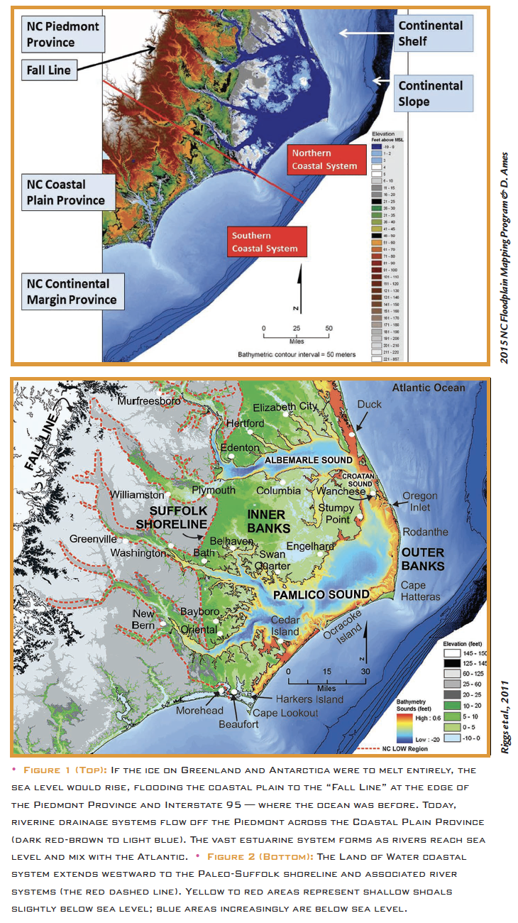
Where the western boundary of the vast Atlantic Ocean intersects the irregular topography of the North Carolina landmass today, a broad and shallow coastal system occurs (Figure 1). This land-water interface forms the modern North Carolina coastal system that is still dominated by and the product of energetic storms that build, maintain, and obliterate it; these are the forces that drive coastal evolution. The result is a complex network of diverse geomorphic features and associated aquatic ecosystems in which change is the only constant.
The wild and beautiful coastal system of North Carolina (Figure 2) has always had a magical draw for human occupation and, most recently, has become an essential component for ever increasing economic growth and development. However, continued expansion in a dynamic coastal system dominated by high energy storms and change has set economic growth and community development on a collision course with natural processes.
A new vision must emerge, one in which society adapts to and lives with the ongoing processes of dynamic change. This can only happen if society integrates scientific understanding with our cultural needs into a new paradigm for the “North Carolina Land of Water.” 1
Building North Carolina’s “Coastal Margin”
The North Carolina Coastal Plain is bordered on the Atlantic Ocean side by its drowned partner, the submarine continental margin, and on the inland side by the “Fall Line” that separates the Coastal Plain from the Piedmont and Appalachian Provinces (Figure 1).
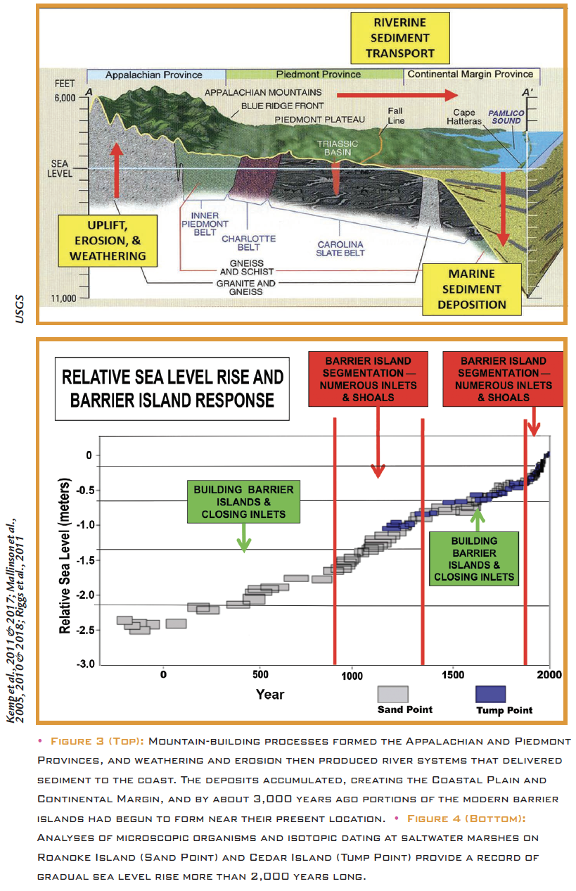
The Piedmont and Appalachians are ancient landforms resulting from severe mountain-building processes more than 250 million years ago. They have substantial elevation above modern sea level and are composed of ancient metamorphosed sedimentary rocks crystalline granitic and basaltic rock types. The Atlantic Ocean started to form about 200 million years ago and accumulated vast thicknesses of marine sediments, which range from a few feet at the Fall Line to 10,000 feet at Cape Hatteras, and to about 40,000 feet on the outer continental margin about 50 miles off the present barrier island system (Figure 3). This sediment wedge is composed of marine deposits and associated fossils (such as oysters, clams, mussels, corals, crabs, and shrimp) that today extend inland to form the Coastal Plain and that occur in part above modern sea level.
The topography of North Carolina’s modern Coastal Plain is the direct product of previous coastal systems as sea level rose and fell, causing the coastal system to migrate back and forth across the continental margin. The processes of climate change — fluctuations in sea level, ocean dynamics, and frequency and intensity of storms — dictated when coastal waters flooded or drained the river valleys, when shorelines advanced or receded, when ecosystems evolved or migrated, and when barrier islands moved landward or seaward.
The historical evolution of the ancient to modern coastal systems has been extensively analyzed and mapped, such that now these processes of change can be projected into the short term future with a certain level of confidence.1, 2
The Scientific Record of Sea Level Rise
Sea level rise by itself is a fairly slow and gentle process that is like filling a bathtub. The scientific record of sea level change in coastal North Carolina has been well established over the last 50 years by a vast array of coastal marine scientists of many different disciplines dissecting the North Carolina coastal system (Figure 4).
Sea levels have risen and fallen for as long as there has been an Atlantic Ocean along North Carolina’s eastern shore. Today, fossil beds of marine shells in our estuarine bluffs occur well above modern sea level. For instance, one such bed — full of finger corals, oysters, and articulated clams — is located about 10 to 15 feet above present sea level in the west banks of the Chowan River Estuary.3, 4 To produce this deposit, the relative level of the sea in the recent past must have been substantially higher than at present.
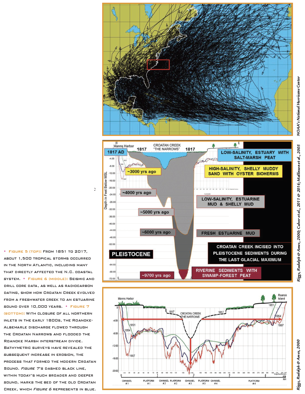
However, frequent coastal storms superimposed upon rising sea level contain the energy to build, modify, and migrate coastal systems. These storms are drivers of change that erode shorelines, move barrier islands, and cause ecosystems to evolve. For many millennia, before the first English explorers landed on Roanoke Island in 1584, extra-tropical storms, tropical storms, and hurricanes played substantial roles in changing and rearranging the natural coastal system. About 1,500 tropical storms have occurred in the North Atlantic in the last 160 years alone, with many impacting the North Carolina coastal system (Figure 5).
During the late 1960s and early 1970s, my colleagues and I began studying the dynamics and evolutionary history of the Albemarle Croatan-Pamlico region.5 This initial research project was largely funded by the newly founded North Carolina Sea Grant Program in 1970 through 1974. The project involved running subsurface surveys, drilling deep core holes, and analyzing age-dated sediments. We developed a summary of the physical dynamics operating within this coastal system and a preliminary map documenting the evolutionary history of Croatan Sound.⁶,⁷ Subsequent research established the details of how Croatan Sound evolved from a drowning creek, surrounded by vast coastal marshes, to a relatively wide and deep estuary 200 years after closure of the northern Outer Banks inlets — dynamic change that had significant human consequences.8,9
Additional research by numerous scientists over the next 45 years has further documented the formation of the entire North Carolina coastal system — including the inner continental shelf, barrier island-estuarine system, and associated riverine and adjacent Coastal Plain uplands.5
The origin and evolution of Croatan Sound (Figures 6 and 7), for instance, clearly demonstrate the details of sea level rise and resulting change in coastal ecosystems through time. The scientific result provided the first detailed 10,000-year history of sea level rise in North Carolina’s coastal system and supplied initial data for subsequent sea level studies within the scientific community.10,11,12,13,14,15
The Natural and Cultural Response to Sea Level Rise
Although the record of sea level change is scientifically well known, this phenomenon is not well understood by the public. Nonetheless, sea level change has left a major record of its overwhelming impact upon the history of coastal cultures, especially in northeastern North Carolina. (See “A Timeline of Natural Changes and Human Responses to Sea Level Rise, 1706-1867” below.)
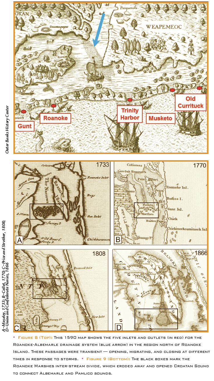
From 1584 to 1587, Sir Walter Raleigh and his English settlers sailed into the salty estuarine waters of Currituck, Roanoke, and Albemarle sounds looking for the “New World.” There were at least five ephemeral inlets through the Outer Banks barrier islands north of Roanoke Island at the time, as indicated on a 1590 map by John White and Theodor de Bry (Figure 8). These fickle openings through the barrier islands were inlets for the settlers and outlets for the Roanoke-Albemarle drainage discharge and the shipping industry.
The English ships probably came through the “Roanoke Inlet,” which at that time was located just south of Jockey’s Ridge in Nags Head and followed a deep channel to the northwest, passing adjacent to the high bluffs and overlying dune field along the north shore of Roanoke Island. The Roanoke Island shoreline then extended well over one-half mile farther north than today’s shoreline, which is still severely eroding.4
During the first three centuries of European settlement, the riverine and estuarine waterways were highways and inlets through the barrier islands crucial for shipping between the newfound colonies and the old world. Early maps demonstrate the dynamic changes that were taking place to the waterways during this time period. The ephemeral inlets through the highly mobile barrier islands routinely opened, migrated, and closed in response to individual storm events.16,17,18,19
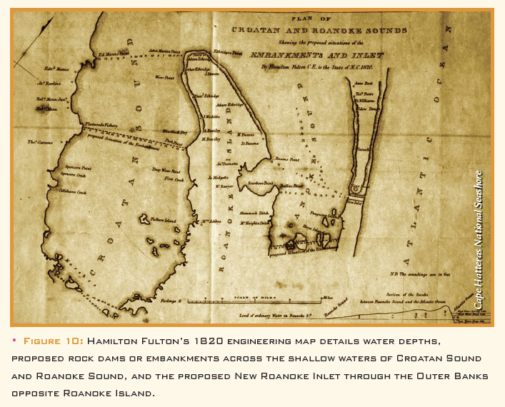
When the colonists were exploring coastal North Carolina in the late 16th century, sea level was at least 3 feet lower than today but rising (Figure 4). The Pamlico and Albemarle Sounds were saltwater estuaries, and the two sounds were barely connected to each other by only a few tidal channels for small boats (Figure 9A).
Croatan Sound, which today connects the two drainage systems, did not yet exist (Figure 11). Rather, it was a drowning Croatan Creek that occupied the “Croatan Narrows,” flowing off the shallow-water marshes on the inter-stream divide known as the “Roanoke Marshes” — which still connected Roanoke Island to the mainland (Figures 9A, 9B, and 9C). The detailed geologic history of the evolution of Croatan Sound is supported by the historic maps and oral traditions of early Wanchese residents, which chronicle how they walked the Roanoke Marshes to the mainland with only a few planks to cross small tidal channels.
As mentioned earlier, the evolution of Croatan Creek into Croatan Sound over 200 years is a direct product of ongoing sea level rise and subsequent flooding across the Roanoke Marshes inter-stream divide that separated the Albemarle and Pamlico drainage basins20,8(Figure 11). In addition to the rising sea level, this drowning process was enhanced by the final closure by 1817 of all five ephemeral inlets that had cut through the Outer Banks north of Roanoke Island (Figure 8). These inlets were the primary discharge points for the Roanoke-Albemarle drainage system into the Atlantic Ocean.
The final closure of these northern inlets forced the full power of the Roanoke-Albemarle discharge, the state’s largest river, through Croatan Creek and Roanoke Marshes into Pamlico Sound and out through southern inlets. In the process, the large flow dramatically eroded Croatan Sound both laterally and downward to produce the wide and deep estuary that exists today (Figures 6 and 7).
Total closure of inlets north of Roanoke Island had other major consequences. Prior to 1817, Albemarle Sound was a brackish-water estuary, much like Pamlico Sound is today. However, no barrier island outlets for the continuous seaward flow of fresh Roanoke River and brackish Albemarle basin waters also meant no inlets for inflowing ocean water. Thus, Albemarle Sound and associated tributary estuaries became freshwater estuaries.
Because salty water is toxic to all land-based trees in the mid-Atlantic climate zone, prior to two centuries ago there were no submerged trees living in the water along the shorelines, not even bald cypress. However, with the rising sea level and the closing of the outlets, the coastal swamp forests slowly drowned — all trees, that is, except the bald cypress. Although this tree must germinate on land, after a certain young age the bald cypress can continue to live, although stressed, under permanently flooded, freshwater conditions.
This evolutionary change put a critical data point on the reality of ongoing sea level rise that is dramatically documented by the hundreds of thousands of bald cypress trees permanently under water and rimming the entire Albemarle estuarine system. Thus, the closing of all inlets north of Roanoke Island by 1817, along with the ongoing upward march of rising sea level, created massive changes in the physical and chemical dynamics of the Albemarle Sound water bodies, causing major shifts in plant and animal life of the associated coastal ecosystems.
This is absolute evidence of coastal change in response to ongoing sea level rise. When Albemarle and Currituck Sounds became freshwater estuaries, the surrounding coastal region experienced the emergence of new bass fishing and wildfowl hunting industries.
Conclusion
Both historical and recent economic development in North Carolina’s coastal system have largely ignored the dynamics of natural change. Centuries of engineering the low swamplands and the more recent introduction of an upland style of business economy — including highways, mega-houses, hotels, and condominiums — on mobile piles of barrier sands has created the potential for a catastrophic failure in response to a large-scale hurricane. Escalating urbanization within this dynamic system almost guarantees massive economic losses in the case of every major storm event.
North Carolina’s coastal economy is largely dependent upon a mixed commerce of agriculture, forestry, and tourism that is perched on a dynamic system of low wetlands and mobile barrier islands. Large portions of these ecosystems are overwhelmed by storms in a period with a rising sea level as the coastal population has boomed in the 21st century. North Carolina finds itself in the throes of a “Perfect Conflict”: an escalating battle between alteration of landscape-waterscape resources and the natural dynamics of coastal change.
North Carolina’s unique coastal system has challenged the engineering prowess of many great minds through the centuries: Thomas Harriot and John White, who mapped northeastern North Carolina for Sir Walter Raleigh in 1585; George Washington, who initially tried to drain the great Dismal Swamp in the latter half of the 18th century; Archibald Murphey’s antebellum efforts to reopen inlets through the Outer Banks; and the U.S. Army Corps of Engineers, who have fought the dynamics of nature from the 19th to the 21st century. With a fuller understanding of the science behind the state’s coastal region, North Carolina’s future challenge is to devise a coastal management and development system that can advance in harmony with the realities of change within this magnificent natural resource system.

A Timeline of Natural Changes and Human Responses to Sea Level Rise, 1705-1867
As the natural dynamics of sea level rise and storms brought evolutionary changes to the coastal system, it severely impacted the course of human settlement in the region. The scientific record of sea level change in coastal North Carolina is underscored by the state legislature’s relentless efforts to prevent coastal change and control the dynamics of water. The historical record of the North Carolina Colonial Assembly and State Legislature document long and unending efforts to tame the wilderness and contain the ongoing processes of natural climate change, such as sea level rise and storm dynamics.
In 1705 to 1706, Bath, located on the Pamlico River estuary with access to the Atlantic Ocean via Ocracoke Inlet, was incorporated as North Carolina’s oldest town.
In 1722, the North Carolina Colonial Assembly established Edenton as North Carolina’s first capital due to availability of shipping through the northern inlets and because of its proximity to Jamestown, Virginia, and Chesapeake Bay.
By the mid-1700s, changing coastal storm activity caused the northern inlets to become increasingly unreliable for shipping, rapidly jeopardizing Edenton’s access to the ocean. The North Carolina Colonial Assembly determined that the more stable Ocracoke Inlet would be established as the major port for northeastern North Carolina.
In 1753, the North Carolina Colonial Assembly established the town of Portsmouth on North Core Banks (southwest side of Ocracoke Inlet) and platted it for development.
In 1766, Governor Tryon moved the capital of colonial North Carolina from Edenton, which was rapidly becoming landlocked, to the new port city of New Bern on the Neuse River with direct access to shipping through Ocracoke Inlet.
In 1784, construction began on the 22-mile Dismal Swamp Canal, built by enslaved Africans to open up shipping from Albemarle Sound to Chesapeake Bay and beyond. This canal was completed for small boats in 1805 and enlarged by the 1820s for larger vessels.
From 1787 to 1789, the Raleigh Company was established by the state legislature to re-open the deteriorating Roanoke Inlet from Roanoke Sound to the Atlantic Ocean.
By 1808 only Roanoke Inlet remained open from Roanoke Sound (Figure 9C).
By 1815, Roanoke Inlet was in its final stages of closing, and Archibald Murphey, a North Carolina politician known as the state’s “Father of Education,” developed a plan to re-establish ocean-going navigation for the Albemarle Sound region.
The ephemeral Roanoke Inlet, the last inlet to allow discharge of the Roanoke-Albemarle drainage basin into the ocean, finally closed by 1817 in the vicinity of Whalebone Junction (Figure 9C). As a result:
- Without any inlets, the Albemarle and Currituck Sounds and their tributary estuaries became freshwater along with major shifts in both the flora and
- Without a direct outlet to the ocean, the freshwater discharge from the Roanoke-Albemarle drainage system was forced to flow through the Croatan Narrows, flooding across the inter-stream divide into the Pamlico Sound drainage system with its outlets to the ocean (Figures 6 and 7).
- The human response was that the coastal system could be engineered and managed to benefit society without regard to the ongoing natural dynamics of a high energy coastal Murphey developed plans for doing so by maintaining a system of canals.
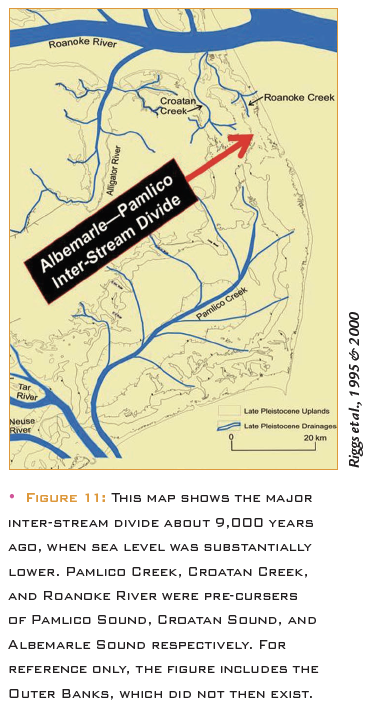
In 1820, English engineer Hamilton Fulton was employed by the legislature to produce a map (Figure 10) and a plan to re-open Roanoke Inlet permanently. His plan required building rock dams across the shallows of both the newly forming Croatan Sound and Roanoke Sound to force the Roanoke River discharge through the proposed Roanoke Inlet with its rock hardened shorelines. Fulton believed the fickle waterways could be engineered.
In 1821, the legislature authorized the Roanoke Inlet Co. to build the dam structures and inlet as laid out on the 1820 Fulton engineering map. The effort failed.
Five more detailed surveys were authorized by the state legislature in 1828-29, 1840, 1843, 1852, and in 1853, all based on Fulton’s 1820 map, but with new depth survey data, slight project modifications, and new dates. All efforts failed.
In 1846, a storm opened the present Oregon Inlet south of Roanoke Island. The ongoing rise of the sea level had flooded over the top of the “Croatan Narrows” and “Roanoke Marshes,” which allowed the Roanoke-Albemarle drainage discharge to flow through Croatan Sound and connect the Albemarle and Pamlico drainage basins. This increased flow rapidly amplified the erosion rates of the Croatan Sound shorelines and its bottom depth (Figures 6 and 7).
In 1857, the U.S. Congress made $50,000 available to dredge a new Roanoke Inlet, but the project ended later that year when the inlet filled faster than it could be dredged.
By the start of the Civil War in 1861, Croatan Sound was already a major body of water with established navigation channels that allowed General Ambrose Burnside to bring 13,000 troops and 67 ships through Roanoke Marshes to carry out the largest naval battle in North Carolina on the north shore of Roanoke Island (Figure 9D).
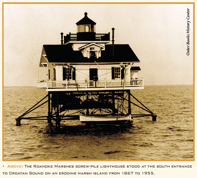
In 1867, Congress built two screw-pile lighthouses at Roanoke Marshes and Colington Shoals, the south-channel and north-channel entrances to Croatan Sound, respectively, as it became a major navigational waterway to the southern Outer Banks inlets (Figure 9D).
The historic freshwater Croatan Creek evolved into a saltwater tidal creek, occupying “The Narrows” on maps from 1590 to 1808 maps (Figures 8 and 9) before becoming today’s relatively wide and deep Croatan Sound, now a major waterway in North Carolina (Figure 2). This 200-year old body of water is a dramatic example of coastal system change in response to persistent storm activity and the ongoing rise of sea level.
This timeline relies on data summarized from the author’s research and teaching career in coastal North Carolina for over a half century.
Notes
1 Riggs, S.R., Ames, D.V., Culver, S.J., and Mallinson, D.J. 2011. The Battle for North Carolina’s Coast: Evolutionary History, Present Crisis, and Vision for the Future. University of North Carolina Press.
2 Riggs, S.R., Ames, D.V., Culver, S.J., Mallinson, D.J., Corbett, D.R., and Walsh, J.P. 2009. “Eye of a Human Hurricane: Pea Island, Oregon Inlet, and Bodie Island, Northern Outer Banks, North Carolina” in Identifying America’s Most Vulnerable Oceanfront Communities: A Geological Perspective, Geological Society of America, Special Paper 460, p. 43-72.
3 Bellis, V., O’Connor, M.P., and Riggs, S.R. 1975. Estuarine Shoreline Erosion in the Albemarle-Pamlico Region of North Carolina. North Carolina Sea Grant Program, Pub. No. UNCSG7529
4 Riggs, S.R. and Ames, D.V. 2003. Drowning of North Carolina: Sea-Level Rise and Estuarine Dynamics. NC Sea Grant Program, Pub. No. UNC-SG-03-04
5 Miller, W. 2019. “New Model of Pleistocene Stratigraphy, Outer Coastal Plain, Northeastern North Carolina: Patterns and Problems,” Southeastern Geology, v. 53, no. 3, p. 181-189.
6 O’Connor, M.P., Riggs, S.R., and Winston, D. 1973. “Recent Estuarine Sediment History of the Roanoke Island Area, North Carolina,” in Environmental Framework of Coastal Plain Estuaries, Geological Society of America Memoir 133, p. 453-464.
7 Riggs, S.R. and O’Connor, M.P. 1974. Relict Sediment Deposits in a Major Transgressive Coastal System. North Carolina Sea Grant Program, Pub. No. UNCSG7404
8 Riggs, S.R., Rudolph, G.L. and Ames, D.V. 2000. Erosional Scour and Geologic Evolution of Croatan Sound, Northeastern North Carolina. N.C. Department of Transportation, No. FHWA/NC/2000-002
9 Riggs, S.R. and Ames, D.V. 2017. “An Uncompromising Environment: North Carolina’s ‘Land of Water’ Coastal System,” in New Voyages to Carolina, University of North Carolina Press, p. 14-40.
10 Culver, S.J., Grand Pre, C.A., Mallinson, D.J., Riggs, S.R., Corbett, D.R., Foley, J., Hale, M., Metger, L., Ricardo, J., Rosenberger, J., Smith, D.G., Smith, C. W., Snyder, S.W., Twamley, D., Farrell, K. and Horton, B.P. 2007. “Late Holocene Barrier Island Collapse: Outer Banks, North Carolina, USA,” The Sedimentary Record, v. 5, p. 4-8
11 Culver, S.J., Farrell, K., Mallinson, D.J., Willard, D., Horton, B., Riggs, S.R., Thieler, R., Wehmiller, J., Parham, P., Snyder, S.W., Hillier, C. 2011. “Micropaleontological Record of Quaternary Paleoenvironments in the Central Albemarle Embayment, North Carolina, USA,” Palaeogeography, Palaeoclimatology, Palaeoecology. v. 305, p. 227-249.
12 Kemp, A.C., Horton, B.P., Donnelly, J.P., Mann, M.E., Vermeer, M., and Rahmstorf, S. 2011. “Climate Related Sea-Level Variations over the Past Two Millennia,” www.pnas.org/cgi/ doi/10.1073/pnas.101561910
13 Kemp, A.C., Kegel, J.J., Culver, S.J., Barber, D.C., Mallinson, D.J., Leorri, E., Bernhardt, C.E., Cahill, N., Riggs, S.R., Woodson, A.L., Mulligan, R.P., and Horton, B.P. 2017. “An Extended Late Holocene Relative Sea-Level History for North Carolina, USA,” Quaternary Science Reviews, v. 160, p. 13-30.
14 Mallinson, D.J., Riggs, S.R., Thieler, E., Culver, S.J., Foster, D., Corbett, D.R., Farrell, K., and Wehmiller, J. J. 2005. “Late Neogene and Quaternary Evolution of the Northern Albemarle Embayment (Mid-Atlantic Continental Margin, U.S.),” Marine Geology, v. 217, p. 97-117.
15 Mallinson, D.J., Culver, S.J., Leorri, E., Mitra, S., Mulligan, R.P., and Riggs, S.R. 2018. “Barrier Island and Estuary Co-Evolution in Response to Holocene Climate and Sea-Level Change: Pamlico Sound and the Outer Banks Barrier Islands, North Carolina, USA,” in Barrier Dynamics and Response to Changing Climate, Springer International Publishing AG, https://org/10.1007/078-3-319-68086-63.
16 Cumming, W.P. 1966. North Carolina in Maps. North Carolina Department of Cultural Resources, Division of Archives and History.
17 Cumming, W.P. 1988. Mapping the North Carolina Coast: Sixteenth-Century Cartography and the Roanoke Voyages. North Carolina Department of Cultural Resources, Division of Archives and History.
18 Everts, C.H., Battlet, J.P., and Gibson, P.N. 1983. Shoreline Movements: Cape Henry, Virginia to Cape Hatteras, North Carolina, 1849-1980.US Army Corps of Engineers Technical Report CERC-83-1.
19 Mallinson, D.J., Smith, C., Culver, S.J., Riggs, S.R., and Ames, D.V. 2010. “Geological Characteristics and Spatial Distribution of Paleo-Inlet Channels Beneath the Outer Banks Barrier Islands, North Carolina, USA,” Estuarine, Coastal and Shelf Science, v. 88, p. 175-189.
20 Riggs, S.R., Cleary, W.J., and Snyder, S.W. 1995. “Influence of Inherited Geologic Framework upon Barrier Beach Morphology and Shoreface Dynamics,” Marine Geology, v. 126, p. 213-234.
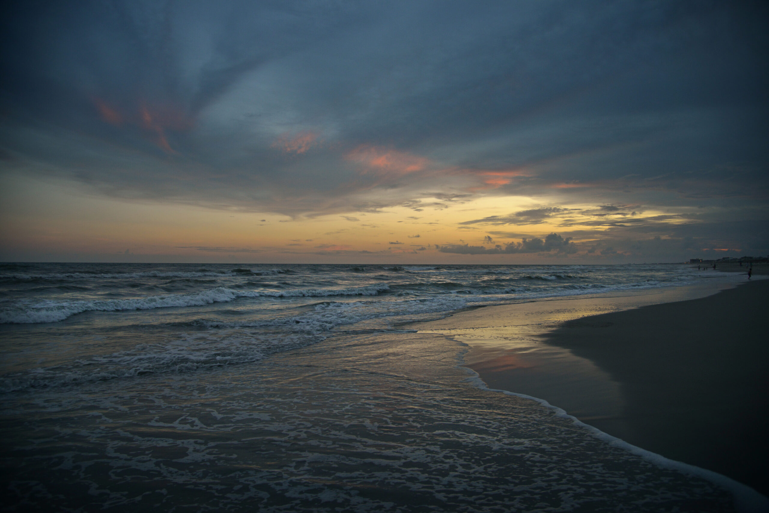
lead photo courtesy of Bill Russ/VisitNC.com
- Categories: