Five Years Later: Lessons Learned From Matthew
Torrential inland flooding from the 2016 hurricane was a wakeup call, sparking state investment in coordinated resilience efforts.
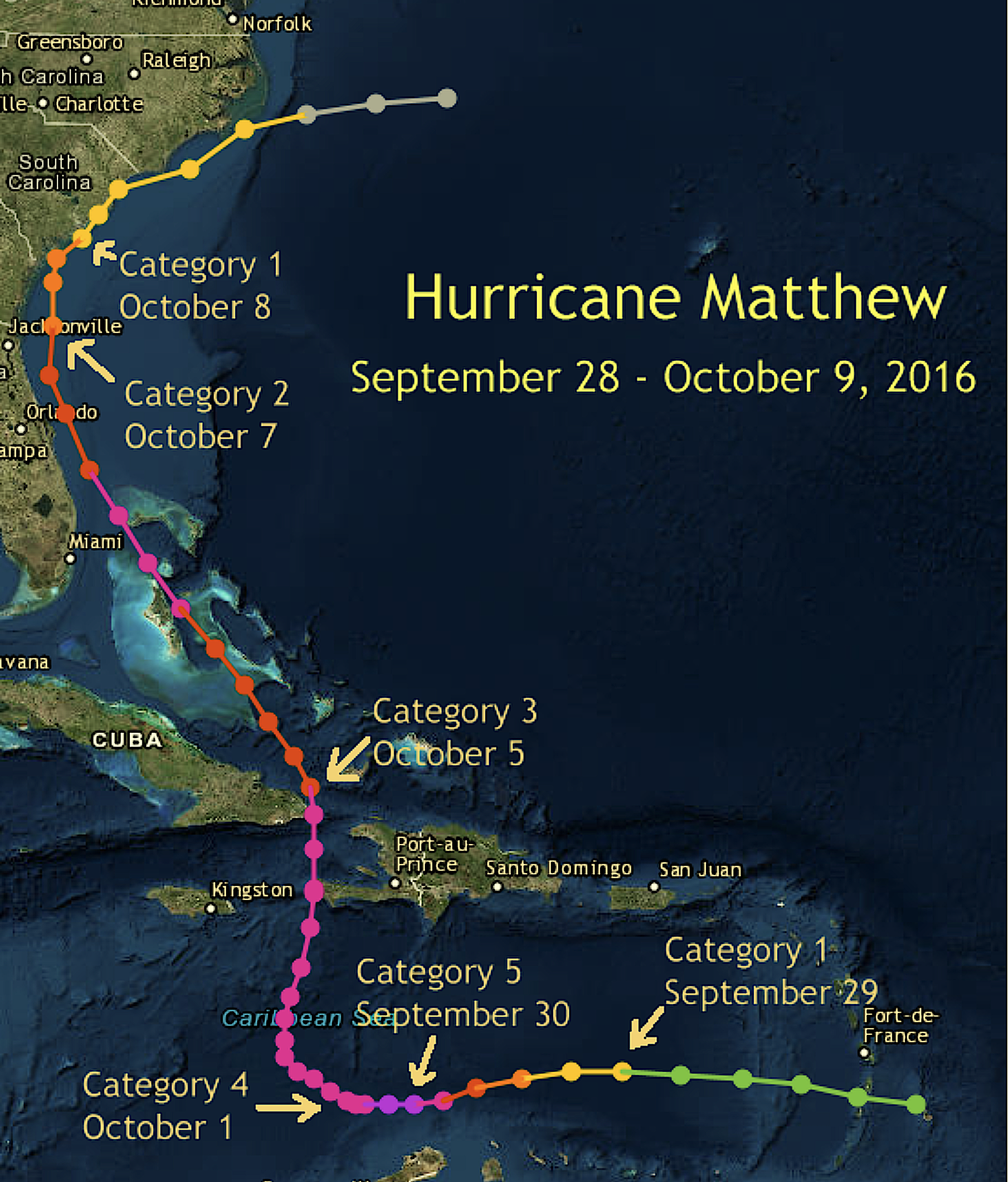
This past October marked the anniversary of one of North Carolina’s most destructive weather events. Five years ago, Hurricane Matthew brushed our coastline but still caused incredible inland impacts, including significant freshwater flooding that broke records set by Hurricane Floyd 17 years earlier.
Matthew was a bellwether. In 2018, Hurricane Florence set new rainfall and flooding records as it inundated communities still recovering from Matthew.
Climate and infrastructure specialists who experienced Matthew and its impacts first-hand have been reflecting on the past half-decade. The lessons learned from that storm have kick-started initiatives to improve resilience in eastern North Carolina.
HURRICANE TRACK AND INTENSITY DON’T TELL THE FULL STORY
As Matthew churned northward across the Bahamas at Category-4 strength, some model forecasts showed the storm looping out to sea before doubling back toward the Southeast coastline.
Ultimately it avoided such an unusual path. But its actual track and evolution still complicated the National Weather Service’s messaging efforts. As storm behavior changed, expected precipitation totals for eastern North Carolina shifted.
“We convey that uncertainty in our briefings to emergency management and the media, but getting the message about the uncertainty to the public is a challenge,” says Rick Neuherz, service hydrologist at NWS Wilmington.
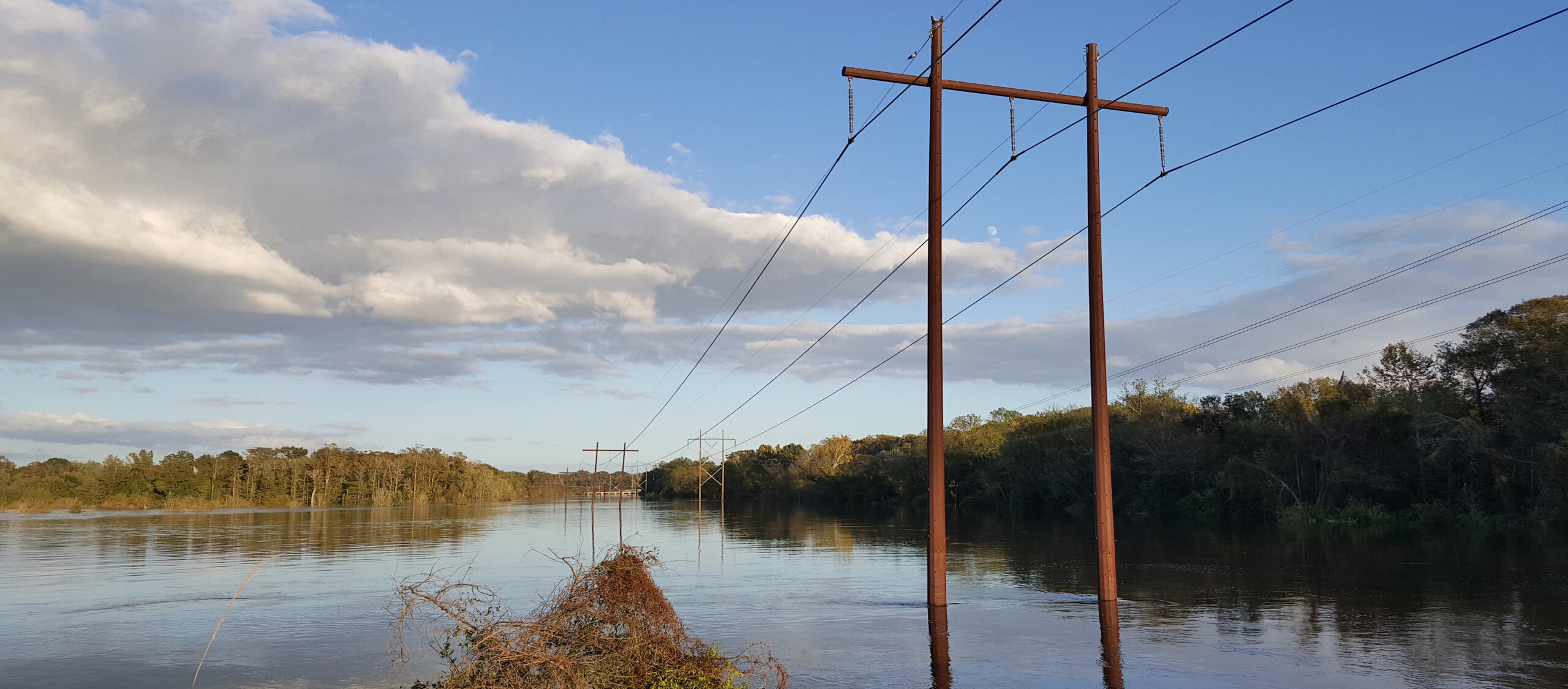
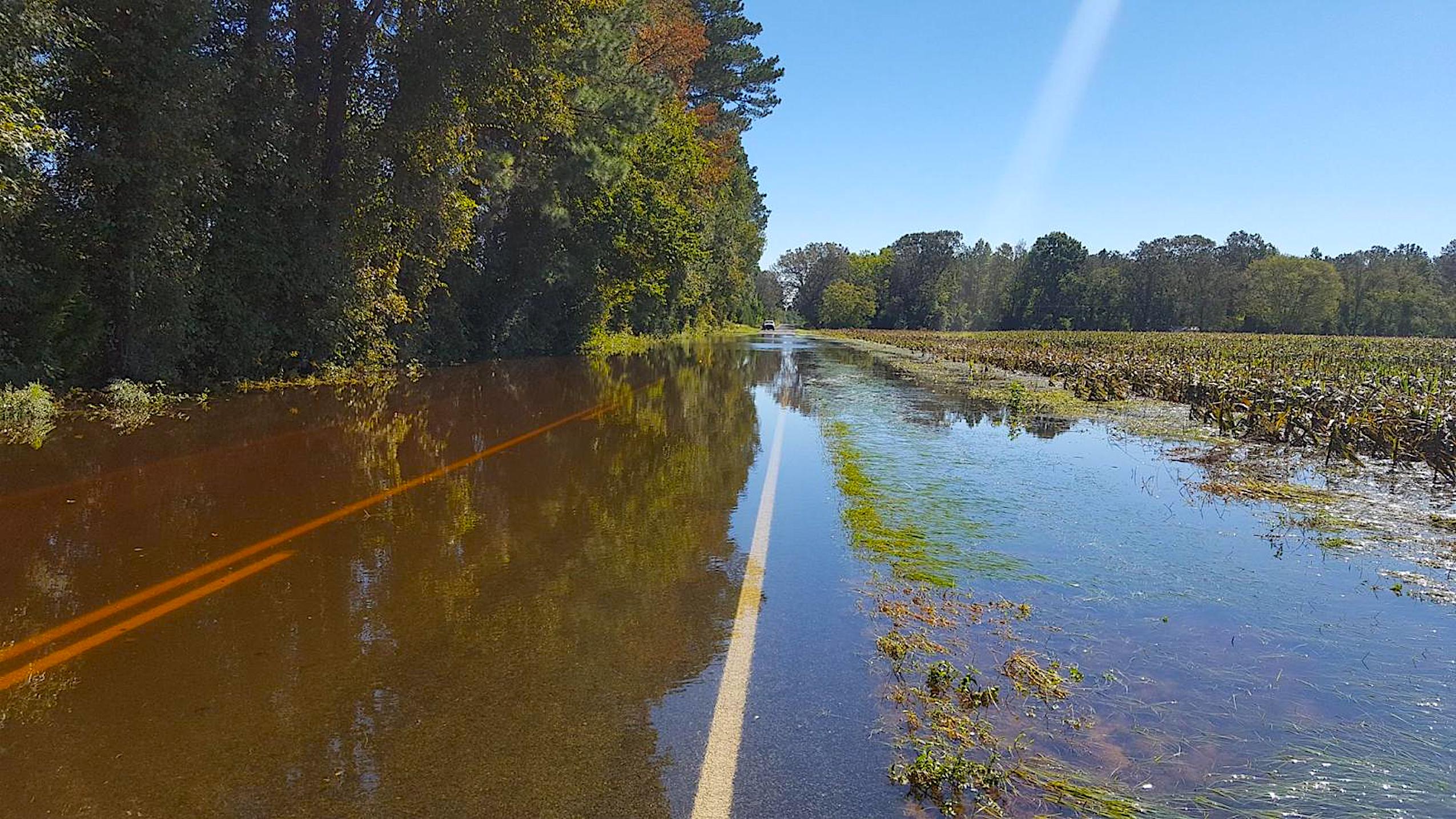
Despite weakening to a Category 1 and remaining mostly off the North Carolina coast, Matthew dumped a foot of rain in areas up to 100 miles inland.
“Matthew was a great example of why we have to constantly reiterate in our messaging to not focus on the skinny black line on the forecast map and understand that the forecast cone is not an impact cone,” says Steve Pfaff, warning coordination meteorologist at NWS Wilmington.
Even after the rain ended, Matthew posed a meteorological threat. A period of strong winds on the back edge of the storm knocked down trees and power lines in the rain-weakened ground, leading to more hazards.
For anyone following the weather radar, those heavy winds would have seemed unlikely as precipitation waned. For that reason, Pfaff says, “we had to issue several messages to advise that the situation was not improving, and in fact winds were going to be worse at the end of the event.”
The lingering storm impacts — far from Matthew’s center, and hours after the rain had stopped — revealed the importance of communicating potential hurricane havoc.

INLAND AND URBAN FLOODING DEMANDS MORE ATTENTION
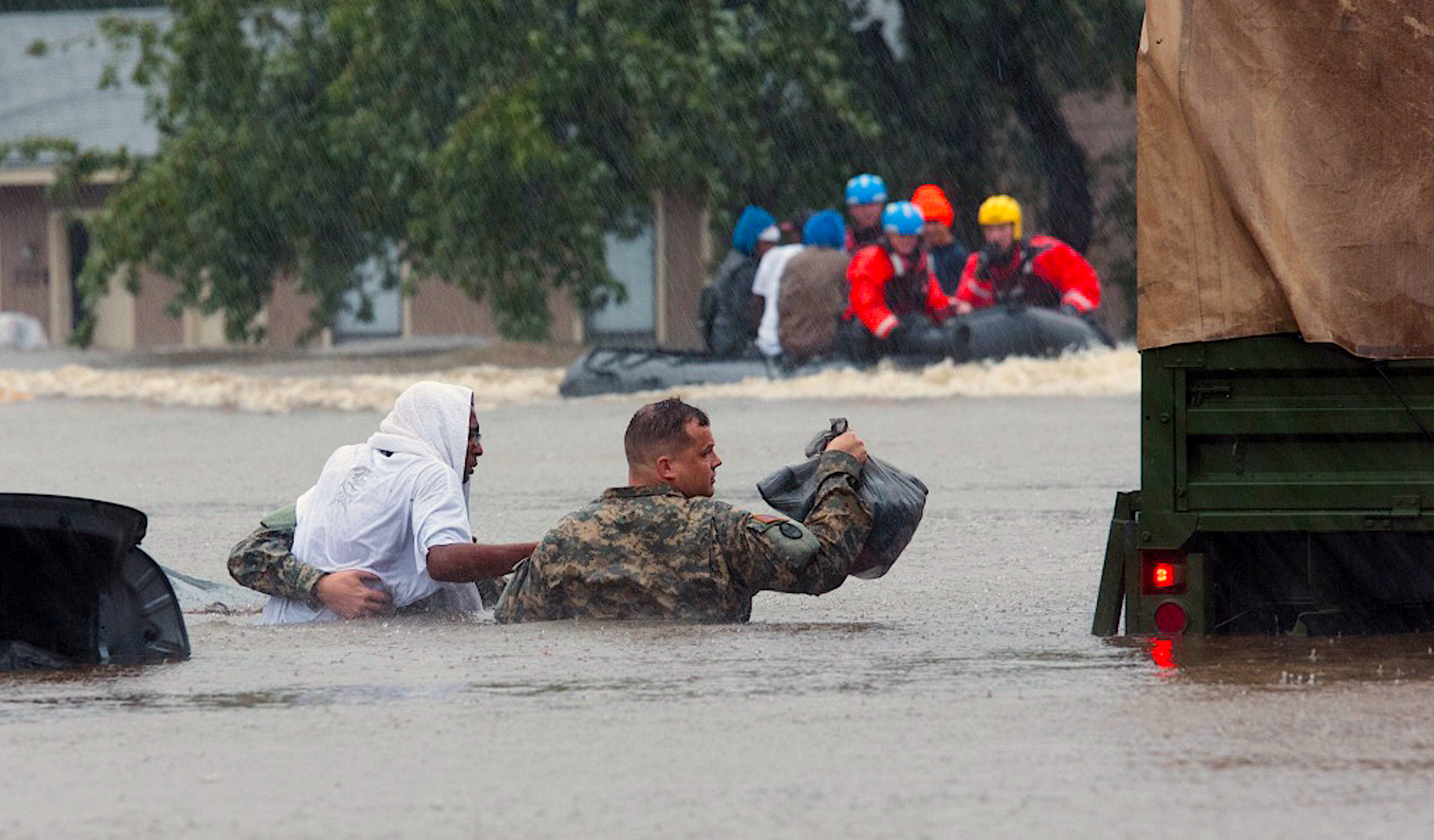
On September 29, 2016, as Matthew had just reached hurricane strength 1,500 miles to our south, a long-lived thunderstorm dropped up to 10.5 inches of rain over Cumberland County. That deluge caused the Cape Fear River and its branches to surge, with excess water breaching the river banks and cascading into downtown Fayetteville, Fort Bragg, and surrounding communities.
During Matthew’s rendezvous with North Carolina, it dropped an additional 14 inches of rain on the same areas, sending the Cape Fear rising once again. During an 11-day stretch, the Little River at Manchester twice eclipsed its long-standing high-water mark from 1945.
At least 17 dam failures were reported in North Carolina after Matthew, according to the News & Observer, and 13 of those were in the Cape Fear basin after those back-to-back heavy rain events.
Meteorologists at NWS Raleigh, who issued forecasts and warnings for some of the hardest-hit areas along the Cape Fear and Neuse rivers, weren’t surprised by Matthew’s inland and urban flooding impacts. However, late changes in the forecasts, combined with a lack of historical flood events in those areas, still caught some people off guard.
“The news and the public focuses so much on the dunes and the surf zone, but in this case, so much of the damage and death happened inland,” says Jonathan Blaes, meteorologist-in-charge at NWS Raleigh. By contrast, “there were no flooding fatalities in a county in North Carolina that touches saltwater,” he says.
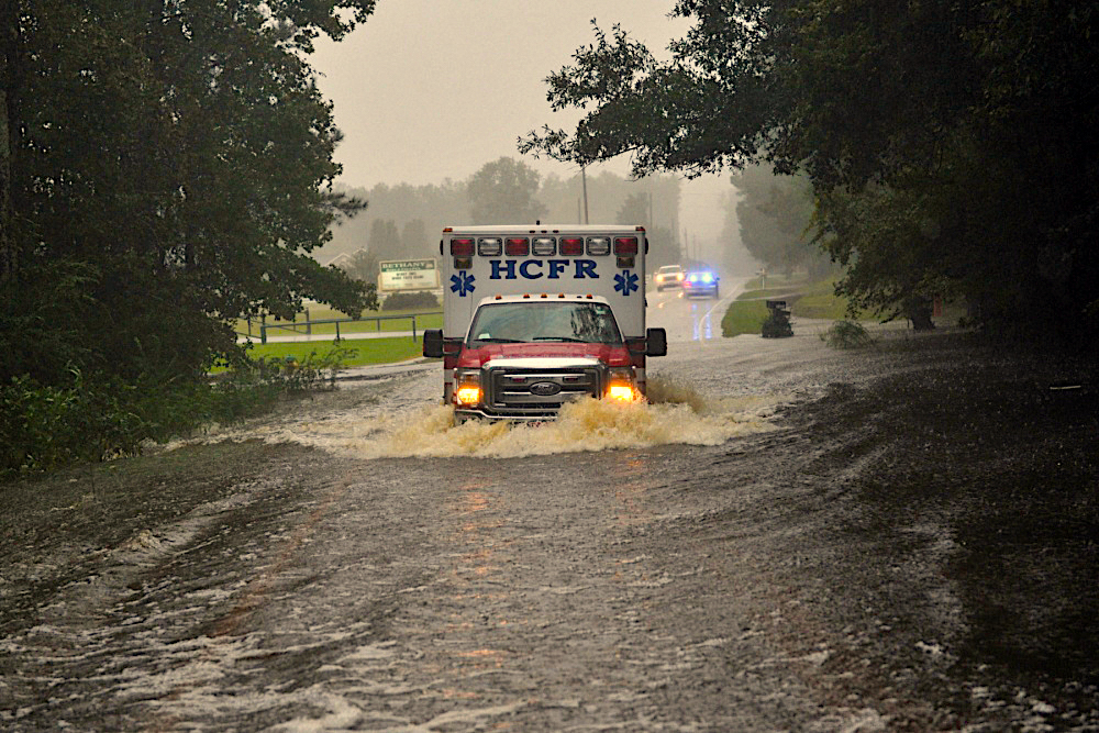
Of the 29 deaths attributed to the storm in North Carolina, 24 were due to drowning, all in fresh water. Those fast-rising and deadly inland flood waters in some ways changed how the NWS responds to, and crafts messages about, hurricanes and their impacts.
“Matthew was one of the steps in realizing things we needed to do” from a service perspective, says Barrett Smith, senior service hydrologist at NWS Raleigh.
For example, Matthew motivated local NWS offices to start sending meteorologists to inland areas such as Cumberland County, where they provide on-site expertise and updated forecast information to local officials. The idea is to help those communities prepare for potential threats like dam failures.
Greater coordination between the NWS, local municipalities, and partners — including N.C. Emergency Management, the U.S. Army Corps of Engineers, and others — was tested during Florence in 2018.
“Groups huddled to discuss hot-spot locations that would experience flooding, areas that may require evacuation, and [positioning of] resources in anticipation of major impacts that would affect life and property,” says Diana Thomas, a meteorologist and planner with N.C. Emergency Management.
On a larger scale, after Matthew, the National Hurricane Center changed how it crafts messages about hurricane impacts on its website. “It used to focus mostly on the wind field and the track. Now on those web pages, rainfall is promoted more,” Blaes says.
In addition, the NWS launched the National Water Model, which can predict streamflow levels and velocities using high-resolution forecasts.
The local support that the NWS is now providing, along with enhanced models, is designed to increase awareness of, and preparedness for, the often rapid onset of inland flooding — especially in places that had never experienced such impacts prior to Matthew.
OUR INFRASTRUCTURE WAS DUE FOR AN UPGRADE
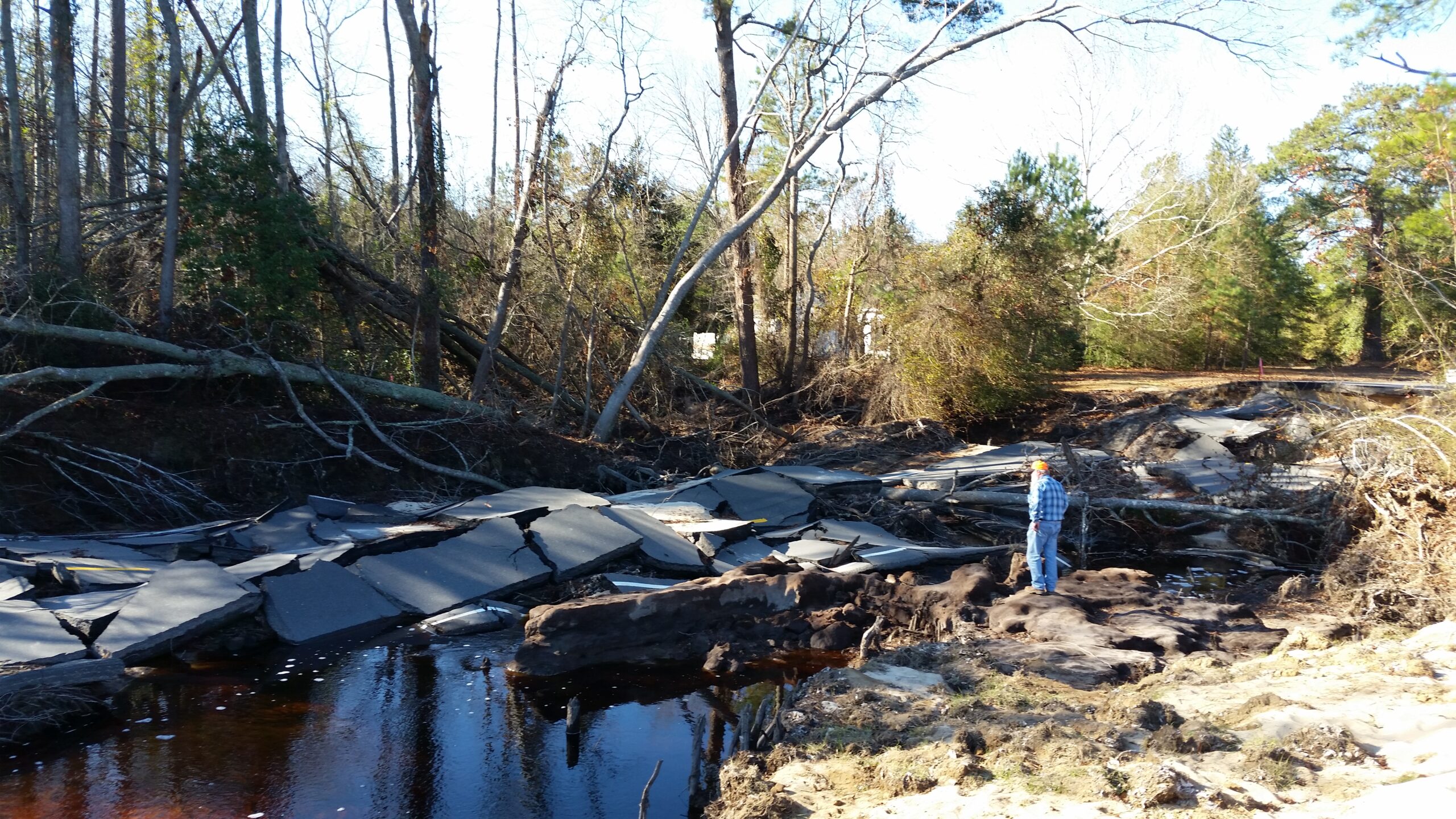
Some of the most unbelievable scenes during Matthew were stretches of major highways and interstates completely under water, effectively turned into new river branches by the overwhelming flood waters. Many local roads also became impassable.
The scale of Matthew’s infrastructure impacts presented a major response and recovery challenge for the North Carolina Department of Transportation (DOT), which manages roadways across the state.
“That single storm had the most pipe washouts of any that DOT has dealt with,” says Stephen Morgan, state hydraulics engineer.
In total, 728 drainage pipes were washed out during Matthew and more than 2,100 roads required repairs, according to a report published by the U.S. Geological Survey.
Rising flood waters in Fayetteville and Lumberton eventually reached the travel lanes of Interstate 95, closing a 60-mile stretch of the road for the weekend after Matthew, with some sections shut down for as many as 10 days.
Flooding on the interstate in Lumberton created a much larger problem in that area. As water spilled over the raised road and through a railway underpass, it inundated the city and created what at the time was the worst flood in Lumberton’s history, Morgan says.
“The same thing happened with Floyd. A lot of places flooded that hadn’t flooded before, especially in vulnerable and less-affluent communities,” he says.
Part of the DOT’s response to Matthew entailed organizational and technological improvements. Those efforts began with better tracking the department’s equipment across the state, including the replacements for those washed-out pipes. “The way we report, collect, and share that information has changed tremendously,” says Andy Jordan, the state hydraulics opera-tions engineer.
“The number of eyes on our current inventory has improved since Matthew. We know what we have on the ground, and we know what we have in our yards.”
The DOT has also partnered with N.C. Emergency Management to identify flood-prone roads using GIS software and to outline mitigation strategies in river basin studies of the Lumber, Neuse, and Tar rivers.
In addition, construction will begin next year on I-95 in Lumberton to reduce the likelihood of significant roadway closures during future storms.
“When those designs are completed and constructed by 2026, we will have raised I-95 high enough to maintain its mobility and connectivity during a storm like Florence,” says Matt Lauffer, assistant state hydraulics engineer.
As Hurricane Matthew reminded us, keeping people and goods moving around the state is crucial to public safety and people’s livelihoods.
FLOODING ON FARMS CAN TURN FEASTS TO FAMINES
Hurricanes can be a blessing and a curse for North Carolina’s agricultural industry. In some areas, rainfall from tropical systems makes up nearly a fifth of the average warm-season precipitation. However, years without sufficient moisture can lead to punishing droughts that destroy crops.
But farming also suffers when a season’s worth of rain falls in less than a week, as happened with Hurricane Matthew. The storm’s October arrival effectively wiped out many crops in eastern North Carolina just before the harvest.
“The biggest impact that I can remember is the loss of whatever crops were in the field,” said Dalton Dockery, the Columbus County extension director for NC Cooperative Extension. “We still had crops like sweet potatoes, soybeans, cotton in the ground, and had just begun harvesting peanuts.”
Summer had already been wet, thanks to soil-saturating rain from tropical storms Hermine and Julia. The additional water from Matthew had few places to go but fields and barns.
“Down east, it’s so flat and low and level that we’re talking a foot to 18 inches of water is all it took to get inundated,” says Richard Goforth, a specialized area poultry agent with N.C. Cooperative Extension.
In total, crop and livestock losses in the state due to Matthew were estimated at $400 million, according to the N.C. Department of Agriculture and Consumer Services. That included 1.8 million chickens killed by the flooding.
Like Floyd, Matthew exposed the vulnerabilities of low-lying farms, and their potential impacts to the surrounding environment. Floyd caused 50 livestock wastewater lagoons to flood; six were breached, according to the Natural Hazards Center at the University of Colorado, sending a surge of sludge into nearby waterways.
In response, the state bought out 42 hog farms and decommissioned 103 lagoons located in floodplains, a move supported by the state’s then Clean Water Management Trust Fund.
That effort helped lessen the damage during Matthew. Case in point: Flooding was limited to six lagoons and two breaches, both on a hog farm in Greene County, according to the N.C. Department of Environmental Quality.
Not all eligible farms receive buyouts. For those that remain, hurricane flooding during harvest time will continue to pose a problem.
MATTHEW WAS A SIGN OF STORMS TO COME
The wait for Matthew’s meteorological successor didn’t take 500 years, 50 years, or even 17 years.
Only two years later, Florence dumped more than twice the rain seen with Matthew and broke the record as the worst flood event in our state’s history. Its estimated $17 billion in damage was more than triple Matthew’s $4.8 billion bill.
That Floyd, Matthew, and Florence caused devastating inland flooding within a 20-year span comes as a shock to some weather forecasters.
“I was confident after Matthew I’d see no more huge floods like that one in my career, but after Florence I no longer have that confidence,” says Neuherz of NWS Wilmington. “The lesson was that even though you just had the big one, it doesn’t mean there isn’t another big one coming soon.”
From rain to river crests to costs, broken record after broken record, and big one after big one, flooding hurricanes in North Carolina are the new normal.
The North Carolina Climate Science Report, which summarizes changes in our climate and their impacts statewide, notes that tropical storms are getting wetter, which is increasing the likelihood of inland flooding.
Lessons learned from Matthew have helped inform the NCDOT’s flood resilience feasibility study for interstates 40 and 95. Its findings are already being implemented into design plans, such as bridges built with extra clearance to withstand a 100-year flood event.
The state is exploring how agriculture can better weather hurricane flooding as well. A sreported by the Coastal Review, the General Assembly approved legislation last year to implement flood control measures such as stream restoration and wetlands enhancement on working lands.
Indeed, a statewide 2017 greenhouse gas emissions study found that farms and forests offset 25% of North Carolina’s current greenhouse gas emissions, or more than twice the average rate of other states.
Matthew also inspired agencies and communities across the state to work together more closely.
“Matthew required a whole community approach to recovery,” says Thomas of N.C. Emergency Management. “The magnitude of the need required federal, state, local, private sector, and nonprofit agencies to develop creative solutions to recovery and communication following large disasters.”
Evidence of those collaborations includes the State Disaster Recovery Task Force, which advises state agencies on recovery and resilience measures related to infrastructure, agriculture, and public health. North Carolina Emergency Management also developed a state hurricane guide pamphlet to provide safety and preparation tips to homeowners, farmers, and business owners.
Five years after Matthew, parts of eastern North Carolina are still recovering financially, structurally, and emotionally. With a greater investment in coordinated resilience measures, hopefully North Carolinians will be more prepared for, and capable of bouncing back, from hurricane disasters.
“To go visit a place after it floods is heart-wrenching,” says Blaes from NWS Raleigh. “The flood water, the mold, the slime, the mud is everywhere. It’s emotional and it lasts so long.”
Links to all sources and more information are available at go.ncsu.edu/lessons, where an earlier version of this article appears on the North Carolina State Climate Office’s “Climate Blog.”
Read More:
- North Carolina Sea Grant’s research and resources on hurricanes and other coastal hazards
- Coastwatch on hurricanes
Corey Davis works for the North Carolina State Climate Office as assistant state climatologist. With state climatologist Kathie Dello, he co-authored “Inside the Greenhouse: North Carolina’s Hottest Year on Record” for the Summer 2020 issue.

Lead photo: In the aftermath of Hurricane Matthew, Greenville, North Carolina, near Pitt–Greenville Airport. Credit: The ed17/CC-SA-4.0 International.