Off the NC Coast
Shipwrecks, Turbidities, and Other Wonders

Take a ride in an imaginary submersible, and explore unique creatures and geological features along the ocean floor.
Seaward of North Carolina’s beautiful beaches lies an ocean floor with complex marine ecosystems, a long geologic history, and telling signs of more recent human influence.
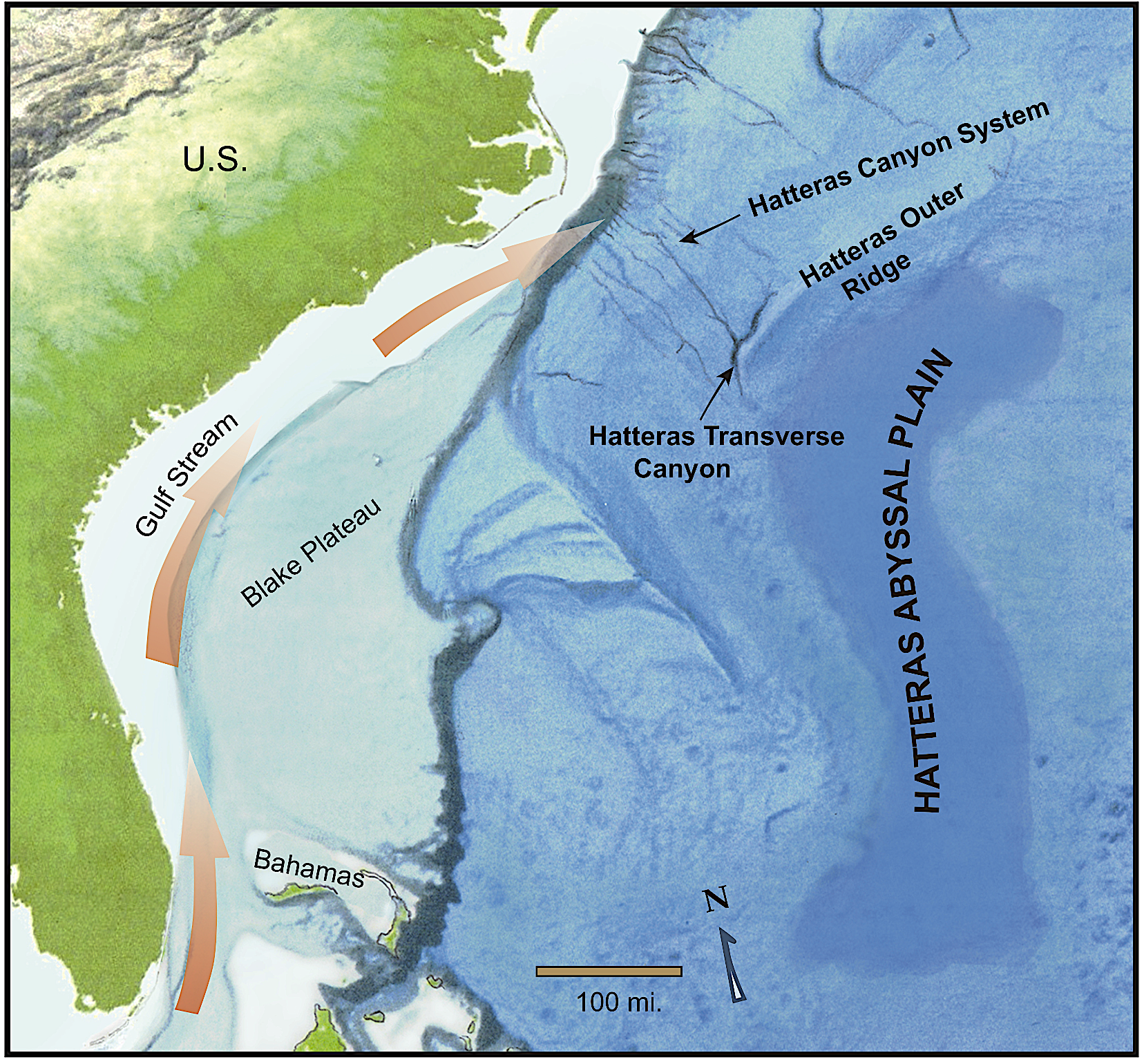
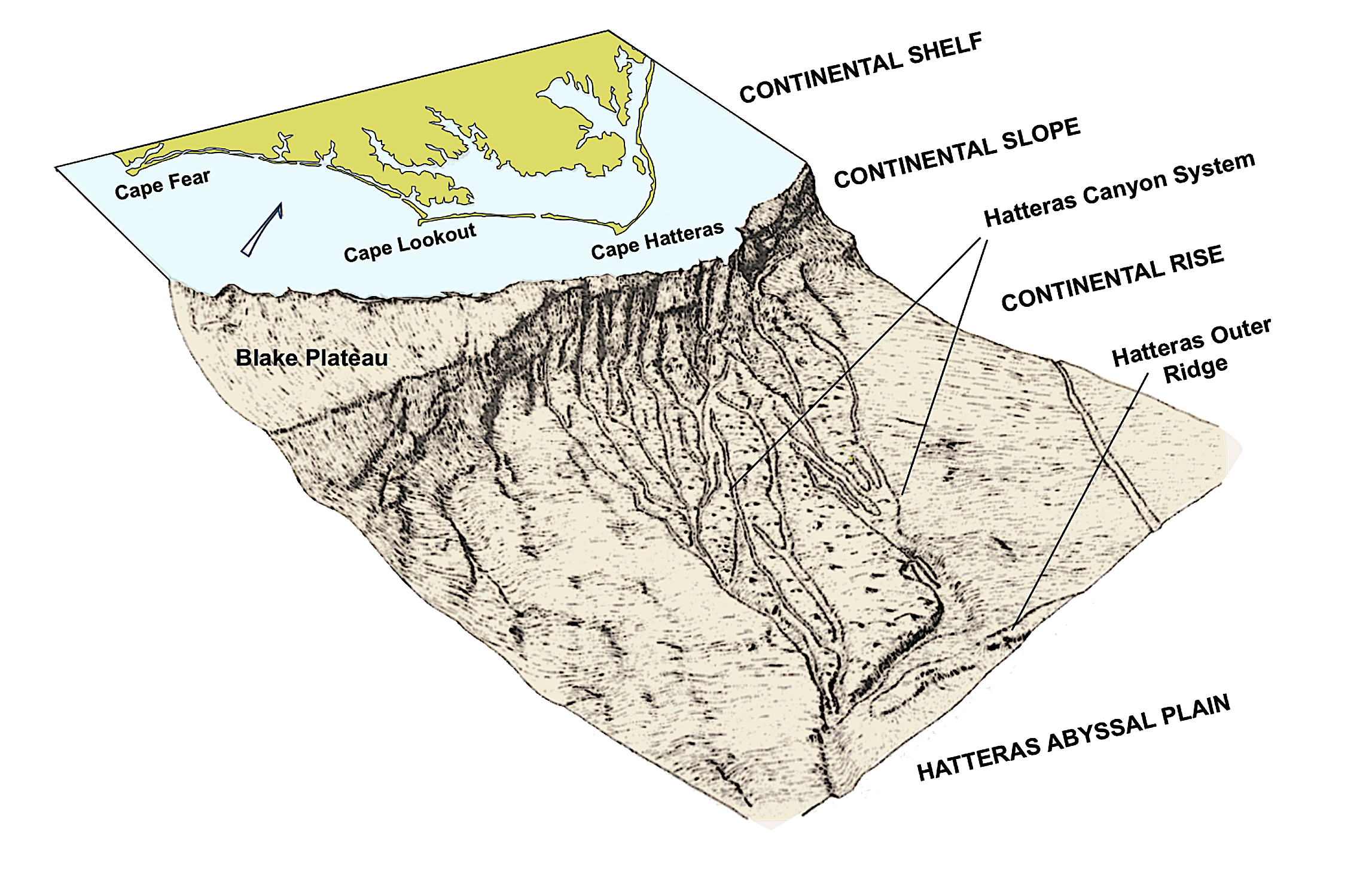
Want to learn more? Imagine yourself aboard a submersible, cruising along the seafloor east from Cape Hatteras. This voyage to the bottom of the sea will take you across four provinces: the continental shelf, the continental slope, the continental rise and, finally, the Hatteras Abyssal Plain. Along the way you’ll encounter shipwrecks, bizarre life forms, largely unexplored marine ecosystems, and strange geologic features found only in the darkest depths of the ocean. Buckle up and get ready for adventure.
The Continental Shelf
Leaving Cape Hatteras, your submersible passes over the continental shelf, a continuation of the coastal plain where it dips under the sea. The shelf’s width varies from 16 miles off Cape Hatteras to about 60 miles at Wilmington.
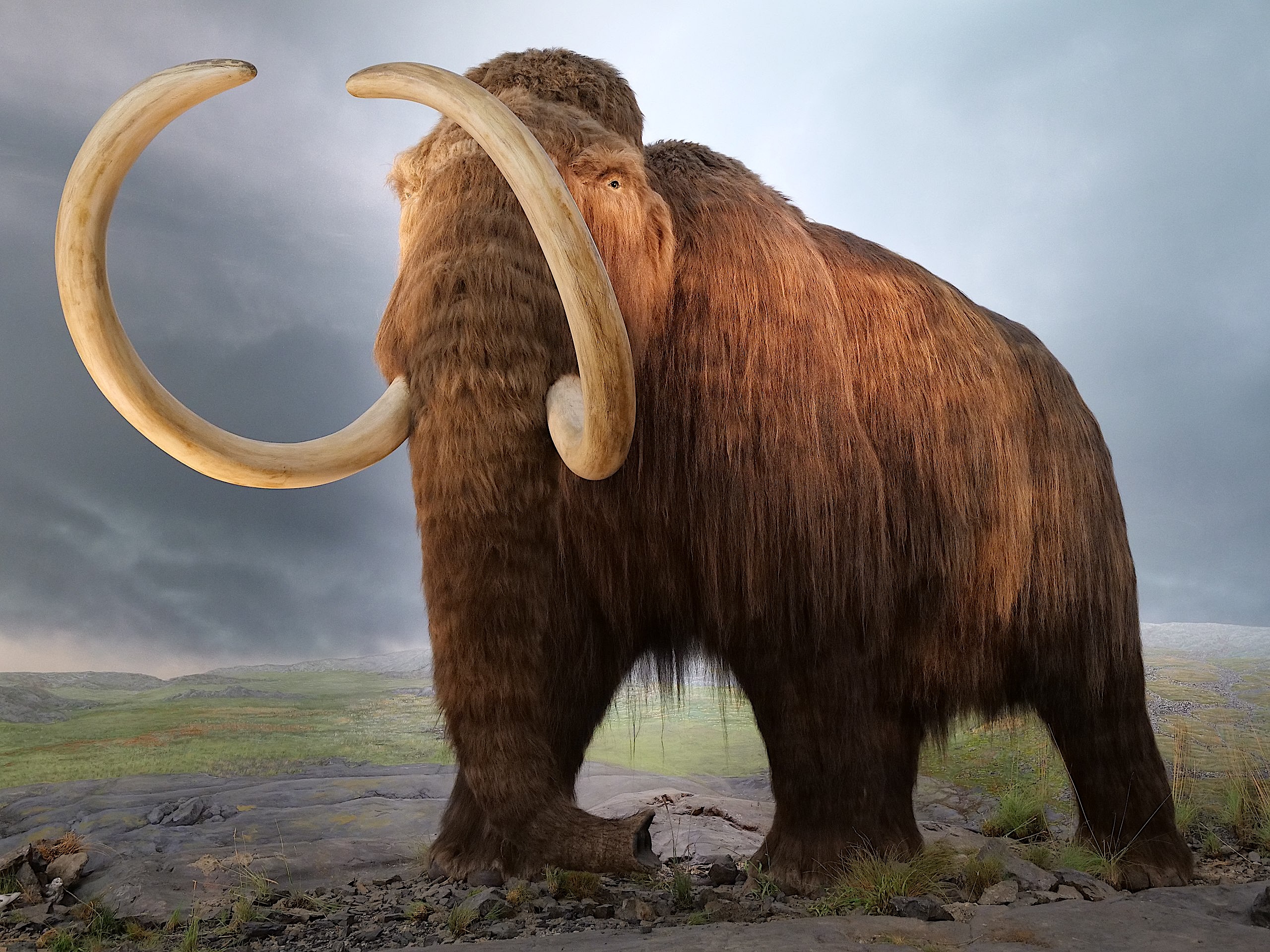
From your submersible, the shelf appears to be a flat tedium of sand broken by an occasional sponge, sea whip, or barnacle-encrusted outcrop. But look closer, and you may discover half-buried in the sand a sunken ship, possibly dating to the 1500s when the Europeans began exploring the Outer Banks. If you’re lucky, you might even spot the curved tusks of a mammoth poking out of the sand.
When North America’s ice sheets began melting around 18,000 years ago, sea level was about 400 feet lower than today. Back then the continental shelf was mostly forest with a smattering of bogs and grasslands, home to saber-toothed cats and dire wolves that hunted the mammoths and other Pleistocene mammals. Sometimes their fossilized bones wash up on our beaches. And now and then, fishers dredge up arrowheads and other artifacts left by people who arrived about this time, following the melting ice north toward Canada.
As the ice melted, sea level rose, engulfing land. Barrier islands formed and migrated west with the retreating shoreline. Sometimes the sea rose too quickly, and the islands were overrun, only to form again farther west as the rate of sea level rise slowed. Peer through the viewing port of your submersible, and you may notice deposits of peat — decomposing organic matter — and black-stained oyster shells scattered across the continental shelf, remnants of ancient salt marshes that once graced the mainland side of these islands.
The sea continued rising until roughly 5,000 years ago, when the North Carolina shoreline stabilized near its present location. Now the sea is rising again, and as the shoreline retreats, the continental shelf grows steadily wider. How far the shoreline moves inland in the coming centuries will depend on how willing and able we are to mitigate climate change.
Near the edge of the continental shelf, at a depth of 115 feet, your submersible passes U-701, a German U-boat that America aircraft sank in 1942. Sunburned and covered in oil, the surviving crew drifted for two days before the U.S. Coast Guard was able to locate and rescue them — testament to the understanding that even during war, sailors on both sides of a conflict regard the sea as a mutual enemy. Once a machinery of violence, U-701 now rests peacefully on the seafloor, reborn as a habitat for marine life and a recreational diving site. (See the lead photo above.)
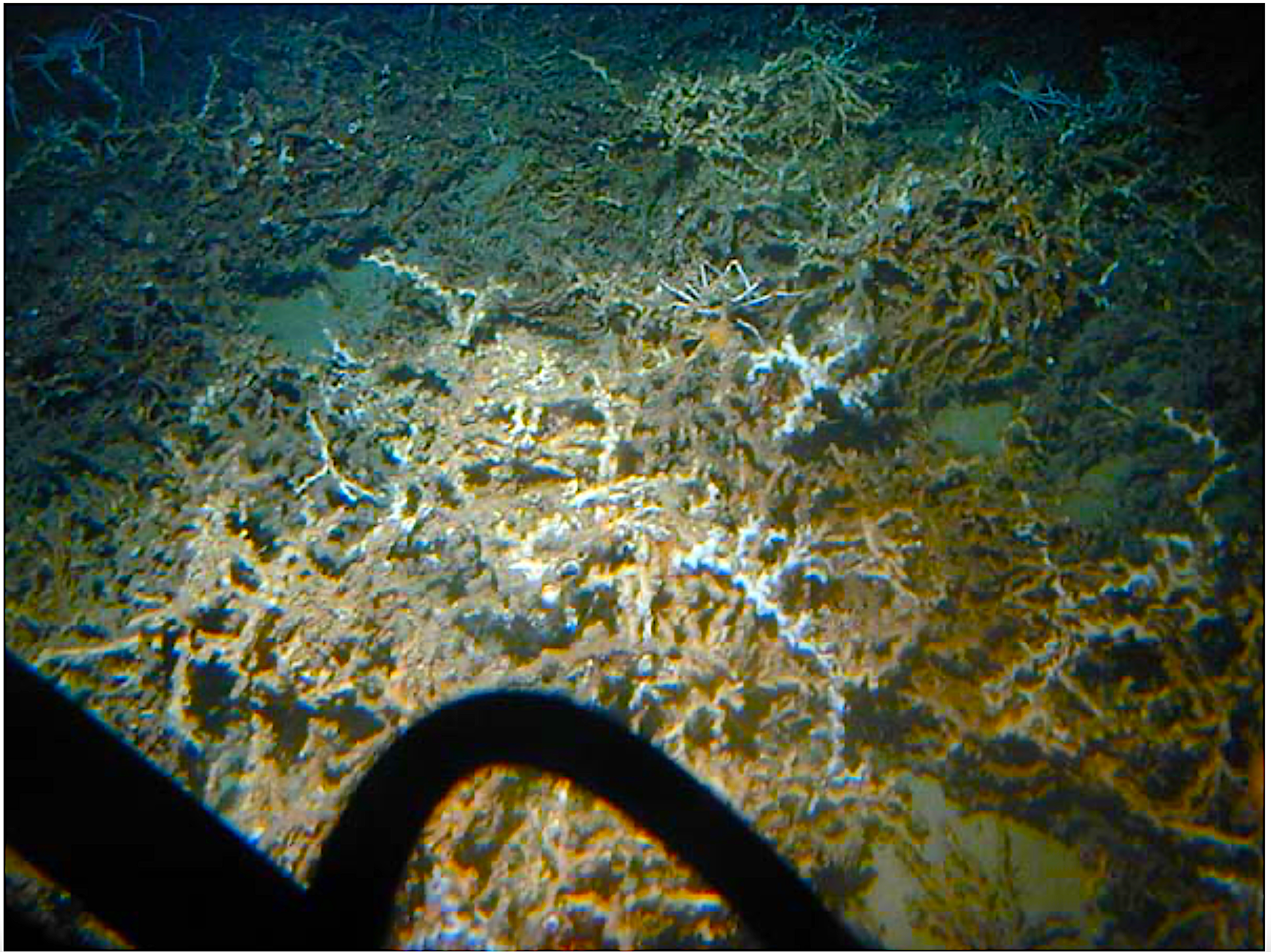
Not far beyond the U-boat lies the Outer Shelf Reefs, the first of North Carolina’s two unique deep-water coral reef systems. As the name suggests, the reefs hug the outer edge of the continental shelf. Press an ear against the hull of your submersible, and you’ll hear the clatter and clicks of a crowded marine ecosystem.
Fishermen ply these reefs for groupers, snappers, and colorful butterfly fish, whose larvae ride the Gulf Stream north from Florida. Scientists are still trying to determine how warming seawater and ocean acidification — byproducts of our carbon dioxide emissions — will stress the corals these fish depend on.
North Carolina’s second coral reef system, the Lophelia Coral Banks — named for a type of coral adapted to cold, sunless waters — lies farther south off Cape Lookout and Cape Fear at depths of 1,000 to 1,500 feet. Neither the Outer Shell Reefs nor the Lophelia Coral Banks have been studied extensively, but scientists believe both are important spawning grounds and food sources for deepand mid-water fish.
Delighting in the colorful abundance of reef life outside your vessel, you may be dismayed to see bits of plastic lodged around the coral. When plastic infiltrates a marine ecosystem, it can entangle animals, expose them to toxic chemicals, or doom species like sea turtles to slow starvation when they mistake plastics for food.
Continental Slope and Continental Rise
As you reach the edge of the continental shelf, you notice the seafloor begins a steep dip into the murky waters below. You are now diving down the continental slope, a feature 8 miles wide and a mile deep east of Cape Hatteras. This is a 12.5% grade and is one of eastern North America’s steepest continental slopes. Plunging down the slope you encounter terrain surprisingly rough and irregular, cracked and sliced by slumps, slides, and submarine canyons up to 600 feet deep, all crisscrossed by innumerable smaller gullies.
In 1969, John Newton, former marine superintendent of the Duke University Marine Laboratory, now part of the Nicholas School of the Environment, was able to make sense of the numerous gullies and recognize them as tributaries of three main canyons. From north to south, these are Keller Canyon (then “Albemarle- Transverse Canyon”), Hatteras Canyon, and Pamlico Canyon. Together, they comprise the Hatteras Submarine Canyon System.
Most submarine canyons along the East Coast are simple systems, formed originally as single channels situated off river mouths when sea level was lower. Some, like the Hudson Canyon off the New Jersey coast, are former river canyons that were drowned by rising seas. The Hatteras Canyon System is different, unrelated to any particular river. As with many of the world’s submarine canyons, turbidity currents — underwater avalanches of dense, fast-moving, sediment-laden water — carved the three canyons that extend down North Carolina’s continental rise.
Turbidity currents — along with earthquakes, tsunamis, and volcanoes — rank among nature’s more fearsome geological processes. Some have been clocked at 60 miles an hour and are capable of breaking telephone cables and even causing tsunamis. As you venture down the continental rise, you might want to keep your submersible a safe distance above the canyon floors… just in case!
In recent years turbidites — sediments deposited by turbidity currents — have enflamed public imagination because they often harbor commercial gold deposits. The most famous is a 500-million-year-old turbidite from southeastern Australia, which, to date, has yielded more than 2,500 tons of gold. Naturally, any gold in the turbidites on the N.C. continental rise would be buried deeply in the sediment. Nevertheless, from your submersible you gaze greedily at the terrain hoping vainly to catch a glint of gold reflected against an endless backdrop of gray.
The transition between continental slope and continental rise is gradual. You might not notice that you’ve entered a new province — until, that is, terrain begins to flatten, and you can no longer determine which direction is upslope. Except for the numerous tributaries of the Hatteras Submarine Canyon System, the 150-mile-wide surface of the continental rise is a smooth, gentle gradient, covered with a mix of muddy sediment and a smaller volume of sand grains.
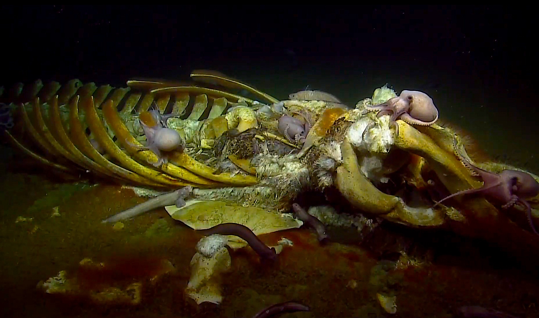
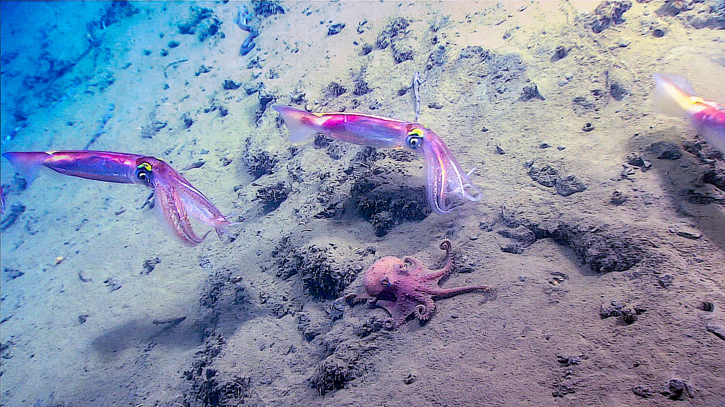
No sunlight penetrates the deep waters of the continental rise, yet life abounds. Using an underwater spotlight, you spy occasional crabs, fish, sponges, squid, and other invertebrates thriving there. Occasionally a whale carcass sinks to the seafloor, providing a cornucopia for a bizarrerie of scavenging hagfish, sleeper sharks, and bone-eating zombie worms. A large whale might sustain this mini-ecosystem for many years. But dead whales dropping like manna from heaven are rare treats. Instead, a steady shower of microscopic organic matter, raining down from the waters above, nourishes most deep-ocean life.
Hatteras Abyssal Plain
At a depth of 17,000 feet, the continental rise merges with the Hatteras Abyssal Plain. Abyssal plains are widespread, topographic features more common in the Atlantic basin than the Pacific. These “lakes of sediment” are the flattest areas on the surface of the earth and formed by turbidity currents carrying sediments across the seafloor, sometimes for hundreds of miles.
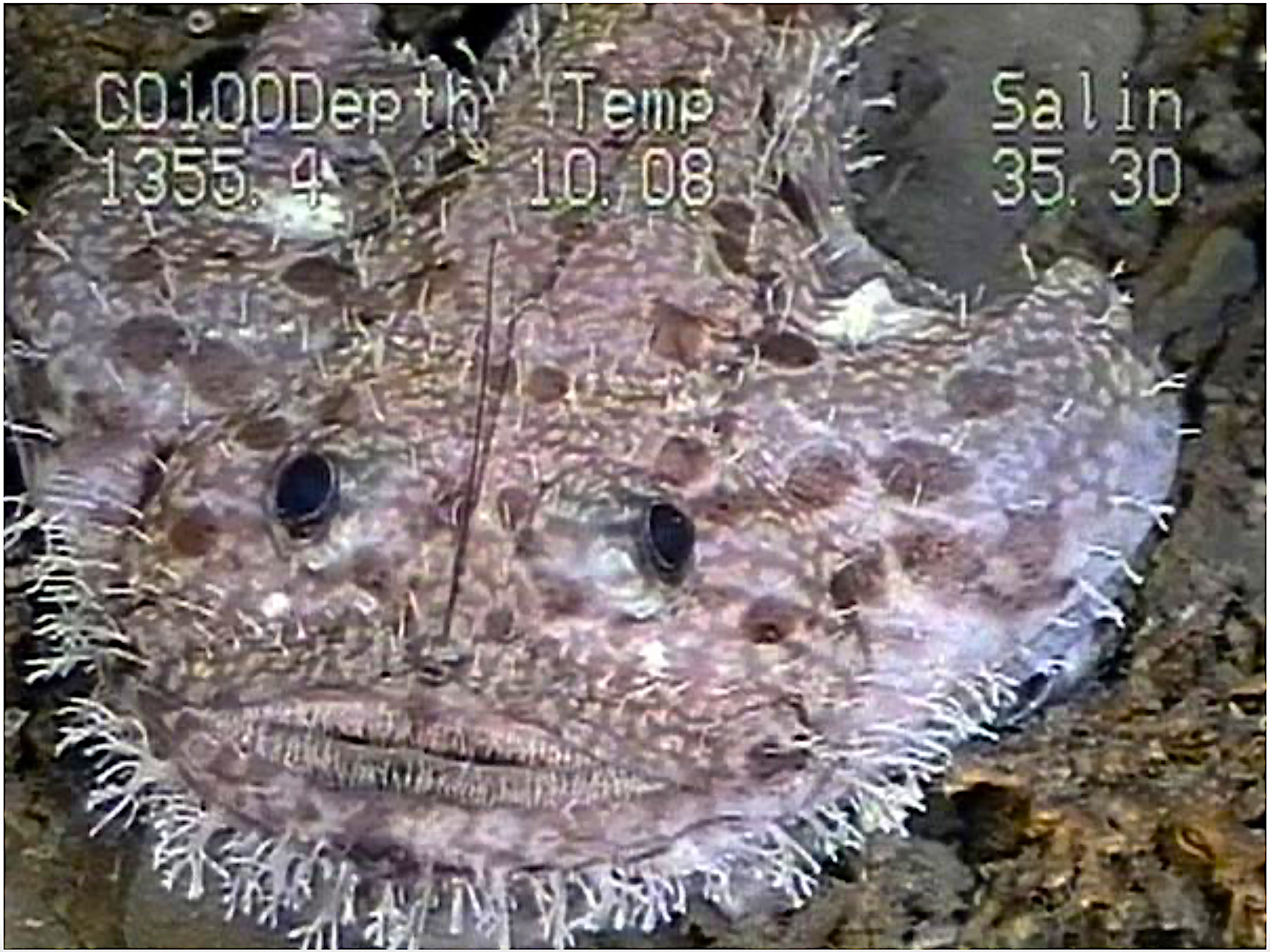
On the abyssal plain, you might catch a glimpse of a rare deep ocean fish or sea cucumber, but the view beyond your submersible’s lights is an unrelenting black, alien monotony, like a troubled vision from one of Dante’s darker dreams. Despite the unimaginable underwater pressure, life here flourishes as a diverse community of microbes, roundworms, and small crustaceans (“copepods”) hidden in the sediment.
Our journey is now complete. As your submersible of the mind turns homeward, take a moment to contemplate the underwater world off North Carolina, the powerful geologic forces that shape its seafloor, the stubborn persistence of marine ecosystems in the most extreme environments and, paradoxically, the vulnerability of those same ecosystems to the ever-widening reach of humanity.
Acknowledgment
The late John Newton, former marine superintendent of the Duke University Marine Lab, conceived the idea of constructing a block diagram of the North Carolina continental margin from data collected on numerous cruises of the Duke University research vessel Eastward. His real genius was in making sense of the many bewildering branches of the Hatteras Canyon System. He also discovered the wreck of the USS Monitor, a Civil War ironclad located in 230 feet of water about 16 miles southeast of Cape Hatteras.
More
The Undersea Vision of Fabien Cousteau: Building the “ISS of the Ocean”
Coastwatch on healthy ecosystems
References
Doyle LJ, Pilkey OH, editors. 1979. Geology of Continental Slopes. Claremore (OK): SEMP Society for Sedimentary Geology.
Menzies RJ, Pilkey OH, Blackwelder BW, Dexter D, et al. 1966. A submerged reef off North Carolina. Internationale Revue der Gesamten Hydrobiologie. 51(3): 393-544.
Newton JG, and Pilkey OH, 1969. Topography of the Continental Margin Off the Carolinas. Southeastern Geology. 10(2): 87-92.
Newton JG, Pilkey OH, Blanton JO. 1971 An Oceanographic Atlas of the Carolina Continental Margin [bathymetric map]. NC Dept of Conservation and Development.
Fritz, SJ, Pilkey OH. 1975. Distinguishing bottom and turbidity current coarse layers on the Continental Rise. Journal of Sedimentary Petrology. 45(1): 57 – 62.
Klasik, JA, Pilkey OH. 1975. Processes of sedimentation on the Atlantic Continental Rise off the Southeastern US. Marine Geology. 19(2): 69 – 89.
Ramsay WRH, Bierlein FP, Arne DC, VandenBerg AHM. 1998. Turbidite-hosted gold deposits of Central Victoria, Australia: their regional setting, mineralising styles, and some genetic constraints. Ore Geology Reviews. 13(1–5): 131-151.
Charles O. Pilkey is a former geologist turned sculptor and author, whose many works include the books Lessons from the Sand: Family-Friendly Science Activities You Can Do on a Carolina Beach and most recently Escaping Nature: How to Survive Global Climate Change. He co-authored both with his father, the late coastal geologist Orrin H. Pilkey, in whose honor Charles wrote this article.
lead photo: NOAA

- Categories: