Climate Resilience: Natural Landscapes and Flood Mitigation in New Bern
Ecosystems, Equity, and a Planning Success Story

1996 marked an abrupt uptick in hurricane activity in coastal North Carolina, when tropical storm Arthur and hurricanes Bertha and Fran made landfall within a few months of each other. These storms caused billions of dollars in damage and significant loss of life. Since then, 38 tropical systems have impacted North Carolina.
Increased storm frequency and a shift in storm characteristics has led some experts to suggest that we are amidst a climate-driven shift. James Kossin, a senior scientist with The Climate Service, described a “global slowdown” over the last 70 years in which hurricanes approach the coast, make landfall, and stall.
These lingering storms release considerable amounts of rain and can result in catastrophic floods. Marine scientists from the University of North Carolina at Chapel Hill identified that these major floods are happening at unprecedented frequencies. For example, in a 22-year period, 3 storms — Hurricanes Floyd (1996), Matthew (2016), and Florence (2018) — produced floods that we would expect to see only once every 50 years.
With events of this magnitude expected to happen more and more frequently, scientists, government officials, planners, and coastal communities are searching for strategies to increase flood resilience.
An Overlooked Component of Resilience Planning
Our student team at UNC-Chapel Hill formed out of a larger interdisciplinary project, “Dynamics of Extreme Events, People, and Places,” which focused on natural, social, and engineered components of resilience in eastern North Carolina. By integrating environmental science, city and regional planning, and computer modelling, our student team is studying how natural and developed landscapes influence resilience to flooding in New Bern.
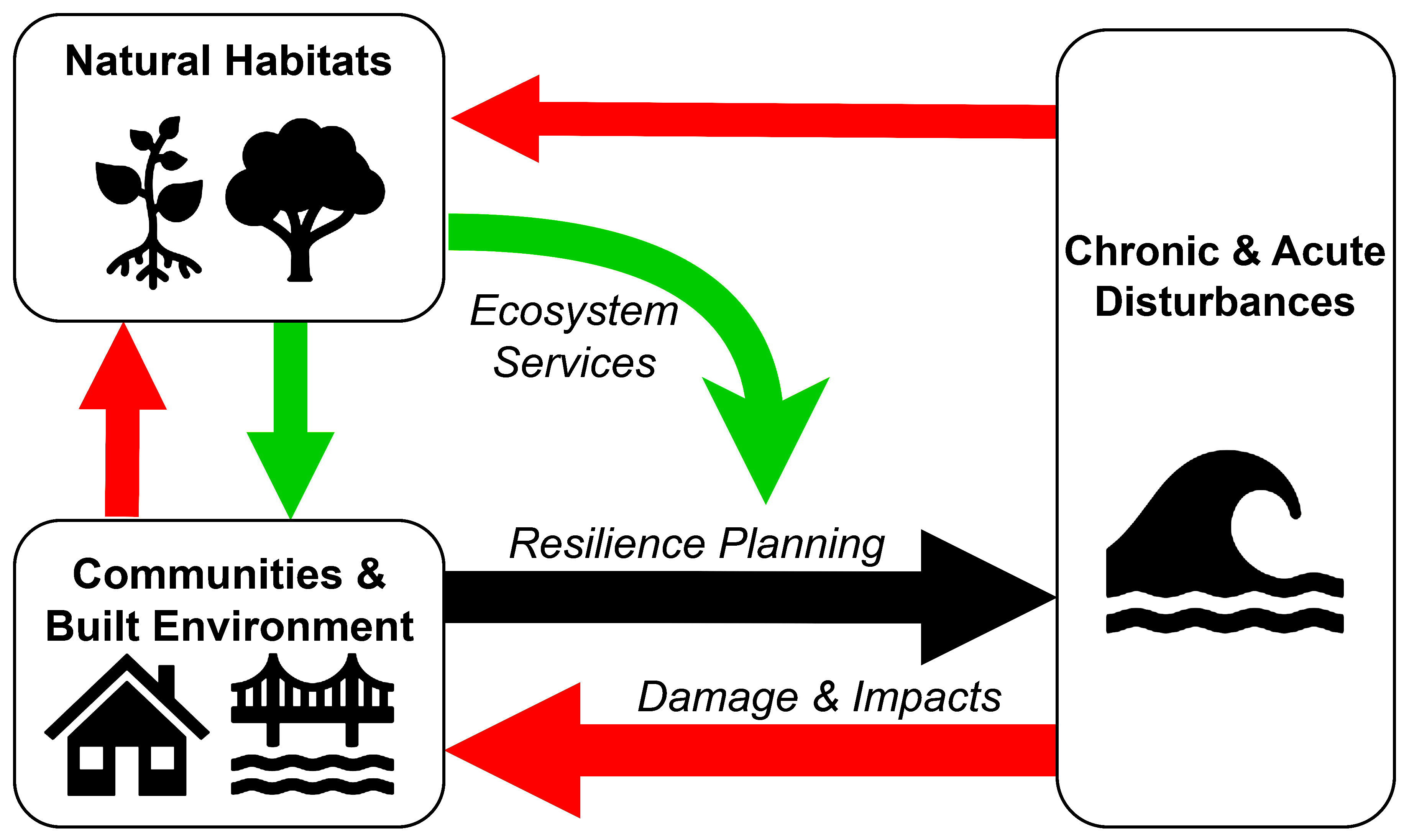
Ecosystems, like swamp forests and marshes, naturally perform numerous functions — or “services” in scientific terms — that support, protect, and generally benefit communities. When hurricanes and major floods occur, these natural systems can stabilize sediments to reduce erosion, store surface water to minimize flooding, and filter pollutants to maintain water quality.
Local land-use decisions largely dictate the size and diversity of habitats, which affects the availability of flood mitigating ecosystem services. Despite the benefits habitats provide, they rarely receive consideration in resilience planning.
In places like New Bern, the landscape is a mosaic of wetlands and developed areas. Inevitably, some people live near ecosystems, and some don’t.
Studies have shown that flood hazards disproportionately affect marginalized communities. Thus, the locations of natural systems relative to neighborhoods has implications for equity in the supply of ecosystem services during storms.
Natural and social systems are intertwined when it comes to resilience to flood hazards. Communities alter the natural landscape, ecosystems influence flood hazards, and flood hazards affect people.
Our team wants to understand how local decision-making influences these processes.
Why Study New Bern?
New Bern’s propensity for flood hazards, as well as its land development patterns and municipal resilience planning efforts, make it an ideal location to explore how multiple variables affect flooding.
Located at the head of the Neuse River Estuary and at the confluence of the Neuse and Trent rivers, New Bern was impacted by significant flooding during Hurricane Florence from coastal storm surge, riverine discharge, and rain. With high magnitude events, like Florence, expected to happen more frequently, it is critical to understand who and what such storms might leave underwater.
The City of New Bern is involved in regional hazard mitigation planning efforts, including the Hurricane Matthew Resilience Redevelopment Plan and the Pamlico Sound Regional Hazard Mitigation Plan. The City also has developed several of their own municipal hazard mitigation and community revitalization plans, several of which focus on the cultural and historical contexts of New Bern neighborhoods. (See “Resilience and Redevelopment in Duffyfield: Revisualizing the Future of an Underserved Neighborhood in New Bern, NC” in the Spring 2023 issue of Coastwatch.)
In the spring of 2022, our student team received North Carolina Sea Grant’s inaugural Coastal Resilience Team Competition award for our proposed project to incorporate ecosystem services into flood resilience planning in New Bern. Our overall objectives are to (1) understand how changes in land cover and flood hazards influence those ecosystems that mitigate flooding; and (2) assess where and for whom local planning policies come together to protect these ecosystems.
We currently are co-developing specific project goals with the City of New Bern so that the data we produce on flood hazards and ecosystems can inform land-use planning and hazard mitigation policies, as well as habitat conservation.
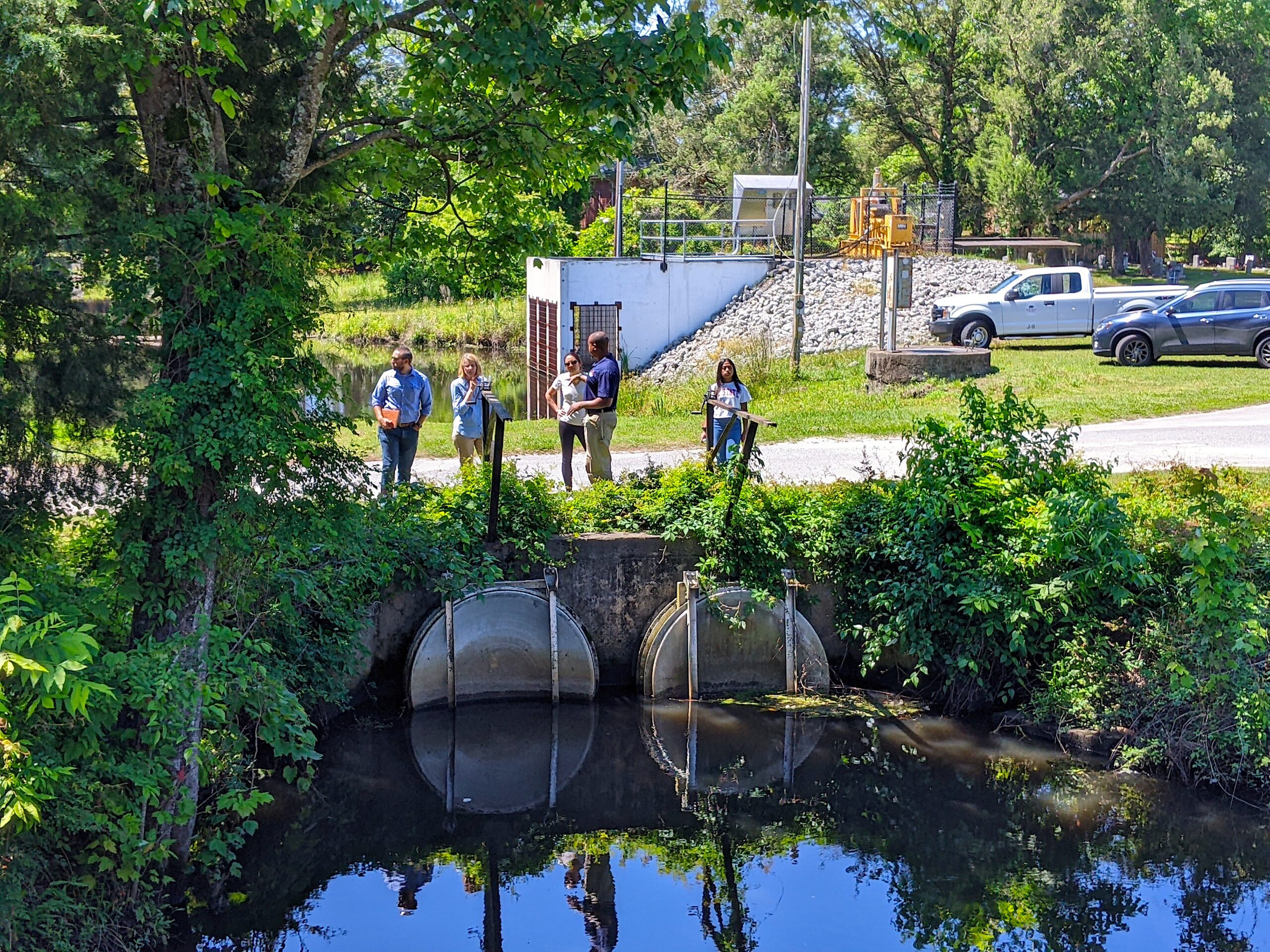
A Planning Success Story: The Jack Smith Creek Stormwater Wetlands
We combined laboratory experiments, computational modeling, and geographic information systems to estimate the supply of flood mitigating ecosystem services in New Bern during Hurricane Florence. Not surprisingly, in highly developed regions, like New Bern’s downtown, habitats are sparse, and the supply of flood-mitigating ecosystem services was relatively low. This contrasts with regions like Jack Smith Creek, where wetlands are abundant, and the supply of ecosystem services was relatively high.
To understand how local plans affect the supply of flood-mitigating ecosystem services, we assessed where and to what extent plans are aligned with — or in conflict with — the prioritization of ecosystems. Generally, New Bern’s planning efforts mirrored our estimates of ecosystem services: low prioritization of ecosystems in the downtown region, which contrasts with the Jack Smith Creek area, where multiple plans work together in an attempt to protect flood-mitigating ecosystem services.
The Jack Smith Creek Stormwater Wetlands project is a concerted habitat restoration effort between The City of New Bern, university researchers, and other organizations. It serves as an example of local plans resulting in a high supply of ecosystem services that mitigate flooding. This restoration project also exemplifies how local plans can promote ecosystems and hazard mitigation specifically in marginalized communities.
Our team digitized a redlining map of New Bern from records in the National Archives and found that a large portion of the Jack Smith Creek watershed drains from neighborhoods described as “poor” or “blighted.” Today, these neighborhoods are home to the highest densities of minority populations and households with low median incomes — and these neighborhoods faced disproportionately high exposure to flood hazards during Hurricane Florence.
We consider the Jack Smith Creek Project to be a success story for integrating flood-mitigating ecosystem services into resilience planning to benefit vulnerable populations and to combat inequitable flood hazard exposure and loss.
Sea Level Rise and the Future of New Bern
Accelerated sea level rise will reshape flood hazards and our experiences with them in the future. Floodplains will likely encroach farther inland, and more chronic “sunny day floods” will become more common.
Habitat loss is a probable result of accelerated sea level rise due to coastal squeeze, a phenomenon whereby habitat migration is blocked by land development, which, in turn, results in the conversion of habitats to open water and the loss of ecosystem services. As flood hazards increase in frequency, it is possible we will simultaneously lose the natural capacity to mitigate flooding.
The City of New Bern already has designated conservation areas in their future land-use plan. However, it will be important to monitor habitat retreat and prioritize restoration in vulnerable regions. It is possible that despite current efforts to conserve natural areas, sea level rise will claim valuable ecosystem services.
Much of our work has focused on catastrophic floods, but we plan to expand our scope to consider the supply of ecosystem
services during smaller scale storms and nuisance floods. Understanding who and what could be underwater in the future can help to develop preemptive flood mitigation strategies.
The student resilience team’s key members on the New Bern project also included graduate students Lauren Grimley and Helena Garcia, as well as undergraduate Jacqueline Ruiz.
For a broad look at North Carolina’s climate resilience planning, see Sarah Spiegler’s “From Portsmouth to Aurora” in this issue.
more
- UNC-CH’s “Dynamics of Extreme Events, People, and Places”
- North Carolina Sea Grant’s Coastal Resilience Team Competition
- “Resilience and Redevelopment in Duffyfield,” Spring 2023 Coastwatch
- Coastwatch on coastal resilience
ANNE MARGARET H. SMILEY is a Ph.D. candidate at the University of North Carolina at Chapel Hill in the Department of Earth, Marine, & Environmental Sciences. Her work focuses on human impacts on coastal habitat distributions and ecosystem functioning.