Weathering the Storm: Five Years After Floyd

“Floyd was a monster,” recalls veteran meteorologist Steve Harned. For the first time in his forecasting career that spanned more than three decades, he was scared. “I knew we were looking at a catastrophic event.”
It’s been five years since Hurricane Floyd flooded the state’s coastal plain with misery, but for Harned and thousands of North Carolinians, memories of the 1999 storm are razor sharp.
“It’s the only weather system in my career that actually frightened me,” says Harned, then meteorologist-in-charge of the National Weather Service Forecast Office (NWS) in Raleigh — the office responsible for weather and river flood forecasting for the state.
Until he retired in July 2004 with 36 years of service in the National Oceanic and Atmospheric Administration (NOAA), Harned worked to improve flood forecasting — and communicating timely, understandable warnings to the public.
In the weeks, days and hours before Hurricane Floyd struck the coast, a network of NWS meteorologists tracked the giant storm along its Atlantic course — from birth as a tropical depression in waters west of Africa on Sept. 2 to maturity as a Category 4 hurricane rolling toward the U.S. mainland by Sept. 13. Weather scientists churned out hundreds of computer models to match the storm’s idiosyncrasies and predict where it might come ashore.
“Millions evacuated coastal areas along Florida, Georgia and South Carolina in anticipation of a totally destructive landfall,” Harned points out. “Its size and its winds were immense.”
Floyd came within 110 miles of Florida’s Cape Canaveral — then shifted its course to take dead aim at North Carolina.
“The day before Floyd made landfall at Cape Fear, dry air circulated to the south side of Floyd, choking down its power from a Category 4 to a Category 2. But, it had a long way to go to wind down, and its tank was full,” Harned continues. “We knew when it hit, something terrible would come of it.”
Before the first band of rain pelted North Carolina, the Raleigh NWS office and the NWS River Forecast Center in Atlanta issued flood warnings. “We were advising county managers and emergency management officials to be proactive and move people out of harm’s way.”
Hundreds evacuated to high ground. Those who chose to ride out the downgraded storm didn’t understand that a Category 2 still is a dangerous storm, Harned says.
At 2:30 am on Sept. 16, Floyd came ashore near Topsail Beach with sustained winds near 100 mph, gusts up to 122 mph, and a 10-foot storm surge. The oceanfront took the first losses in terms of beach erosion, structure damage and dune loss.
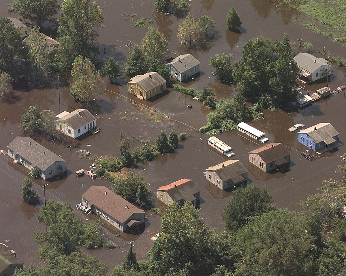
But much of Floyd’s impact was yet to be felt. Rain — torrential rain — inundated low-lying communities across the coastal plain all the way to Interstate 95. Wilmington, alone, measured nearly 20 inches of rain in a 12-hour period.
Extreme amounts of rain continued to fall through the day as the hurricane tracked over North Carolina and Virginia. In less than 24 hours, North Carolinians began reeling from Floyd’s watery blow.
A Centennial Event
“We had forecast a 100-year flood event,” Harned says. “But for some areas of North Carolina, it was a 500-year flood event.”
Floyd could not have come at a worse time for North Carolina, he points out. Earlier in September, Hurricane Dennis — the summer drought breaker — dumped heavy rains from the coast to the Piedmont. Dennis saturated the land, pushed water tables higher all across the state, filled rivers, tributaries and sounds to flood levels — and set the stage for the disastrous visit by Hurricane Floyd.
“When Floyd came ashore, it became a rain machine over the coastal plain. The rivers and sounds already were full, and the water had nowhere to go,” Harned explains.
“When the weather cleared after Floyd, we rented a plane to assess the extent of the storm. As Wilson came into view, it took my breath away. The Tar River, which crested 24 feet above flood stage, was four or five miles wide and moving on a sheet downhill toward Greenville.”
He called the NWS Atlanta River Flood Center, reporting the scene with disbelief. “Get this into a model,” he told colleagues.
“It was daunting to calculate the impact on the people and the environment by such a major weather event,” he says.
There’s frustration in Harned’s voice when he recounts one hard lesson learned from Hurricane Floyd: “We learned that we have excellent, on-target forecasting capabilities, but we had antiquated methods of getting out the message that inland flooding is a serious threat.”
New Forecasting Technologies
Since Floyd, Harned has partnered with several NOAA agencies, the Federal Emergency Management Administration (FEMA), the state of North Carolina and the U.S. Geological Survey (USGS) to develop a more effective means of delivering flood warning information to the public, emergency management leaders and other government officials.
A collaborative demonstration project, under the umbrella of the NWS Advanced Hydrologic Prediction Service initiative, models the Tar River basin. The pilot project combines data from USGS stream gauging stations with the rain estimates to forecast flood potential. The information is shown graphically on an animated river map that can be accessed online at www.csc.noaa.gov/ncflood.
This new approach, which was successfully tested when Hurricane Isabel came ashore in 2003, holds enormous promise for emergency managers, Harned says.
Other new technologies are now in place along North Carolina’s coast to enhance NWS meteorologists’ predictive powers — and ultimately save lives.
Isabel was a successful “test case” for an array of instrumented buoys deployed along the coasts of North and South Carolina. The NOAA-funded Carolinas Coastal Ocean Observing and Prediction System (Caro-COOPS), is part of a national storm prediction system. It enables emergency management officials to make critical evacuation decisions based on information from the buoys’ submerged instruments.
In April, NOAA installed a solar-powered device, known as the Sutron Expert, at the Johnny Mercer Pier at Wrightsville Beach. It is designed to measure tides, wind speed, wind direction, water temperature and barometric pressure to help assess potential for storm surge and coastal flooding. Data is transmitted every six minutes to a satellite that feeds information to NWS and is posted online at www.tidesonline.com.
Making a Comeback
In the days following Hurricane Floyd, H. David Bruton, then N.C. Secretary of Health and Human Services, assessed the disaster this way: “Nothing since the Civil War has been as destructive to families here… The recovery process will be much longer than the water-going-down process.”
Floyd was the deadliest and most costly hurricane in the United States since Agnes in 1972, according to NWS. In North Carolina, 35 deaths, most from drowning, were attributed to Floyd. Damage estimates approached $3 billion.
Most roads east of 1-95 were flooded, bridges washed out, dams failed, water treatment plants swamped, water supplies cut off, and a half million people were without electricity. Farm crops and livestock were wiped out, commercial and recreational fishing idled, and most tourists went home.
Entire towns, including Princeville, disappeared under water. But the human spirit endures, says Samuel Knight, Princeville’s interim town manager and planning and zoning officer.
“On the morning that Floyd came and went, by 5 a.m. water was standing in Town Hall – and rising” Knight recalls. ‘With the dike failing, we knew it was time to evacuate the entire town of 2,200, most of whom are senior citizens.”
By the end of the day, the traffic light at the corner of Mutual and Main was the only visible sign of the town’s presence. “For ten days, all we saw were treetops,” Knight says. “Our people lost everything. More than 750 homes and dozens of businesses were gone.”
The governor’s disaster proclamation freed up federal funds that provided travel trailers for suddenly homeless residents.
The decision whether to accept a federal buy-out program to relocate, or rebuild Princeville in place, was a difficult one. “First, how do you relocate more than 700 households?” he asks rhetorically. “Second, how do you restore a sense of history and pride of place?”
Citizens of Princeville, who take great pride in the fact that theirs was the first town in North Carolina to be incorporated by freed slaves, voted to stay on the land and accept FEMA’s one-time offer. Five years later, Knight says, the dike is rebuilt and most citizens are back home.
“Floyd was a blessing in disguise,” Knight says. “Historic Princeville is no secret any more.”
More than 26,000 volunteers from as far away as the Soviet Union and Korea have helped Princeville emerge from the muddy waters. And, when Prince the Entertainer visited the town to celebrate Princeville Heritage Day last year, he donated $1 million to help with the rebuilding process.
“Our citizens are now comfortable and happy in centrally heated and air-conditioned homes. They are pretty content — except when it rains. Then, I get calls,” Knight says with an understanding smile.
Resilient Resources
The major hurricane activity of the 1990s was a catalyst for unprecedented research targeting the environmental status of the vital Albemarle-Pamlico Estuarine System — the largest lagoonal estuary in the United States. Scientists from universities and state and federal agencies focused on the cumulative effects of a decade of powerful storms, including Hurricane Fran in 1996 and Hurricanes Dennis, Floyd and Irene in 1999.
In 2004, a team of North Carolina State University scientists and collaborators from several North Carolina universities and government agencies reported their findings to the American Academy of Sciences.
“The overall story we see is of estuarine resilience to impacts from these types of major storms,” says JoAnn Burkholder, director of the NC State Center for Applied Aquatic Ecology, and the paper’s lead author.
The study indicates that water quality, numbers and health of most of the area’s shellfish and finfish — and the overall health of the surveyed water systems — appear to be returning to normal.
The storms also may have displaced undesirable organisms, such as the toxic alga Pfiesteria, linked to massive fish kills in the 1990s. The authors theorize that the organisms could have been pushed to areas of the estuary that are less conducive to growth.
While commercial catches of shrimp or bivalve mollusks, such as clams and scallops, apparently haven’t suffered long-term effects from the storms, blue crab numbers remain depressed.
Sea Grant researcher David Eggleston, who co-authored the paper, attributes the decline to the crabs’ interaction with and migration response to the floodwaters — and the overfishing of the mass-migrating crabs. Additionally, Eggleston says, “The floodwaters rushing through inlets may have impeded the crabs’ post-larval migration from the ocean to estuarine nursery habitats.”
Proof in the Catch
N.C. Division of Marine Fisheries (DMF) officials also are interested in learning about the cumulative impact of the 1999 hurricane season on the people who rely on those same waters for their livelihoods.
“A DMF survey is designed to learn how hurricanes impacted peoples’ ability to get back on the water and fish,” explains Brian Cheuvront, manager of the DMF social economics program. “We also want to find out whether assistance programs helped people get back on their feet and back in business.”
Analysis of the survey is not complete, but Cheuvront has observed that a lot of fishers lost gear or had damage to their boats. Some shellfish leaseholders reported that the bottoms were entirely covered over by sediment or destroyed completely. However, some commercial crabbers saw a bounty of landings in the weeks after Floyd as crabs headed to high-salinity waters.
That was not the case for Guy Sawyer, whose family has dropped crab pots into the Pungo River for generations. Hurricane Floyd was a turning point, he says.’ Floyd was in my house and in my folks’ house,” he recalls. “I never have seen anything like it, and I have been on the water all my life.”
Three-foot waves energized the otherwise flat waters of Slades Creek, where Sawyer maintains his boats, dock and gear at the edge of family-owned land. Many of the crab pots he thought to be safely stored were washed away.
“It was weeks before I could get back on the water, and then there was a lot of debris floating around,” he says.
With crab catches down since 2000, Sawyer turned to fishing for flounder and puppy drum to supplement his income.
He has replaced all his lost pots and is optimistic about filling them with abundant catches this season. It’s a way of life he doesn’t plan to swap, in spite of all the uncertainties.
For his part, Bonnie Baynor, a part-time fisher from Washington, doesn’t plan to give up his day job. He is a 39-year veteran of Weyerhaeuser.
When Floyd hit, he and other crabbers along Nannie Smith’s Gut, one of many ditches off Broad Creek, pulled up equipment and didn’t go back on the water until the following spring.
Baynor points to a small, rental house he owns. “It was elevated after Hazel, but Floyd still took the duct work out from under it, along with crab pots I pulled from the water.”
The incoming surge that swamped the small finger of land was bad. But the worst was yet to come. “Floodwaters from Tarboro, Washington, Greenville and all rushed through to get to the Pamlico Sound,” he recalls.
It was an awesome sight and proof that no hurricane should be taken for granted, he says. When the storm warning flags fly, Baynor has this advice for fellow watermen: “Get off the river and put into a safe place.”
Hurricane Floyd Impacts in North Carolina
35 deaths
$3 billion in damages
7,000 homes destroyed
17,000 homes deemed unihabitable
56,000 homes damaged
10,000 people in temporary shelters
1,500 rescues
This article was published in the Autumn 2004 issue of Coastwatch.
For contact information and reprint requests, visit ncseagrant.ncsu.edu/coastwatch/contact/.
- Categories:


