Bridging the Digital Divide
Free Mapping Helps Small NC Towns Meet Water Quality Requirements

“The collaborative and adaptive approach used in this project resulted in a tool that can immediately benefit small water utilities.”
— Kaitlin Tucker, coordinator for research and engagement, NC Water Resources Research Institute
A collaborative research team led by Duke University’s Nicholas Institute for Energy, Environment & Sustainability is working to lessen the digital divide for small rural water utilities and helping them fulfill reporting requirements. With funding from the NC Water Resources Research Institute, the team has developed a free mapping tool called “BoundarySync,” part of the Internet of Water (IoW) project.
Digital boundaries can readily define service areas, showing where water systems feed properties. Having an easily accessible and current boundary map allows utilities to quickly answer simple customer questions like “Are you my service provider?”
Having a digital map of service area boundaries also makes it easier for utilities to perform analyses of information that are often required for state and federal funding applications. Additionally, a digital map can help utilities better understand their constituencies and the water quality of their watersheds by making it much easier to overlay census tracts, water quality data, and other information.
Paper Maps and Lists (or No Lists at All)
Despite the benefits of digitized boundaries, many utilities in North Carolina — particularly small rural utilities — rely on paper maps, images, a list of addresses, or, in some cases, no list at all. The lack of digitized boundaries presents a major barrier for local officials to use water data effectively. It also makes it nearly impossible for the state to conduct regional analyses about water supply and infrastructure.
“Better water data equals better water management,” says Lilli Watson, grant management and communications lead for the project.
And the first step to better water quality is knowing where the water is coming from. So, in 2019, Duke researchers partnered with the North Carolina Department of Environmental Quality to create digital service area boundaries for water systems serving more than 3,000 people.
However, for the newly digitized boundaries to be helpful, they require regular updates and maintenance using mapping software that most small-scale utilities can’t access.
Open-Source Mapping
In 2021, the research team developed BoundarySync, a first-of-its-kind open-source mapping tool designed for utilities to create, update, and maintain digital service area boundaries. They worked closely with the North Carolina Rural Water Association (NCRWA) throughout the process to ensure the tool was easy to use and meets the needs of small water utilities.
As such, it doesn’t require specific technical skills and is available to access online at low cost — and it’s free to members of NC Rural Water Association.
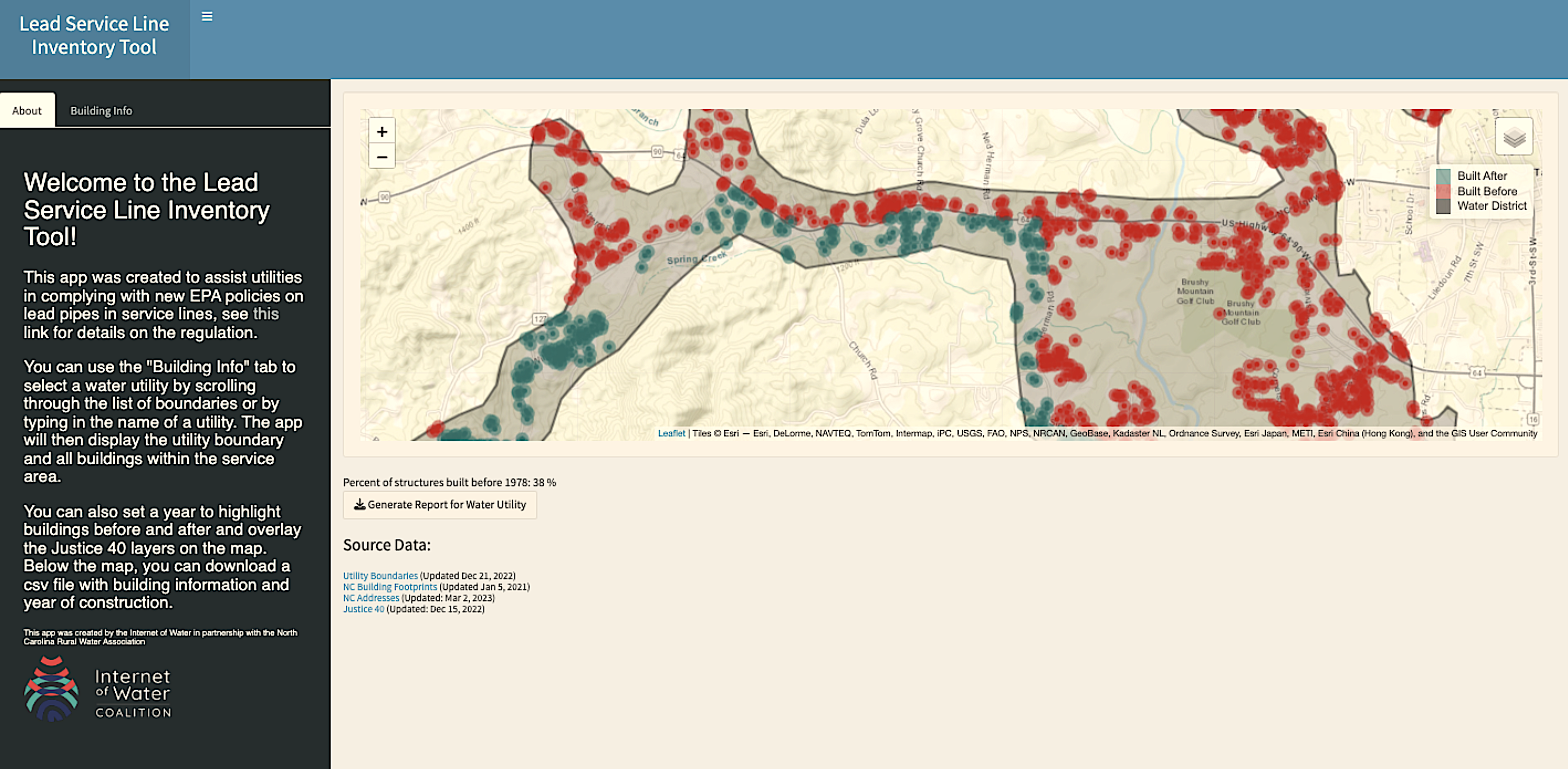
“A total of 532 utilities’ service area boundaries can now be viewed and updated through BoundarySync,” says Ashley Ward, the project’s lead. “And the smallest systems that still lack digital boundaries are now able to create them with this easy-to-use tool.”
The team developed the video above, an overview of BoundarySync, along with two instructional videos that are available on the Internet of Water website.
Lead, Copper, and a Ticking Clock
In December of 2021, the EPA announced new lead and copper rule revisions requiring that all community water systems, regardless of size, develop an inventory identifying potential presence of lead within each service line connection by October 16, 2024.
In response, the research team created a new dashboard, making BoundarySync directly responsive to water systems’ needs.
“This dashboard will reduce the time commitment needed to comply with the new legislation and lower the burden on small rural utilities,” says Watson. “It also includes data identifying disadvantaged communities eligible for financial benefits as part of the Justice40 Initiative,” a federal project that serves communities that are underserved and overburdened by pollution.
The NCRWA is diligently working to spread the word and provide small systems with resources to meet the EPA’s requirements, but the clock is ticking.
“We’re slightly over a year from the deadline, and there’s still systems that are unaware of exactly what’s going to be required of them to meet that deadline,” says Brian Grogan, executive director of the NCRWA. “BoundarySync will be a key resource in this effort.”
Grogan says the mapping tool will help utilities zero in on lines most likely to contain lead. “The way it’s set up now, you can do a search based on the year structures were built to focus your efforts on structures built before the lead ban.”
10,000 Water Systems Nationwide
The digital divide is not just an issue for North Carolina’s utilities.
“At least 10,000 water systems in the country currently have no way of digitizing service area boundaries,” says Kyle Onda, technical lead on the project and director of the Internet of Water Initiative at the Lincoln Institute’s Center for Geospatial Solutions.
Onda is currently working with Oregon and California state agencies to adopt the tool and hopes many more states also will find it useful. Additional potential applications include digitizing wastewater and stormwater boundaries, land conservancy districts, or irrigation district boundaries.
“Because we’ve made the software open source and available on GitHub, anyone can download and adapt BoundarySync to their own needs,” he says.
“Over the course of this project I learned a lot about how small utilities function,” Watson adds. “They’re often run by very small teams who are working really hard and have a lot to handle. BoundarySync is one small technical thing that will be helpful in a few areas, but there’s no single solution to address the challenges that small utilities face.”
New impending legislation limiting the amount of PFAS in water systems is aimed at protecting the public, but it also presents an added challenge for the industry, especially for small, rural systems.
The primary challenge facing small utilities is capacity, says the NCRWA’s Grogan.
“A lot of these systems are a one man show,” he explains. “They wear a lot of hats. It’s not just dealing with water or wastewater. Typically they’re doing both. It’s difficult for them to put everything down and focus on something that can be as complex as dealing with emerging contaminants. That is the challenge.”
The Internet of Water team at Duke created the informational video above, which both highlights the work of the NC Rural Water Association to build technical capacity and emphasizes some of the challenges unique to rural, small utilities.
Grogan says utilities workers feel a responsibility toward their communities to provide safe drinking water and safe disposal of wastewater.
“They pride themselves in doing that. Having safe drinking water is the foundation of our communities.”
BoundarySync is now available and freely accessible to North Carolina utilities through the NCRWA. Interested water systems across the country can reach out via the Internet of Water Coalition to learn more about BoundarySync.
MORE
Lead image: 93% of community water systems in North Carolina serve small towns with populations of 10,000 or less, like this one in Conover, NC. Credit: J. Michael Jones/iStock.
Annie Grant, a contributing editor for Coastwatch, is a science communicator for North Carolina Sea Grant and the NC Water Resources Research Institute.
- Categories: