FROM NC TO DC: NOAA Official Remembers Floyd

By early September 1999, meteorologists at the National Weather Service office in Morehead City/Newport had put in long hours with Hurricane Dennis, described as a storm that wouldn’t leave.
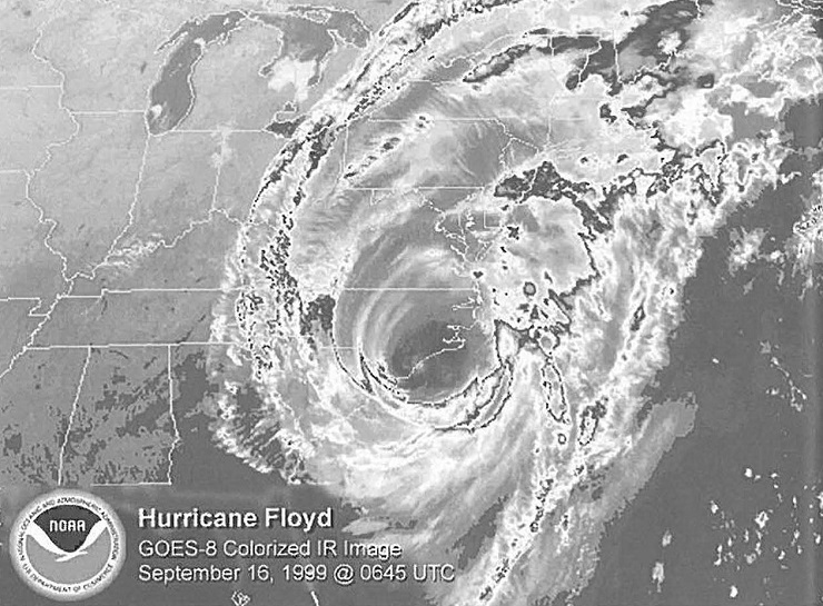
Heavy surf battered the coastline for days on end. Drenching rain was recorded well inland. As the warning coordination meteorologist, Laura Furgione was still working with county emergency management leaders to review damage surveys and conduct outreach when a new tropical system — to be named Floyd — was identified.
“The coastal region was saturated from Dennis, which had struck twice,” Furgione recalls. “Then two weeks later, here comes this big hurricane.”
Now an assistant administrator at the National Oceanic and Atmospheric Administration (NOAA), Furgione will discuss “then and now” when she is a featured speaker at the Hurricane Floyd Symposium, hosted by the East Carolina University Center for Natural Hazards Research on Sept. 17 and 18.
As Floyd approached, Furgione was alternating 12-hour shifts with Tom Kriehn, then the meteorologist-in-charge at the Newport office. But when her shift ended at 4 p.m., she found herself continuing to track the storm. “Sleep was impossible with the weather radio nearby,” she says with a chuckle.
The storm moved up the coast, dumping rain all the way to Maine. Yet the Newport office stayed on alert, monitoring the flood potential for eastern North Carolina. Clear roads allowed her to travel home, but some colleagues napped on cots in the office.
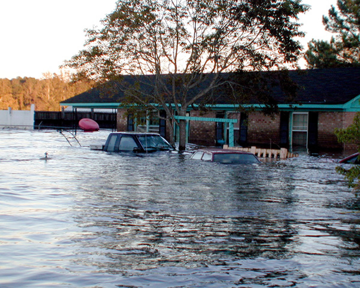
One team member — Central Willis – slept in his car so that he could provide river flood measurements on the Tar River when the electronic data system went down. “If we didn’t have the information, we would not have been able to provide advance notice to the community on the river’s record levels,” she explains.
Although the storm winds had passed, creeks and streams overflowed with runoff for days, sending more water into already full coastal rivers, which hit 500-year flood levels.
“Many counties were completely underwater: Duplin, Jones, Greene, Lenoir, western Craven and Pitt,” she says. “The Neuse River in Kinston had a 27.7-foot crest on Sept. 23. Flood stage is only 14 feet.”
Recovery was hampered as even more rain came. “Don’t forget Irene brought additional rainfall. We were putting out flood warnings through mid-October.”
LESSONS LEARNED
When Furgione mentions NOAA’s current national “Turn Around, Don’t Drown” campaign, she does so with memories of Floyd’s toll. “Fifty lives lost could have been avoided by the people not crossing flooded roadways.”
Although some basic flood safety messages are the same today as in 1999, there have been many improvements for agencies and communities. “When Floyd was occurring, we didn’t have some advanced technologies,” Furgione notes. “Now we have AHPS – the Advanced Hydrologic Prediction System.”
NOAA programs combine to provide a variety of “information-rich graphical products” that help emergency managers, state officials, local leaders, the media, residents and visitors make decisions.
Furgione now leads NOAA’s Office of Program Planning and Integration or PPI — key missions as the agency strives to increase collaboration within NOAA, as well as with other federal, state and local programs.
For example, when Floyd hit, the “StormReady Community” program was just starting. Now there are nearly 1,500 counties and/or communities that have earned the NOAA distinction, including nearly 60 in North Carolina. The designation recognizes communities that have identified resources and established plans to respond to the threat and arrival of a storm. In addition, NOAA has expanded its collaboration with the U.S. Geological Survey, in the Department of the Interior, to share information from river water gauges. “I can’t say enough about that partnership.” she adds.
Furgione admits that early in her career, she was focused on storms. “I didn’t even know the full breadth of NOAA’s responsibility.”
She left North Carolina in 2000 to lead the weather office in Juneau, Alaska, eventually moving up to be Alaska regional director from 2004 to 2008 before moving to the NOAA headquarters just outside Washington, D.C. Now, when a coastal storm is named, she also thinks about the mitigation efforts in communities along its anticipated path, and the storm’s potential impact on fisheries and ecosystems.
“Today, I can see how we can all work together — NWS, NMFS, NOS, Satellites, Research,” she says, citing several NOAA line offices by their acronyms. Such collaborations result in restored habitats, resilient communities and better research to help wide audiences, she adds.
That wider vision serves Furgione well, as her official NOAA biography describes her current duties: “In this role, she is responsible for corporate management to coordinate the many lines of service of this $4 billion agency dedicated to understanding and predicting changes in the Earth’s environment and conserving and managing coastal and marine resources. She is responsible for annual planning as well as long-term strategic planning, performance evaluation, program integration through matrix management, and policy integration including compliance with the National Environmental Policy Act. “That long explanation can be summed up in the description of regional collaboration efforts that Furgione coordinates. “The overarching, guiding principles are improving NOAA productivity and value to our customers,” she says.
The regional efforts are designed to increase collaboration, reduce duplication and provide concise messages. Each team includes representatives from the NOAA line offices, as well as other long-time NOAA programs, such as Sea Grant.
Similar efforts involve coordination across federal agencies. “With the new administration, we are reviewing the interagency ocean governance,” Furgione adds.
Climate is another topic that cuts across federal agencies — and it will be among the topics she will discuss at the ECU symposium that focuses on coastal storms. And what about September 2009?
“The outlook for the 2009 Atlantic hurricane season is near- to below-normal,” Furgione notes. “It only takes one storm to bring significant weather and conditions to your home. You and your family need to take precautions today. Do you have a plan?”
For more information on Hurricane Floyd, go to www.erh.noaa.gov/mhx/Floyd. — K.M.
ECU HOSTS FLOYD SYMPOSIUM
The Center for Natural Hazards Research at East Carolina University will host a two-day Hurricane Floyd Symposium on Sept. 17 and 18 to commemorate the 10th anniversary of the storm and its deadly floods.
The Thursday session will include local and state officials who will discuss the lessons learned from Floyd, as well as the current status of then-flooded regions. The afternoon session is free and open to the public. Former Gov. James B. Hunt Jr. is scheduled to speak.
The research conference on Friday will look at a variety of issues related to hazard mitigation, storm prediction and response, and recovery of coastal communities. Speakers will include Laura Furgione, now an assistant administrator for the National Oceanic and Atmosphenc Administration. Furgione was the National Weather Service’s warning coordination meteorologist in Newport/Morehead City when Floyd struck.
All sessions will be at the City Hotel and Bistro in Greenville. Partners include North Carolina Sea Grant, the National Oceanic and Atmosphenc Administration, the National Weather Service and the University of North Carolina at Chapel Hill Institute for Public Health.
A Sept. 17 dinner is $30. The Sept. 18 conference is $40. For schedules, etc., go online to www.ecu.edu/renci/floyd. Or call 252/328-5718. Registration deadline is Sept. 14 for the dinner. Conference walk-in registration is available.
NOTE: The Hurricane Floyd Symposium Summary Report is available for download.
This article was published in the Autumn 2009 issue of Coastwatch.
For contact information and reprint requests, visit ncseagrant.ncsu.edu/coastwatch/contact/.
- Categories: