Students from the Tiller School in Beaufort help estuarine habitats by removing marine debris from the Rachel Carson Reserve. Photo by N.C. Coastal Reserve
By MICHELLE BRODEUR
Michelle Brodeur is a communications specialist with the North Carolina Coastal Reserve and National Estuarine Research Reserve.
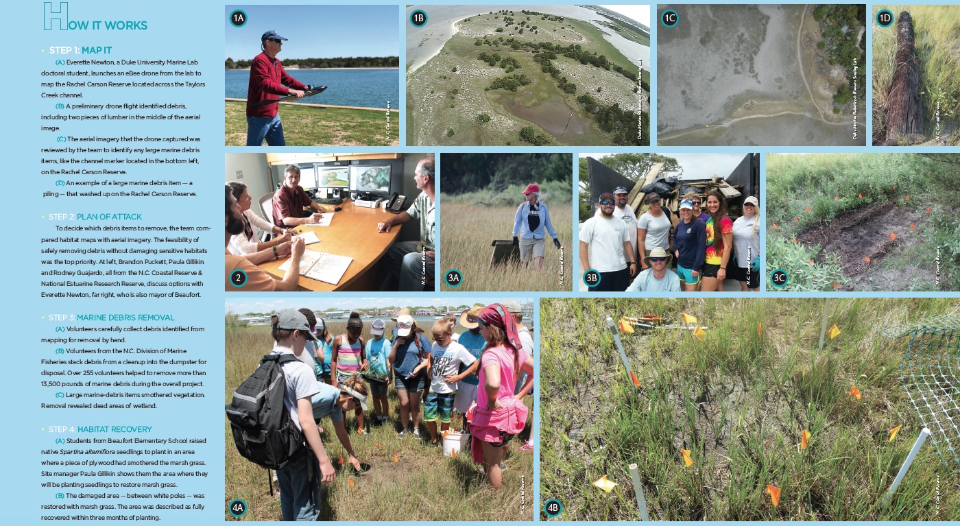
On the horizon, a silhouette rises into the air and moves toward the Rachel Carson Reserve, part of the North Carolina Coastal Reserve and National Estuarine Research Reserve. Paula Gillikin, the site’s manager, grabs her binoculars to get a better view.
Though reminiscent of a bird, the shape belongs to a drone, Gillikin’s newest tool in the fight against marine debris that is littering the North Carolina coast in general and the reserve in particular.
Located between the mouths of the Newport and North Rivers, and two miles from the Beaufort Inlet, the five islands that make up the Rachel Carson Reserve are particularly prone to accumulating marine debris. The refuse consistently washes ashore from boaters, businesses, residences and improperly secured vessels and fishing gear, posing a major site management challenge.
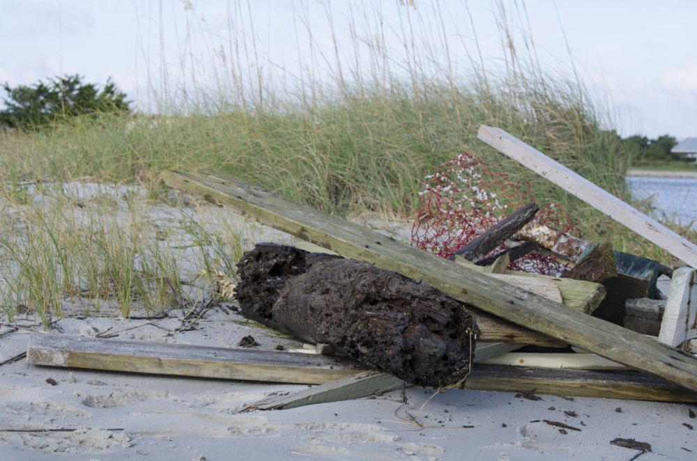
Volunteers had piled up wood and derelict fishing gear on the beach before Tow Boat U.S. could transport the items for disposal. Photo by N.C. Coastal Reserve
“Small consumer-generated debris items are manageable for volunteers to remove and document on a regular basis,” Gillikin says. “However, larger items are difficult and expensive to remove, and can cause damage to reserve habitats. Given our limited resources, we need an efficient way to assess debris and plan for its removal.”
Pieces of boats, docks and dock pilings that wash up can crush and smother vegetation, cause erosion and keep plants and animals out of their natural habitats. Such large items usually show up after storm and high-water events.
Larger items can be seen from many areas, but in remote areas debris can go undetected for months or even years. Surveying all five islands for debris by foot and boat would be a daunting task.
Gillikin needed a tool to quickly survey the entire reserve while causing minimal disturbance to sensitive habitats. She did not have to look far. Researchers at a brand-new facility next door at the Duke University Marine Lab had a solution.
With funding from the National Oceanic and Atmospheric Administration’s Marine Debris Program, the Reserve program and a team from Duke set out to use drones to map larger marine debris across the Rachel Carson site.
A BIRD’S-EYE VIEW
“Drones are revolutionary technology for studying coastal systems — including assessing marine debris,” says David Johnston, director of Duke’s Marine Robotics and Remote Sensing Lab, known as MaRRS. “When compared to traditional approaches to surveying coastlines, they are cheaper, safer and often produce better data. Having on-demand remote sensing capabilities changes how researchers and managers can study and conserve coastal ecosystems.”
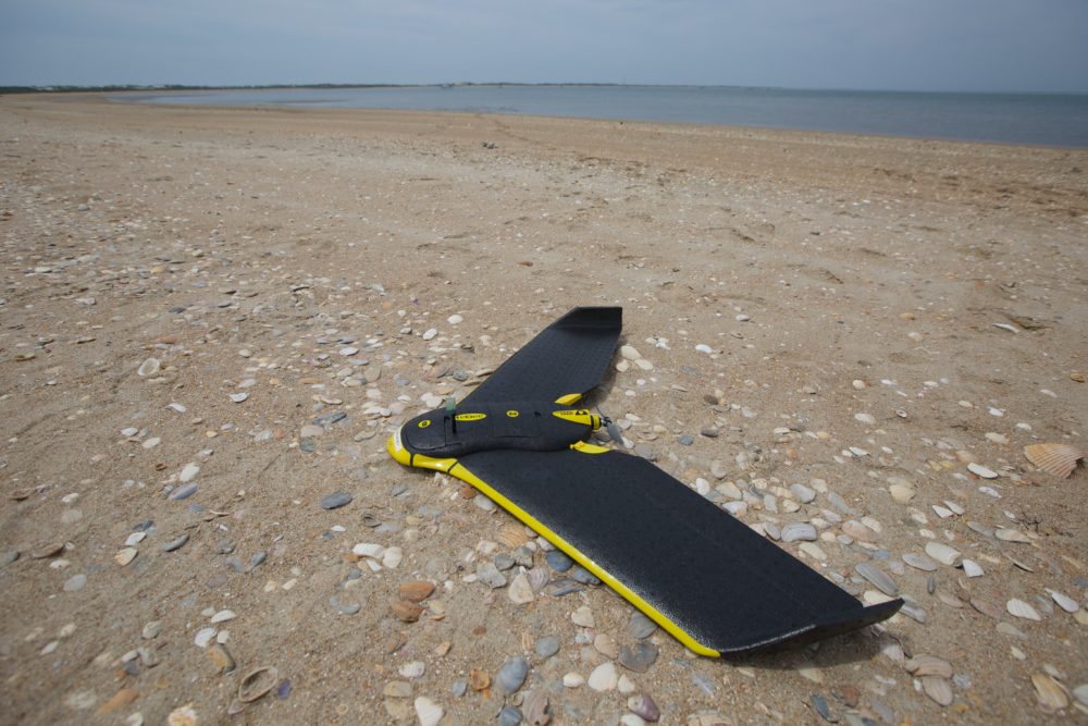
The Duke team uses a drone that captures high-resolution aerials images that can be transformed into maps. Photo by Duke Marine Robotics and Remote Sensing Lab
In the fall of 2016, Johnston’s team captured high-resolution imagery of the entire Rachel Carson Reserve using drones.
“We were able to clearly show that aerial drones can be a cost-effective way of scanning broad areas of coastal ecosystems for medium- to large-scale marine debris in a relatively small time,” explains Everette Newton, a Duke doctoral student and MaRRS program manager. “This is particularly profound when you consider that drones can survey areas that may be difficult for humans to access.”
The aerial imagery does an excellent job showing large debris items. Estimates based on aerial imagery identify the size of a debris item within 12 percent of its actual size when measured on the ground. Differences between the measurements are largely due to vegetation hiding the edges of debris from aerial views. Most often, imagery identifies the debris’ type and material.
“Once we identify debris on the survey maps, the next step is prioritizing which debris to remove, based on costs and the relative potential habitat benefits,” Gillikin says. “The project team uses an established habitat map of the site laid over the debris survey map to review options and discuss a plan of attack.”
A TEAM EFFORT
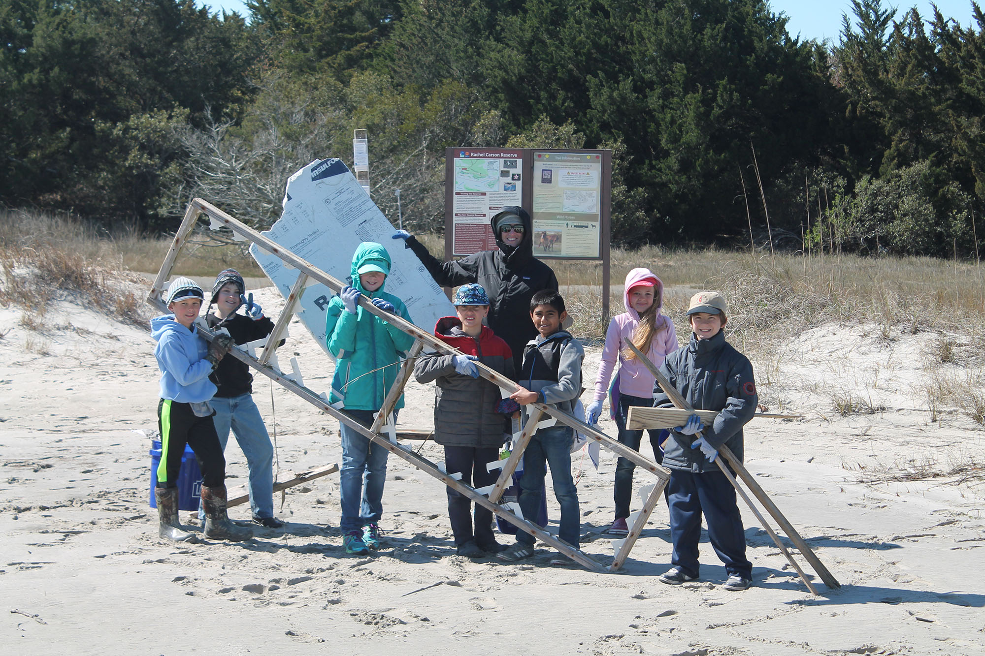
Once marine debris is identified, removing it is no small task. Waterlogged pilings and dock sections are incredibly heavy and require a plan — and help from partners — to remove. The Reserve team worked with Tow Boat U.S. – Atlantic Coast Marine Group, the N.C. Maritime Museum in Beaufort and the Town of Beaufort to collect and dispose of the debris in 2016. The team also recruited many hands from the community to help clean up the reserve.
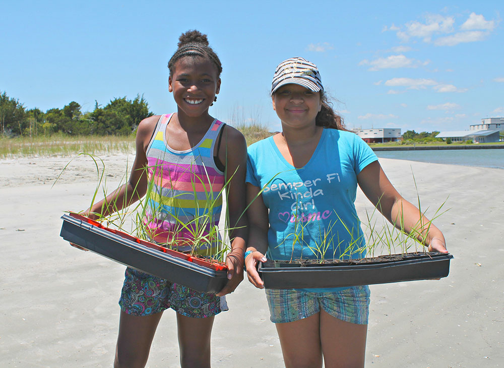
Beaufort Elementary School students proudly show off the salt marsh plants they helped to propagate from seed to restore an area of marsh damaged by marine debris. Photo by N.C. Coastal Reserve
Volunteers found the medium and large debris items identified from the aerial imagery, worked together to carefully remove it, collected basic data on the size and makeup of the debris, and handed it off for disposal on the mainland. Most of the large debris consisted of pilings, dock sections and lumber. Smaller debris items also were removed by volunteers — and to no surprise, the vast majority was plastic.
Because marine debris items often have lasting effects on the sensitive habitats where they land, the team monitored damaged areas for habitat recovery.
“We followed six areas where the habitat had been damaged by large debris items in the marsh and dunes,” Gillikin explains. “After one year, the diversity of plants increased by more than 90 percent and vegetation cover increased by more than 900 percent. We were happy to see that the habitat could recover in that timeframe.”
To boost habitat recovery in other areas — and to offer hands-on learning opportunities — the Reserve team called upon its Seeds to Shoreline Program, where schools raise native Spartina alterniflora, or smooth cordgrass plants, to use in restoration efforts.
In spring 2017, Beaufort Elementary School raised 50 seedlings to plant in an area where a piece of plywood had smothered the marsh grass. Within three months, the Spartina plants were growing well and had filled in the damaged area.
Newton, who is also the mayor of Beaufort, sees the need for marine debris surveys in ongoing coastal management at various levels. “These efforts are a major step forward in assessing the magnitude of marine debris for municipalities, so they can implement measures to reduce this risk to human health and coastal ecosystems,” he says.
SCALING UP
To enhance the public’s understanding of the marine debris problem and how technology can help to address it, the project team set out to engage the community through more cleanups, social media, presentations and field trips to the site. In addition, the Duke Community Science Marine Debris Initiative pitched in by incorporating aspects of the project into field and classrom activities.
Over the two years of the project, 255 volunteers helped to remove more than 13,500 pounds of marine debris.
This project, along with many others, has served as a catalyst for the larger effort of developing a coastwide marine debris reduction plan for the state. The N.C. Coastal Federation is leading the planning effort with help from the Reserve program, North Carolina Sea Grant and the N.C. Marine Debris Symposium.
Gillikin is excited about this initiative. “The process of crafting a formal marine debris reduction plan is bringing together nonprofits, government agencies, researchers, businesses and citizens in an energized and collaborative environment,” she says. “We are working together to assess and capitalize on existing research and resources, identify needs, and come up with do-able strategies to beautify and protect our state’s coastline.”
Gloria Putnam, Sea Grant’s representative on the task force, agrees. “Marine debris is a concern because it can negatively impact community health, environmental quality and industry such as coastal tourism and wildlife,” she says.
“This plan will help address these issues by improving collaboration and maximizing efforts among those who have been working to reduce marine debris — along with those who want to find a place to plug into planned activities.”
Sea Grant has been a key partner in working with the N.C. Coastal Reserve and National Estuarine Research Reserve on marine debris topics over the years, as well as on ecosystem research in the 10 sites that make up the state’s entire Reserve system.
“As a research reserve, the Rachel Carson Reserve is a perfect place to test this new method, and its habitats, wildlife and visitors have benefited from the debris removal,” Gillikin says.
“Equally important, the project has demonstrated that aerial drones can effectively be used to aid in the identification of marine debris. The project team is excited to share the results with a wide audience to help support debris removal efforts in other areas.”
Interested in helping track marine debris? Download the Marine Debris Tracker app created by the NOAA Marine Debris Program & Southeast Marine Debris Initiative, or the CleanSwell app created by the Ocean Conservancy, on your smartphone to track the marine debris you remove. For a printable version of the “How It Works” guide below, click here.