By CHUCK BANGLEY
Chuck Bangley is a doctoral candidate in coastal resources management at East Carolina University. He earned his bachelor’s degree in marine biology at the University of Rhode Island, and completed his master’s degree at ECU studying the feeding habits of spiny dogfish sharks. He blogs at Ya Like Dags, and Southern Fried Science.
Margaret Garner works hard for her research.
“One thing I learned from this project is that it can be tough to access a randomly selected GPS point in a salt marsh,” admits the East Carolina University doctoral student. “Sometimes you literally can’t get there from here.”
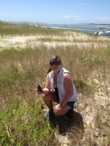
At randomly selected checkpoints, Margaret Garner used a handheld GPS to test the accuracy of habitat classifications derived through remote sensing. Photo by Kim Case.
She recalls an incident when she was trying to reach a point on her map. “I was up to my knees in oyster shells and mud. A man going by in a boat offered to help me and asked me, ‘Where are you from?’ I said, ‘Here.’ He said, ‘You should know better.’ ”
Garner’s struggles through the salt marshes of the Rachel Carson Reserve were just one part of her ongoing doctoral research. Her goal was to use the site’s unique combination of environments to predict what might happen to the coast of North Carolina if sea levels rise.
Field researchers often use relatively small, specific areas as natural laboratories to understand the workings of entire ecosystems and test how they respond to change. From the information provided by these field sites, scientists can predict responses in similar environments on a larger scale. These findings can be applicable to entire states or even entire coastlines.
Garner, who is in ECU’s coastal resources management program, was the 2013 North Carolina Sea Grant and the N.C. Coastal Reserve and National Estuarine Research Reserve fellow. She gathered data from a handful of small islands near Beaufort to help make predictions that may have far-reaching impacts for the North Carolina coast.
“The beauty of this joint fellowship is in its ability to leverage the partnership between Sea Grant and the Reserve,” says Brandon Puckett, the Reserve research coordinator. “Graduate students get the opportunity to creatively address complex coastal management issues by conducting cutting-edge research within the Reserve’s living laboratories.”
MAPPING THE MARSH
The Rachel Carson Reserve, part of the state’s Reserve system and a component of the National Estuarine Research Reserve System, proved to be an ideal site for Garner to examine the relationships between habitat, elevation and tidal range.
Offering a combination of terrestrial, intertidal and subtidal habitats, all compressed into an area of less than three square miles, the site contains a microcosm of the different habitat types present throughout coastal North Carolina. Its islands are easily accessible by crossing Taylor’s Creek.
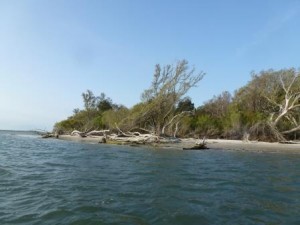
The islands in Rachel Carson Reserve are accessible by crossing Taylor’s Creek. Photo by Sharon Settlage.
“The Rachel Carson Reserve is representative of many islands that are found along our coast, particularly ones that are nested behind barrier islands,” notes Paula Gillikin, Carson Reserve site manager.
“It has everything from low marsh to cedars,” Garner adds.
First, Garner sought to update and improve existing maps of the site. Working in collaboration with Thomas Allen, who heads the N.C. Coastal Atlas project and is her advisor at ECU, she mapped habitat types on the islands in the Carson Reserve, based on dominant vegetation types.
Garner used a combination of remote sensing methods to map the island. She employed aerial photography from airplanes and satellites; synthetic aperture radar, known as SAR, from satellites; and light detection and ranging, or LiDAR, which uses laser reflection from a passing aircraft to map topography and vegetation. She calibrated the generated maps to accurate ground coordinates and filtered them to remove distortions and image flaws.
Finally, she classified habitat types within the site using a method called object-based image analysis, or OBIA. In comparison to traditional aerial photo classification, OBIA uses advanced statistical algorithms to identify habitat types based not only on color reflectance, but also the vegetation shape, pattern and topography. Garner was able to identify eight habitat types within the Rachel Carson Reserve, ranging from scrub-shrub forests to open water.
The next step was to verify these maps against the actual ground habitat, which put Garner knee-deep in the mud. She found that this emerging method enabled her to map the island habitats very accurately, with more than 90 percent of habitat areas correctly classified. This is a considerable improvement over traditional pixel-based methods of classifying remotely sensed habitat, which typically have about 75 to 80 percent accuracy.
Given these habitat classifications, and knowledge of their relationships with each other and the surrounding waters of Back Sound, Garner set about testing how the site’s ecosystems might respond to changes in the environment. She used the Sea Level Affecting Marshes Model, also known as SLAMM. This model simulates the processes of inundation, erosion, overwash, saturation and accretion to predict how coastal marsh habitats might change at a given sea level.
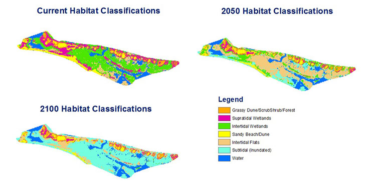
Margaret Garner’s research showed the current habitat extent and distribution on the site, and the changes predicted with a half-meter of sea-level rise, and one meter.
Garner plugged her landscape classification data into SLAMM to simulate potential changes under rising sea levels. She ran two potential scenarios through the model: a rise of half a meter projected to occur by 2050, and a full meter of sea-level rise projected to occur by 2100. These projections represent conservative estimates of global sea-level rise from the 2013 International Panel on Climate Change report. The results were dramatic.
Raising the sea level not only submerges low-lying areas, but it also can cause changes in nearby, nonflooded habitats. Soils may become too wet or unstable for certain vegetation communities, and salt water may intrude into areas where roots formerly were able to access fresh water.
When Garner applied SLAMM simulations to her habitat maps of the Rachel Carson Reserve, she found that it would look very different under each scenario. Currently, the islands making up the terrestrial part of the site are dominated by intertidal salt marshes, with bands of higher-elevation wetland and maritime forest along the northern edges, and some sandy dune areas along the southwestern shorelines.
With a half-meter of sea-level rise, the model indicated that the area of the Rachel Carson Reserve covered permanently by water could increase slightly. However, huge areas of salt marsh could be replaced by intertidal mud and sand flats as the marshes flood during high tide. Salt marsh habitats could be expected to expand inland, ahead of spreading intertidal flats, overtaking low-lying sand dunes and higher-elevation wetland areas. The bands of higher-elevation marsh and maritime forest could potentially break up into smaller pockets.
In the scenario with a full meter of sea-level rise, SLAMM showed that the majority of the Rachel Carson Reserve would be permanently under water. The projected one-meter rise in sea level would split the terrestrial portion of the Carson Reserve into tiny islands of high-elevation marsh and maritime forest vegetation. Some intertidal flats and sand dunes still could be found on the western side of the reserve. The low-lying salt marsh, unable to expand into higher elevations, virtually disappeared.
A MIGRATING COAST
For ECU’s Allen, Garner’s results underscore the importance of looking at the possible effects of rising sea level beyond flooding. “Marshes reflect landforms, and landforms reflect hydrology,” he explains, stressing the important connection between present-day landscapes and both current and ancient waterways.
The U.S. Geological Survey defines hydrology as the occurrence, distribution, movement and properties of the waters of the earth and their relationship with the environment.
Habitat types often are determined by elevation and access to water. The ecologically and economically valuable salt marsh habitats exist in a relatively narrow band of appropriately low elevation along the edge of the coast.
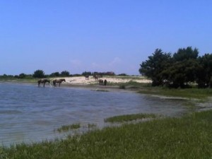
The site’s many habitats support a wild horse population. Photo by Margaret Garner.
According to Allen, hydrology contributes to creating salt marsh habitat through both the present-day presence of tidal creeks and sounds, and the low-lying, flat expanses of land, such as North Carolina’s coastal plain, left behind by ancient, higher sea levels.
In turn, changes in current sea levels also may alter the extent of salt marshes and other coastal habitat areas. According to Allen, the general trend among salt marsh habitat is to shift inland and into higher elevations as lower-lying areas are flooded. The “migrating” marsh overtakes and replaces other, higher-elevation habitat types, causing a cascading effect where coastal habitats continuously shift inland from the advancing water.
Further, some habitat types may reach a point where inland migration is blocked, such as by an area of steeply rising elevation. In this case — referred to as coastal squeeze — the marsh habitat may become trapped and eventually flooded. This is what happened to the salt marsh habitat in Garner’s simulations.
“Coastal hydrodynamics drive landform changes and in turn, vegetation changes,” Allen notes. This means that predicting the possible effects of sea-level rise requires more than simply determining which areas will and will not be under water in the future. As water moves inland, landforms and habitat areas will change ahead of it, and some isolated habitat areas may be squeezed out of existence.
PRECAUTIONARY APPROACH
The predictions generated from Garner’s simulation at the Rachel Carson Reserve offer new information that could help coastal communities prepare for the possible effects of sea-level rise.
Previously, state and federal agencies have mapped habitat areas by digitizing aerial photographs, a process that may be too slow to keep up with the rapid changes in dynamic coastal environments. Garner’s methods have made the process, in Allen’s words, “faster, better and cheaper,” allowing a more responsive approach to coastal management.
“Margaret’s methodology really pushes the envelope, and the results are promising for future mapping efforts,” he says.
This method now is being used to simulate marsh-habitat responses across the entire North Carolina coast, Allen notes. The results can be viewed online via the N.C. Coastal Atlas using the Marsh Migration Potential layer. The Coastal Atlas is an effort to make coastal data available to coastal managers, scientists, students and the public. In addition, Allen is applying the approach to a project that is mapping sea-level rise effects across the Southeastern United States.
“This direct application of Margaret’s research is very rewarding to see,” notes John Fear, Sea Grant deputy director. “One of the primary goals of this fellowship program is to support projects that can address high-priority coastal management issues, and her work is poised very nicely to do that.”
Garner wants to focus on the opportunity to better inform the public about the potential risks of sea-level rise, which she considers the most important outcome of her mapping efforts.
“My main interest has always been outreach,” she explains. “People tend to think ‘an inch of sea-level rise’ just means ‘an inch up the beach,’ not realizing their property might only have about an inch of elevation. I want to use these maps as part of an outreach effort to individuals, and help extend public participation in coastal policy making to the average citizen.”
In the meantime, those managing the Rachel Carson Reserve are glad to have more information about the site. “Margaret’s findings will be useful in informing future habitat and species vulnerability assessments and planning for monitoring, restoration and research projects,” says reserve manager Gillikin.
“Data gathered from the reserve, particularly when analyzed in conjunction with other applicable research, have the potential to make significant contributions to coastwide predictions,” she adds.
Allen is confident that what has been learned in this small collection of islands and marshes can be used to make informed coastal management decisions across North Carolina. Though the extent and effects of sea-level rise can be controversial topics, Allen and Garner prefer to let the science speak for itself.
They agree that changes will occur along the North Carolina coastline, with most scientific work focused on predicting the potential impacts of those changes. What managers and the public currently have available are a good knowledge of current, baseline conditions and a range of potential projections for the impact of sea-level rise.
“The next few decades will show the changes to the baseline, and will show which projection we’re actually on,” Allen predicts.
Puckett, the Reserve research coordinator agrees. “Margaret’s research is significant for a number of reasons including, but not limited to, the delivery of mapping products and vulnerability assessments within Reserve boundaries, the development of mapping methods applicable to coastal habitats beyond Reserve boundaries, and its timeliness as coastal decision makers consider how to increase the resilience of coastal habitats to increasing coastal hazards.”
This article was published in the Winter 2015 issue of Coastwatch.
For contact information and reprint requests, visit ncseagrant.ncsu.edu/coastwatch/contact/.